
A French documentary maker contends that a map error was one of the reasons that Napoleon’s army was defeated by the Duke of Wellington’s forces during the Battle of Waterloo.
What was the Battle of Waterloo?
The Battle of Waterloo, fought on June 18, 1815, marked the climactic end of the Napoleonic Wars and ultimately resulted in the permanent exile of Napoleon Bonaparte.
Occurring near the town of Waterloo in present-day Belgium, this decisive battle saw the French army, led by Napoleon, pitted against the combined forces of the Seventh Coalition, comprising primarily of British, Dutch, and Prussian troops under the command of the Duke of Wellington and Field Marshal Gebhard Leberecht von Blücher.
Napoleon’s attempt to regain power in France after his escape from Elba was thwarted by the coalition’s unwavering resistance and strategic maneuvers.
Despite early French successes, the timely arrival of Prussian reinforcements and the steadfast defense by British troops led to the collapse of the French lines, forcing Napoleon’s ultimate surrender.
Did a discrepancy between two maps affect the Battle of Waterloo?
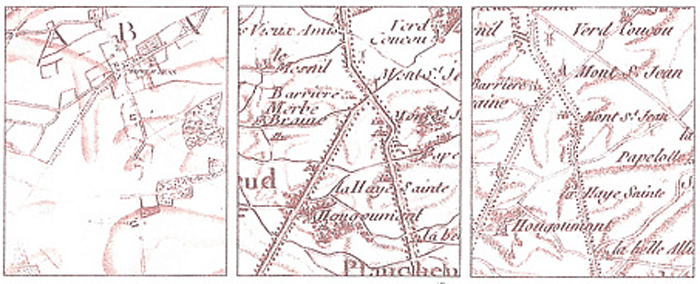
The documentary film by Franck Ferrand entitled, “Napoléon : le défi de trop ?” explores the finding by a Belgian illustrator and historian. Bernard Coppens noticed a discrepancy between the original hand drawn map and the printed versions showing the location of the farm of Mont-Saint-Jean.
The map error occurred when the printing process introduced a kilometer (roughly two-thirds of a mile) offset the farm of Mont-Saint-Jean where the Duke of Wellington’s forces were. As a result, Napoleon aimed his canons in the wrong direction, failing to impact the opposition.

“We compared the printed map used on the battlefield with the original hand-drawn one it was copied from,” Mr Ferrand said. “We realised it was a printing error. Not only was the farm in the wrong place, but the map showed a bend in the road that did not exist.”
“Napoleon was relying on a false map for his strategy in his last battle. This explains why he mistook the lie of the land and was disoriented on the battlefield. It is certainly one of the factors that led to his defeat, although not the only one.” Mr Ferrand explained: “The strategic farm of Mont-Saint-Jean is shown one kilometre from its real location. One kilometre was the range of his cannons so you can see what a difference it must have made.”
More: Map error hastened Napoleon’s Waterloo defeat