
Over the last six or so years, user-generated mapping has been exceedingly useful in times of crisis. From the 2010 earthquake disaster in Haiti to the 2011 earthquake and tsunami disaster in Japan, it has been vital in increasing the visibility of underserved areas, and saving lives in the process.
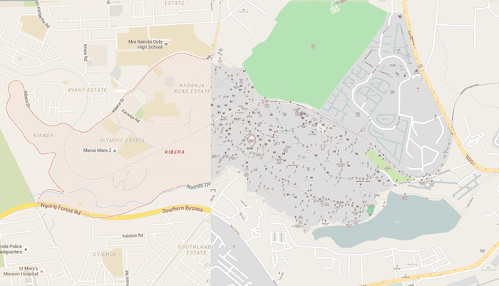
One of the latest ongoing, user-generated mapping projects involves the mapping of slums in Kenya. The project is being lead by Primož Kovačič, an engineer specializing in GIS and surveying. Over the last seven years, he has been teaching the citizens of Kenya’s two largest settlements, Kibera and Mathare, how to map their surroundings themselves. This is important because existing maps completely under-represent the actual geography of the two settlements, showing only some major roads and only barely-distinguishable features.
In an initiative backed by NGOs, and mapping organizations such as Map Kibera and Spatial Collective, citizens of Kibera and Mathare are trained by geographers and given GPS devices to map out what they consider to be the important geographical areas of their communities. This data is then brought back to the geographers, who upload the data points and perform a spatial analysis to better understand the communities.
The hope is that, by better understanding different aspects of the slums, they can highlight those aspects that are in dire need of improvement (ie. trash collection and healthcare). This process has already started to make a difference, as the mapping of one area in Kibera has allowed for its residents to apply for clean water. It’s another clear example of the importance and efficacy of user-generated mapping.

But still, despite the success of citizen-driven, DIY mapping, many geographical professionals remain skeptical. They question whether making a place more visible on a map is wise, as it also makes the place more vulnerable to people who want to exploit it. There are also the ever-present questions about data accuracy and precision; can non-GIS professionals truly be trusted to capture this important data?
Primož Kovačič certainly thinks so, and has no qualms about letting anyone know it: “People don’t take us seriously. They think if it’s not some kind of academic institution or the World Bank or some kind of Ph.D. people, it’s not worthy. But I can assure you that we can collect much better data than all of those institutions.” And he seems to have a pretty solid case for his assertion. Kenya’s slums are essentially non-existent on Google Maps, and it’s clear that none of the institutions mentioned has made any sort of honest attempt at mapping these areas anyway. If citizens don’t do it, no one will.
Regardless of whether or not some GIS professionals find user-generated mapping legitimate, it has made a difference. That can not be denied. And, with continued improvement and effectiveness, user-generated mapping will become more and more accepted by those in the geography community, and in turn, more and more legitimized.
More: ‘DIY Cartographers Are Putting Slums on the Literal Map’ by Erin Blakemore.