125 Million Building Footprints in the US Now Available as Open GIS Data

Caitlin Dempsey

Major content update:

Minor updates:

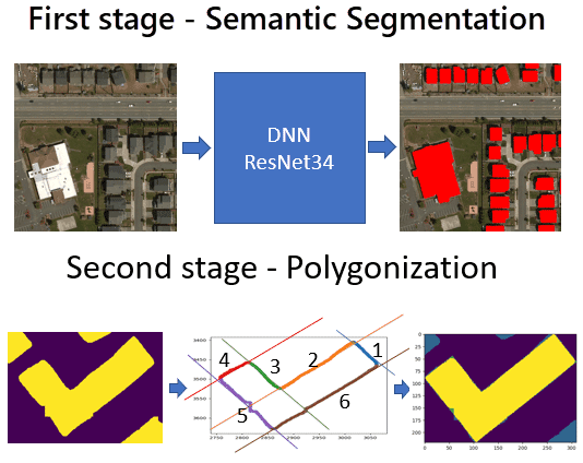
Microsoft has made 124,885,597 footprints from all 50 U.S. states available as open data.  The building footprints were extracted from Bing imagery using a combination of deep learning to identify building polygons and then a polygonization algorithm to clean up the edges of the buildings.

Microsoft's two stage process to extract and refine building footprints from aerial imagery.
Microsoft’s two stage process to extract and refine building footprints from aerial imagery.

This process was developed in order to rapidly increase the amount of building footprints available in OpenStreetMap.  The Bing Blog calculated that prior to this data delivery, OpenStreetMap had 30,567,953 U.S. building footprints.

An explanation of the process and free data download of the building footprint by U.S. state (in JSON format) is available from GitHub. The toolkit used by Microsoft is also available on  GitHub as well.

See Also

Photo of author
Caitlin Dempsey

Caitlin Dempsey is a geographer, writer, and founder and editor of Geography Realm. She holds bachelor's and master's degrees in Geography from UCLA and a Master of Library and Information Science (MLIS) from San José State University.

For more than two decades, she has written about geography, maps, geographic information systems (GIS), remote sensing, satellite imagery, and environmental science. Her work focuses on making geography accessible to a broad audience through articles, tutorials, and educational resources.

LinkedIn | Instagram