
Once the fourth-largest inland water body in the world, the Aral Sea shrank again in 2013. For the first time in modern history, the eastern lobe has completely dried out.
While the World Bank and Kazakhstan have collaborated to build the Kok-Aral dike which has helped to stabilize the northern section of the Aral Sea, the southern portions are projected to dry out by the end of the decade. By the 2000s, the southern portion had split into two lobes: western and eastern. The water levels in the eastern lobe have fluctuated wildly since then due to rain and snowfall levels watershed surrounding the Pamir Mountains. 2014 marks the first time in 600 years that the eastern lobe has completely dried out. According to Philip Micklin, a geographer emeritus from Western Michigan University and an Aral Sea expert, “it is likely the first time it has completely dried in 600 years, since Medieval desiccation associated with diversion of Amu Darya to the Caspian Sea.”
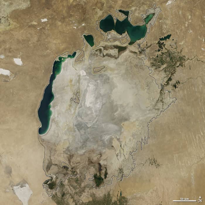
In the comparison slider below, the image on the left (before) shows the extent of the Aral Sea on August 25, 2000. The after picture was taken 14 years later by the same Moderate Resolution Imaging Spectroradiometer (MODIS) on NASA’s Terra satellite on August 19, 2014. Both images show a black outline of the original shoreline from 1960 before Soviet irrigation policies that diverted water from two sources, the Amu Darya and the Syr Darya drastically affected water levels. The desiccation of the Aral Sea has resulted in one of the world’s youngest deserts, the Aralkum Desert.
Use the slider to compare the changes in the Aral Sea to see how water levels have changed between 2000 and 2014.


References
NASA Earth Observatory. September 26, 2014. The Aral Sea Loses Its Eastern Lobe.