
Hydrology
Hydrology is a branch of geography that studies the properties of water on Earth, especially its movement in relation to land.

Water Can Take Years to Seep out of Mountains
Groundwater stored over many years is a significant contributor to streamflow in Western United States mountains according to a published study.
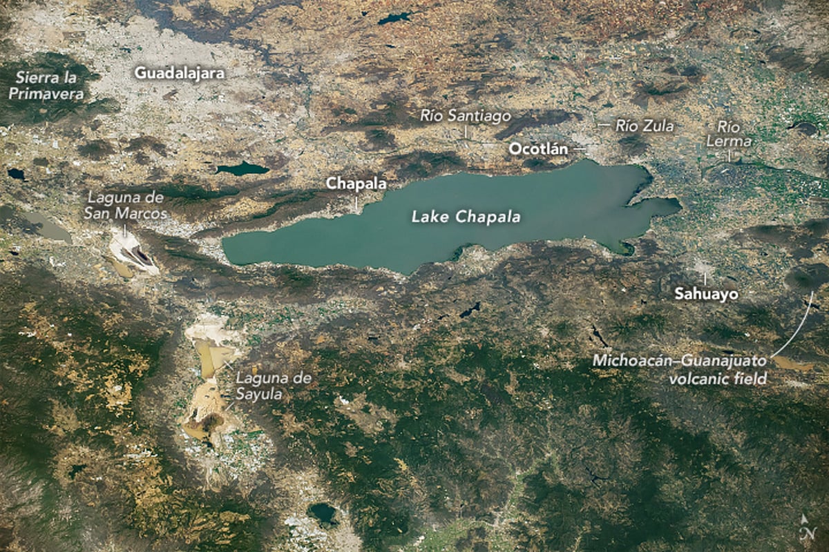
Lake Chapala: A Tectonic Lake Formed Where Three Grabens Meet
The geology of Lake Chapala reveals how faulting and volcanic activity shaped Mexico's largest freshwater lake.

Rivers that Flow Backwards
Read about how the Amazon once flowed east to west and how the strength of Hurricane Isaac once change the course of the Mississippi river.

Water on Earth
Earth holds trillions of tons of water, mostly in oceans. Only 2.5% is freshwater, primarily found in glaciers, groundwater, lakes, and rivers.

Which States Have the Highest Percentage of Water Area?
Water shapes U.S. states' geography and ecosystems. Which states have the highest and lowest percentages of area covered by perennial water?

When Rivers Become Ice Roads
During the cold winter months, parts of Canada's Mackenzie River become a ice road that trucks up to 22,000 pounds can navigate.

How Sea Level Rise Will Affect Salt Marshes
Researchers have calculated that about 90 percent of salt marshes are under threat from rising sea levels predicted to occur by the year 2100.

Surge Flows: A Rare River Phenomenon
Surge flows are a rare phenomenon where shallow waters, sand or sediment, and steep topography combine to create waves in rivers.

Third Order Islands
Islands with lakes or ponds that contain smaller islands within them are called recursive islands.

Blue Carbon Explained
Blue carbon is the carbon captured and stored by the world's oceanic and coastal ecosystems.

Snowmelt is Starting in California’s Sierra Nevada Mountains
Due to colder weather and more strong atmospheric rivers, the 2023 Sierra Nevada snowpack levels in California are significantly above average.

How California’s Ancient Tulare Lake Reappears
Tulare Lake used to be the largest freshwater lake west of the Mississippi.

Why Salt Flats Have a Honeycomb Pattern
Recently published research explains the scientific reason behind the honeycomb shapes found in salt flats.

What is a Closed Lake?
Closed lakes are bodies of water that do not drain into an ocean or river.

Over One Million Barriers on European Rivers
Over one million barriers disrupt Europe's rivers, impacting their flow, ecology, and economies.

Geography Definitions Related to Water
Listed here are geography terms related to water bodies such as lakes, rivers, and oceans.

The Global Evaporation of Lakes
Researchers used satellite imagery and modeling to calculate the evaporation volume across over 1.42 million natural and artificial lakes.

The Largest Delta in the Arctic
The Lena Delta is a significant wildlife refuge and the largest delta in the Arctic.

Waterfalls That Flow Into the Open Ocean
Waterfalls that flow directly into the ocean are known as tidefalls, a rare natural phenomenon where freshwater meets the sea.

Melting Glaciers and Larger Lakes
A global survey that used satellite data has determined that overall, glacial lakes have increased in volume almost 50% since 1990.

The Shortest River in the United States
The shortest river in the U.S. is Montana's Roe River, which stretches only 201 feet.

California’s Drought is Driving Reservoirs to Near Historic Lows in 2021
The second year of California's drought is driving down water levels in the state's reservoirs in 2021.
Geography of U.S. Lakes
Within its borders, the United States is home to a vast wealth of lakes.

California’s Largest Lake
Floodwater from a broken irrigation canal gate in 1905 created California's largest lake.

NASA Completes the First Global Survey of Fluctuations in Lakes and Reservoirs
ICESat-2 launched in September 2018) with its satellite laser altimeter, allowing NASA to perform the first global survey of freshwater fluctuations.
