
Glaciology

World’s Biggest Iceberg
The largest iceberg in the world is A-23A, with an area of about 1,240 square miles.

Glacial Flour Makes Some Lakes Turquoise
Glacial flour, the fine dust created as glaciers move over land, turns lakes a turquoise color by reflecting blue and green light.

Understanding Glacier Grounding Lines
Grounding lines are the boundaries where glaciers and ice sheets transition from resting on solid ground to floating on seawater.

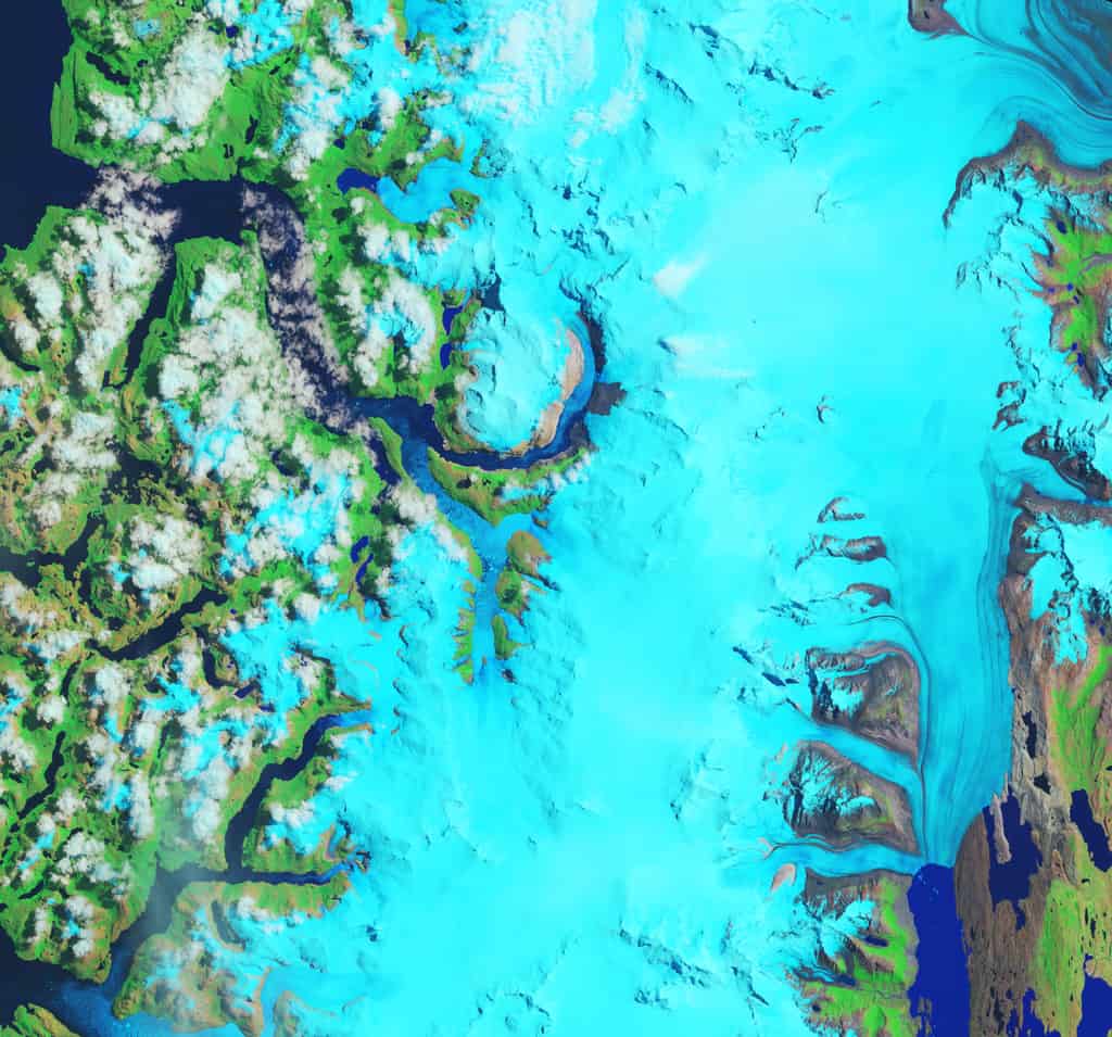
The Rise of Proglacial Lakes
Glacial retreat in Alaska's Yakutat Foreland has fueled rapid growth of proglacial lakes, doubling their size in 40 years as seen in Landsat imagery.

Venezuela Becomes the First Country to Lose its Glaciers
Venezuela became the first country to lose all of its glaciers as the last remaining ice on Pico Humboldt shrank to less than two hectares.

Understanding Fast Ice in Polar Ecosystems and Climate Dynamics
Fast ice, found in both polar regions, is sea ice that attaches to coasts, icebergs, ice shelves, or the ocean floor.

Nunataks: Glacial Islands
Nunataks are isolated mountain peaks visible above ice sheets in polar and high-altitude regions.

What is an Ice Arch?
An ice arch forms when sea ice buckles under pressure, creating a natural arch-shaped structure in polar regions, often blocking the movement of ice.

Mapping Glacier Loss in Western Canada
Researchers are using remotely sensed data and satellite imagery to map glacier loss in Western Canada.

Glaciers in the Antarctic Peninsula are Moving Faster During the Summers
Antarctic Peninsula glaciers are speeding up: Analysis of 10,000+ satellite images from 2014-2021 shows increased seasonal velocity in 105 glaciers.

Oldest National Park in Europe
Established in 1909, Sarek in Sweden is Europe's oldest national park.

Melting Glaciers and Larger Lakes
A global survey that used satellite data has determined that overall, glacial lakes have increased in volume almost 50% since 1990.

Why Is Antarctica’s Snow Turning Green?
The coasts of the northern Antarctic Peninsula are seasonally turning green, orange, and red - all thanks to microscopic algae.

Coastal Ice Loss is Outpacing Mainland Ice Gains on Both Antarctica and Greenland
A recent study has confirmed that the coastal ice loss is much greater than the mainland ice gain on both Antarctica and Greenland.

Lowest Latitude Sea Ice South of the Arctic
One of the lowest latitudes in the Northern Hemisphere where sea ice forms in the Northern Hemisphere is the Sea of Okhotsk.

Glaciers
Learn about glaciers including the types of glaciers and how glaciers move.

The Greenland Ice Sheet Has Lost 3.8 Trillion Tons of Ice
A new report analyzed 26 satellite datasets to track ice loss for the Greenland Ice Sheet.

How Ice Balls Form
When conditions are just right, a strange phenomenon called ice balls or ice eggs can form along beaches during the winter months.
Fastest Thinning Glacier
Hielo Patagónico Sur 12 (HPS-12) in Patagonia is believed to be the fastest thinning glacier in the world.

An Iceberg the Size of Greater London Has Broken Off Amery Ice Shelf in Antarctica
An iceberg the size of Greater London recently broke off the from Amery Ice Shelf in Antarctica.

In The Last Three Years Antarctica Lost Ice the Size of Greenland
A recent report published by the Proceedings of the National Academy of Sciences analyzed satellite data that showed Antarctica’s rapid sea ice decline.

Greenland’s Ice Arch Crumbles Earlier Than Normal
Across the Nares Strait, between Greenland and Ellesmere Island, lies a horizontal ice arch.

Large Glacier Flour Storm Captured by Satellites
When winds in Greenland are strong enough, they can carry large plumes of glacier flour that have collected on the floor of dried out floodplains.

Karakoram Anomaly
Landsat satellite data helped researchers analyze advancing glaciers in the Karakoram mountains, which is uncommon compared to most glaciers worldwide.

Ice Loss in Antarctica
In the last six years, a 750 kilometer (466 mile) strip of Antarctica has been shedding ice into the ocean at a rate of about 60 cubic km each year according to data collected from Cryosat-2.

Moraines
Moraines are the piles of dirt and rock that are displaced by a glacier as it moves across the landscape.