
When it comes to polar ice formations, you have undoubtedly heard of glaciers, icebergs, and ice sheets. But how about arches? Across the Nares Strait, between Greenland and Ellesmere Island, lies a horizontal ice arch.
What is an ice arch?
A southward flowing current carries a significant amount of ice through the strait in summer and fall. In other seasons, the ice arch which forms in late autumn or early winter keeps the sea ice from escaping the Arctic Ocean. Otherwise, the ice would drift away to the south, towards the Baffin Bay.
The arch forms each year in late autumn or early winter. It used to last until June or July when it would melt and crumble for the “summer break” described above. But not this year. In 2019 the arch crumbled as early as March, for the first time. The previous earliest melt happened in May of 2017.
What happens when an ice arch crumbles?
Nathan Kurtz, a sea ice scientist at NASA, explains that the timing of the arch’s breakup affects the amount of old, thick ice that flows out of the central Arctic region.
The early breakup contributes to the overall loss of Arctic sea ice thickness.
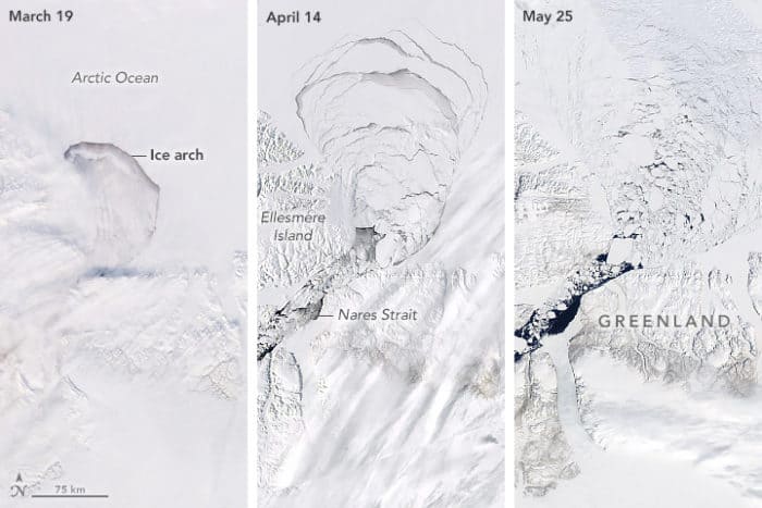
Time series satellite images of an ice arch crumbling
The arch’s disintegration was visible and captured from space by NASA – via Moderate Resolution Imaging Spectroradiometer (MODIS) on Terra and Aqua satellites, and also the Visible Infrared Imaging Radiometer Suite (VIIRS) on the Suomi NPP satellite.
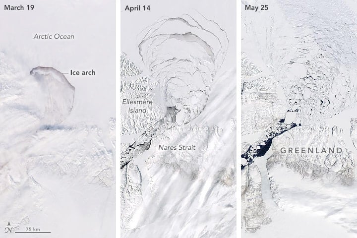
The image on the left (see image above this paragraph) shows the mostly intact arch on March 19, 2019. However, it contains a sign of things to come – the linear cloud streamers that usually form under the influence of strong winds are visible south of the arch.
Strong winds usually trigger ice melts. And indeed, by April 14 the middle part of the arch was crumbling. By May 25, the pieces of ice were flowing through the Nares Strait, unconstrained (right).
Other early ice arch break ups
Similar early breakups have happened before 2019 and 2017 – in 2010 and 2008.
In 2007, the arch failed to form. Scientists are now trying to pinpoint the exact reasons for this, now definitely re-occurring, phenomenon.
The University of Toronto paper on the early collapse of 2017 states that the unusual northern winds, the thin sea ice in the Lincoln Sea, and an area of open water in front of the arch are to blame for the event. The authors also point out that “if the ice in the region continues to thin, early collapses may occur more frequently with implications for the regional as well as the downstream climate and ecosystems.” They seem to be right.
Currently, the University of Toronto scientists are analyzing this year’s data to reconstruct what exactly caused the early collapse. Nathan Kurtz speculates that oddly warm temperatures and thin ice probably contributed to it. “It has been an unusually warm winter for the Arctic, in particular the area in the Lincoln Sea where the ice arch forms,” he said.

Kurtz also explained that the early melt itself would not be able to cause a great overall impact, but it is a part of a larger trend. “Luckily the Nares Strait isn’t that large compared to the much larger Fram Strait. The overall impact likely won’t be that large, but it’s still another contributor to the loss of Arctic sea ice, which has been ongoing for quite some time.”
According to NASA’s data, the Arctic sea ice is declining at a rate of 12.8 percent per decade. It is a situation when any contribution to the overall loss is a threat to the polar circle as we know it.
Resources:
Ice Arch Crumbles Early (2019) NASA Earth Observatory https://earthobservatory.nasa.gov/images/145232/ice-arch-crumbles-early
Breakdown of an Ice Arch (2017) NASA Earth Observatory https://earthobservatory.nasa.gov/images/90245/breakdown-of-an-ice-arch
Moore, G. W. K. McNeil, K. 2018. The Early Collapse of the 2017 Lincoln Sea Ice Arch in Response to Anomalous Sea Ice and Wind Forcing.Geophysical Research Letters, 45 (16), 8343–8351.