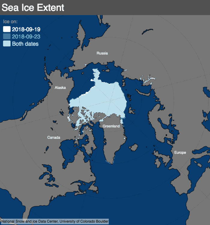
NASA and the National Snow and Ice Data Center, or NSIDC, have reported that arctic sea ice had most likely reached its lowest extent in 2018 on Sept. 19th, and again on the 23rd. When showcasing satellite data, it showed that 2018 has tied with 2008 and 2010 for the “sixth lowest summertime minimum extent” in their satellite record.
This news further showcases that increasing temperatures have led to strong, overall decreases in the extents of Arctic sea ice, exceedingly so in the minimum summertime extent. This decrease is expected to further affect the earth’s weather patterns, and the movement of its oceans.

This previous summer has shown some areas of the earth experiencing warmer than average temperatures with others remaining colder than what’s normally expected. Despite this mixture of changes, the minimum sea ice extent is stated as being, “629,000 square miles below the 1981-2010 average of yearly minimum extents.”
| RANK | YEAR | MINIMUM ICE EXTENT | DATE | |
|---|---|---|---|---|
| IN MILLIONS OF SQUARE KILOMETERS | IN MILLIONS OF SQUARE MILES | |||
| 1 | 2012 | 3.39 | 1.31 | Sept. 17 |
| 2 | 2007 2016 |
4.16 4.17 |
1.61 1.61 |
Sept. 18 Sept. 10 |
| 4 | 2011 | 4.34 | 1.68 | Sept. 11 |
| 5 | 2015 | 4.43 | 1.71 | Sept. 9 |
| 6 | 2008 2018 2010 |
4.59 4.59 4.62 |
1.77 1.77 1.78 |
Sept. 19 Sept. 19 & 23 Sept. 21 |
| 9 | 2017 | 4.67 | 1.80 | Sept. 13 |
| 10 | 2014 2013 |
5.03 5.05 |
1.94 1.95 |
Sept. 17 Sept. 13 |
| 12 | 2009 | 5.12 | 1.98 | Sept. 13 |
Source: National Snow and Ice Data Center
2018’s melt season has also seen the reopening of a hole in the icepack north of Greenland, where the thickest of the Arctic’s sea ice is found. This past February, a similar opening was seen, leading to speculation that the region could become vulnerable if this original ice cover is replaced with thinner ice, when the exposed water freezes over.
The past four decades has had less complete measurements of sea ice thickness, when compared to the overall volume and mass changes of the sea ice cover. But with the recent launch of NASA’s Ice, Cloud, and land Elevation Satellite-2 – or ICESat-2 – scientists will be able to use satellite data to create more detailed maps of sea ice thickness in both of Arctic and Antarctic regions.
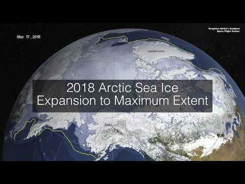
Watch: 2018 Arctic sea ice ties for sixth lowest minimum extent on NASA record

References
- Video sourced from NASA Climate Change
- Lowest sea ice minimum extents on record(chart)
- View NASA.gov’s article here
See Also