
Olivia Harne

Industrial Fishing Has a Global Impact on Bird Populations
A study published in Current Biology - from the Sea Around Us project at the University of British Columbia and French National Center for Scientific Research in Montpellier - provides evidence that industrial fishing practices are starving seabirds around the world.

Climate Change Impacting Sea Turtles
What Mass Audubon describes as a, “weather system of gale force winds” is now causing frozen turtles to wash up on New England beaches.

2018 National Climate Assessment Warns of a Future with More Extreme Weather
The 2018 National Climate Assessment presents stark news for climate change and our environment.
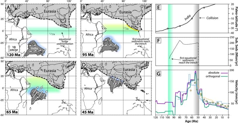
The Link Between Organisms and the Movement of Continents
New research indicates that sediment subducting beneath tectonic plates may regulate their movements.

Japanese Islet Disappears
A Japanese islet named Esanbe Hanakita Kojim made news after seemingly vanishing.

Mapping the Progression of Invasive Species with Crowdsourced Data
Researchers have mapped out approximate 48,510 harlequin ladybird (Harmonia axyridis) sightings – all obtained through participation of the public – over the course of a decade.

Mapping Mediterranean UNESCO World Heritage Sea-level Rise Flood Risk
A Kiel University study has shown that some World Heritage Sites are at risk for damage in the face of changing sea level from climate change.

Mapping Native Lands
Canadian developer Victor Temprano- founder of Mapster - has created “Native Land,” a map that helps individuals find the original inhabitants of the land they live on.

What a Study of a 130-year-old Brain Coral Means for Open Ocean Health
A team of researchers at Princeton University were able to measure the nitrogen in the coral skeleton to analyze nitrogen pollution, and found it on a far lower level than what had been previously estimated.

Guardacostas Pro: Tracking Illegal Vessels
Argentina’s coast guard, or the Prefectura Naval Argentina will utilize Esri’s platform to create a new, real-time tracking system, aptly titled “Guardacoastas Pro.”

Lowest Arctic Sea Ice Minimum Extent for 2018
2018 has tied with 2008 and 2010 for the “sixth lowest summertime minimum extent” for the Arctic based on satellite records.

Mimicking the Geography of Distance with Letter Writing
Slowly is an interesting social network that reinstates the distance of geography when communicating with others when writing letters.

Mapping the Best Route for Pedestrian Safety
A team of researchers has published a study that calculates the best pedestrian route based on safety over finding the shortest route.

The Role of GIS Librarians
The learning curve with most GIS software can be lessened with the help of librarians that are able to explain software, recommend useful media, and preserve geospatial data.

Online Accessibility Maps Should be Interactive
For a consistent experience across mobile devices, accessibility maps should be interactive instead of static images or PDFs.

GIS, Data Preservation, and Gentrification
Olivia Harne discusses how smart planning that incorporates GIS needs to take into account the historic identity of gentrifying neighborhoods.

Collaborative Documentation of Online GIS Applications
Olivia Harne discusses the need for adequate documentation by project members when developing online GIS applications.

Streamline GIS Project Workflow with Online Recordkeeping
For efficient collaboration on a GIS project, document and catalog all work in an easily accessible location to overcome common challenges with diverse skill sets.
Sub-surface Mapping and Subterranean Data Representation
ArcGIS Online advances sub-surface mapping with 3D options, enhancing design, accessibility, and customization for urban planning and transportation.

How Agencies Can Harness Geosharing to Improve Infrastructure
How can communities become more engaged with reporting issues with infrastructure? Olivia Harne discusses how an investment in geographical data sharing could be a potential solution.
Using Geolocation to Connect Geography with Genealogy
The ability to create a potential geographic scrapbook could add a new dimension to the popularity of genealogical research.