
GIS Industry
Articles about trends and advancements in the geospatial industry.
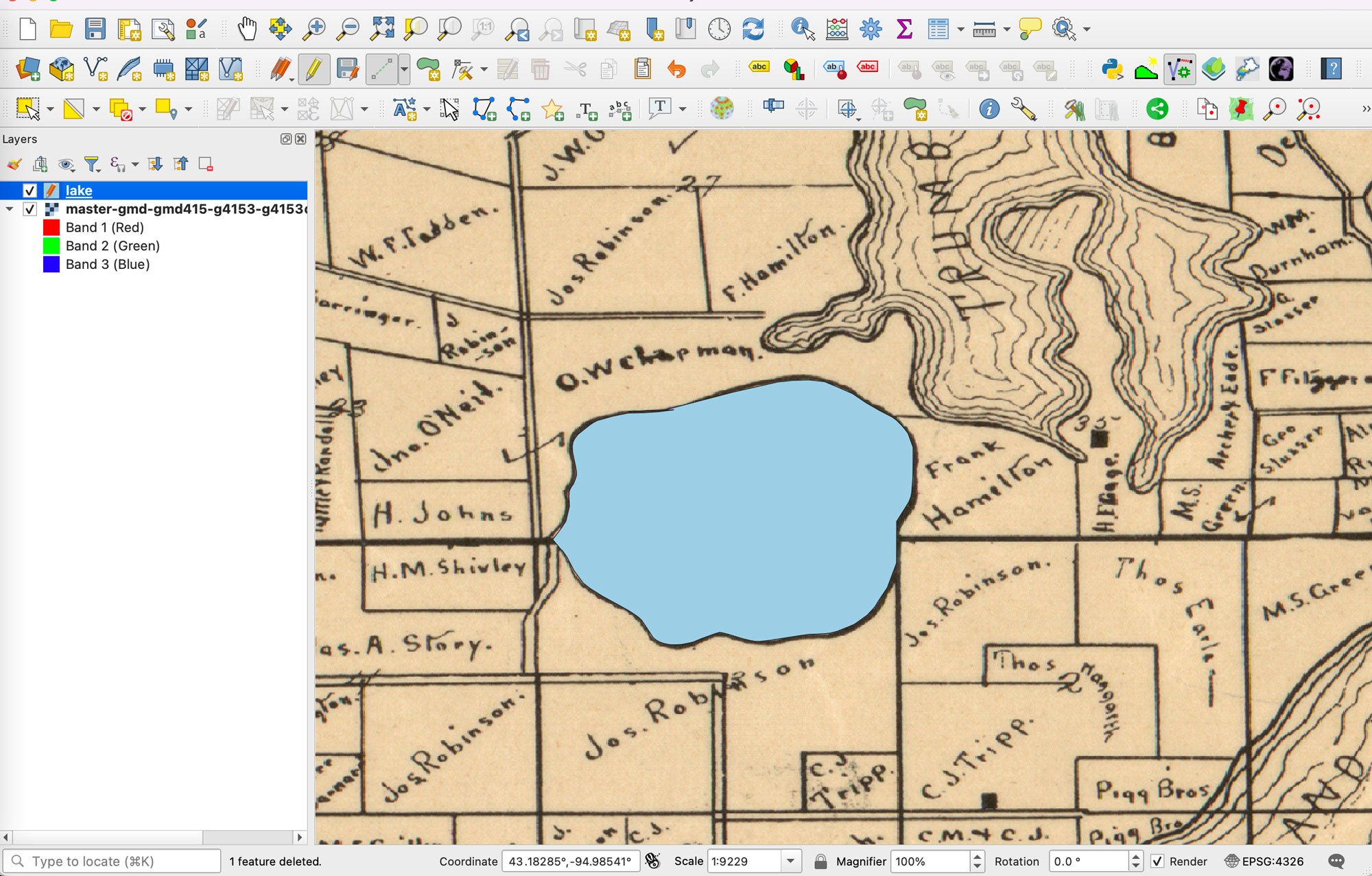
Using AI to Digitize Data From Scanned Maps
This AI-powered plugin is designed to automate the digitization of data from scanned maps and PDFs in QGIS for GIS users.

GIS and Map Contests
Current map and GIS related competitions listed in order of the competition deadline.
Where Should You Ask Your GIS Questions?
Here are some excellent resources for you to get peer assistance for your GIS related questions.

Remote Sensing for Carbon Offsetting
Remote sensing and geospatial technologies are being harnessed for carbon offsetting efforts.

Using Open Source Geospatial Data in Journalism
Geospatial data such as satellite imagery can be used by journalists to verify news stories.

A Roundup of Geospatial Podcasts
Here's a list of GIS / geospatial podcasts you can listen to.

Can GIS Help Ease Supply Chain Problems and Inflation?
GIS and spatial technologies could help to lessen the impact of supply chains, which are causing some of the high inflation prices.

Measuring Nitrogen Dioxide Levels in Urban Zones using Geospatial Methods
Earth observation and geospatial techniques have improved the ability to measure nitrogen dioxide at ground level.

The Role of UX and UI in GIS
Jeff Siarto of Element 84 talks with the MapScaping Podcast about the evolving role of design in the geospatial industry.
Providing a Voice Interface for Geospatial Data
Qwhery CEO Matt Pietryszyn discusses his smart speaker application Q11, that uses voice assistant technology to answer geospatial data queries.

Mapping Ocean Currents
Mapping ocean currents and understanding how they vary is critical for geographers and scientists, especially as our globe changes.

You Are Here: How Google Improves Mobile Location Accuracy
Ed Parsons explains how Google continues to innovate in the location technology sector.

Remote Monitoring of Construction Using Geospatial Technologies
ConsTrack uses satellite imagery, remote sensing, and machine learning to monitor construction activities.

GIS, Spatial Data, and Agroforestry
Geopatial analysis and GIS are crucial tools for assessing the quality and types of landscapes suited for growing various types of vegetation.

Ethics in GIS
With more ways to gather geospatial data and share that information, ethics has become even more important to consider.

Cybersecurity and GIS
GIS can play an important role in ensuring protection of vital infrastructure and data networks.

5 Reasons why the GIS industry continues to grow
If you work in GIS, you have seen tremendous growth in software sales, services, and solutions over the past 20 years.

Carbon Mapper: A Collaboration to Map Greenhouse Gas Emissions
A new, non-profit organization, Carbon Mapper, is attempting to create better ways to pinpoint methane and CO2 emissions.

Autonomous UAVs and Geospatial Data
Autonomous UAVs are already performing a variety of tasks using geospatial data obtained in-flight.

Why the ‘One Map Fits All’ Approach Doesn’t Fit All
A custom map stack can help leverage maps in new exciting ways.

Building a 4D World
VoxelMaps describes how they are creating a global 4D map that can capture outdoor and indoor spaces at different spatial and temporal scales.

Mapping Ground Subsidence
Synthetic Aperture Radar (SAR) can map subtle differences in the rates of subsidence.

NextBillion AI Solves HyperLocal Geospatial Infrastructures To Advance Mapping Ecosystems
NextBillion AI builds AI-based geospatial infrastructures to strengthen logistics, transportation, and supply chain services throughout the ecosystem.

Augmented Reality and Computer Vision in Navigation
The use and field of AR and computer vision are rapidly changing in how these technologies are being used in navigation.

Spatially Intelligent Warehouses
The adoption of warehouse spatial intelligence (WSI) can help to reduce waste, producing mainly what we need rather than over producing while ensuring needed products can reach consumers more quickly.

Benefits of Satellite-Based Augmentation Systems
Satellite-Based augmentation system (SBAS) services provide capabilities to improve location data for global positioning system (GPS) devices.