
GIS Industry
Articles about trends and advancements in the geospatial industry.

How the Biotech Industry is Using Spatial Analysis
The biotech industry is using spatial analysis as part of its efforts to develop rapid medical advancements that can help fight some of our most challenging diseases.

Businesses Using Open Source GIS
Businesses are using open source GIS software, finding that there are a lot of benefits along the way.
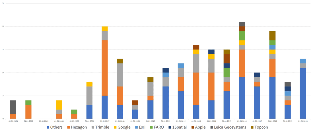
Mergers and Acquisitions in the Geospatial Market (2001-2020)
Andrey Pirogov, founder of GISGeo Project, takes a look at mergers and acquisitions in the geospatial technology market from 2001 to September 2020.

The Potential Role of GIS in COVID-19 Vaccine Distribution
GIS can play a role in developing protocols for the distribution of COVID-19 vaccines.

Self-employment in GIS
Self-employment in the GIS industry may seem daunting, but a recent MapScaping podcast with Kurt Menke, founder of Birds Eye View GIS, discusses how to build your own business.
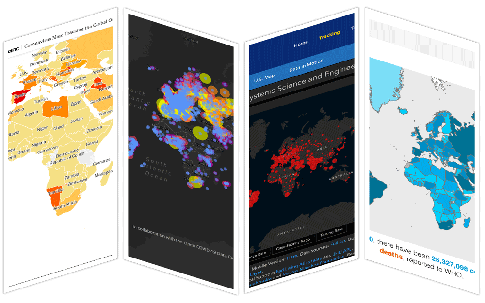
Online COVID-19 Maps and the ‘Infodemic’
Researchers have been evaluating the effectiveness and accuracy of online CoVID-19 maps.

The Spatial Internet of Things
The development of small sensors is providing a variety of real-time geospatial data.

GIS: Thinking Beyond the Map
Now more than ever, GIS data is being used among a diverse set of industries and users.

Improving Urban Decision Making with Open Earth Observations
Steven Ramage, Head of External Relations, Group on Earth Observations (GEO), outlines innovative partnerships and activities GEO has been working on globally using open Earth data, GIS, and cloud technologies.

GIS and the Future of Public Health
Mark Altaweel takes a look at how GIS is used in public health and where GIS and public health will be in the future.

What to Expect With the Esri Virtual Conference
This year the Esri UC 2020 will be held from Monday, July 13 to Thursday, July 16, 2020 as a virtual conference.

The Importance of GIS
David Falk writes about how GIS plays an important role in his career as an Army Officer, in his field as an engineer, and in his civilian life as potential homeowner and resident.

Using Geospatial Technologies to Map and Track Food Supply Chains
Geospatial and Big Data firms such as Orbital Insight are using and combining satellite data, cellphone geolocation data, and UAV data to track food supply chains.

Geolocation Data, Geofencing Warrants, and Crime
With most adults carrying mobile devices that have GPS tracking capabilities, mapping our movements has never been easier.
How to Volunteer Your GIS and Cartography Skills
Those with GIS and cartography skills that want to volunteer to help out can do so remotely with these calls for actions as mapping non-profits respond to the coronavirus pandemic.
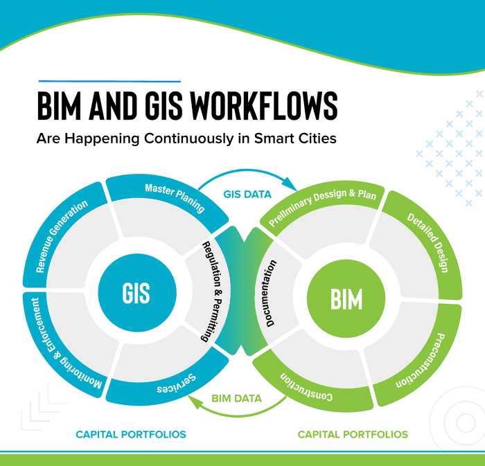
GIS and BIM Integration in Infrastructure Design and Construction
The latest advancements in geospatial services are making changes in the AEC industry. BIM for infrastructure design helps improve the workflow and saves valuable data through every stage of the process. Read about how GIS and BIM integration will transform these industries.
Geotargeting by Advertisers and Government Agencies
Geotargeting by advertisers, which is the practice of sending advertisement based on location, has gained increased importance for companies marketing their product in recent years.

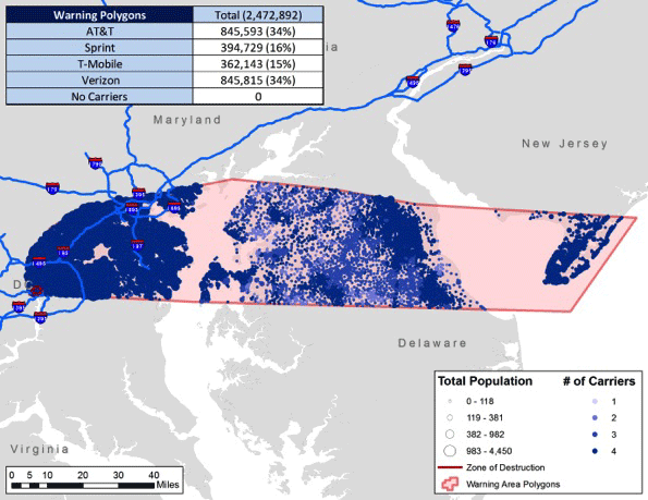
How GIS is Used in All Phases of Emergency Management
In this guest article, Brian Sekita discusses how GIS is vital to all phases of the emergency management process.

Using GIS to Map and Track Vandalism
GIS is being used to better understand current and potentially future patterns of vandalism.

Using GIS to Assess the Impact of Electric Cars
GIS and spatial analysis may help find some practical solutions for electric vehicle charging.
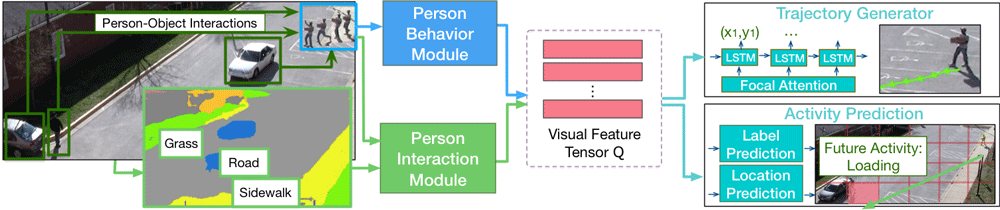
Predicting Future Movements of Pedestrians and Autonomous Vehicles
As driverless cars and motion detection technologies are increasingly integrated into our everyday lives, applications are now being developed to help with predicting movements undertaken by both pedestrians and vehicles.

Map of Geospatial Companies Around the World
Christoph Rieke has assembled a growing list of commercial geospatial companies with offices located all around the world.

Learn How GIS and Earth Observation Can be Used to Support the United Nations Sustainable Development Goals
Earth Observation and GIS technologies have a huge impact on both monitoring the implementation of the United Nation's sustainable development goals.

Understanding LiDAR Technologies
This article presents insights from the new IDTechEx report titled “Lidar 2020-2030” IDTechEx report.

The Critical Role of GIS in NG9-1-1
Drew Fioranelli, GISP, Public Safety GIS Market Maker, and Annie Cahill, Public Safety GIS Technical Manager with DATAMARK, discuss the history of 9-1-1 infrastructure as well as the foundational role of GIS and GIS professionals in the transition to Next Generation 9-1-1 (NG9-1-1) .

PennVet Uses GIS to Identify Disease Hot Spots
Dr. Meghann Pierdon with the University of Pennsylvania’s School of Veterinary Medicine has developed a secure website that uses GIS to map out the incident of diseases among pigs or birds.