
GIS Industry
Articles about trends and advancements in the geospatial industry.

Mapping Noise Pollution
As noise pollution continues to be a major issue for expanding urban areas, novel geospatial technologies have been deployed to better monitor and measure noise pollution.

GIS and Machine Learning for Habitat Protection
With gains in computational power and accessibility to off the shelf models, often used in commercial or open source software, applying machine learning techniques with GIS has become far easier for conservation and habitat specialists.
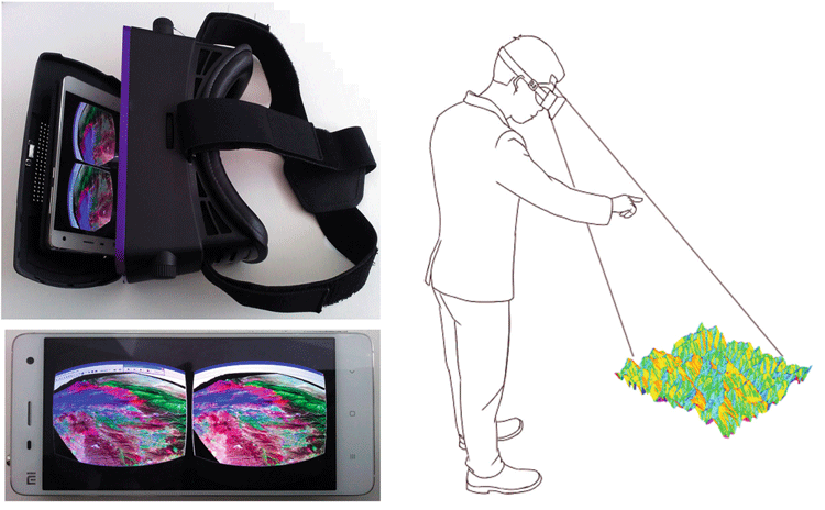
GIS and Virtual Reality
The integration of virtual reality (VR) with GIS is gaining traction in various areas such as urban planning and education.

GIS and Digital Humanities
GIS significantly influences digital humanities with a spatial focus, increasingly important for various humanities scholars.

Information Services and the User Experience in the Geographic Information Community
Members of the geographic information community can be considered heavy users of information services. Geographic information (GI) users are “super-encounterers” ...
Information Needs and Information Seeking Behavior Within the Geographic Information Community
As part of the Professional and Occupational information community category (Hansen 2014), members of the geographic information community can be ...

The Geographic Information Community
At its broadest definition, the geographic information community (GIC) is a community of users who are connected by the common interest in visualizing and analyzing spatial (or geographic) information.

The Role of GIS in Wildlife Research and Conservation
Monitoring and studying wildlife habitats has long been a key focus within GIS.

GIS and Advertising
Advertisers are becoming more sophisticated with the use of GIS as a way to better target their audiences.

Be Aware of the Proposed Geospatial Data Act (GDA) of 2017
The Geospatial Data Act (GDA) of 2017 is being reintroduced in Congress. Passage of this bill would have a severe impact on the GIS industry.

Detecting Spatial Patterns in Drug Abuse With GIS
Drug abuse has been shown to have clear spatial patterns that GIS has helped to demonstrate.

How Agencies Can Harness Geosharing to Improve Infrastructure
How can communities become more engaged with reporting issues with infrastructure? Olivia Harne discusses how an investment in geographical data sharing could be a potential solution.
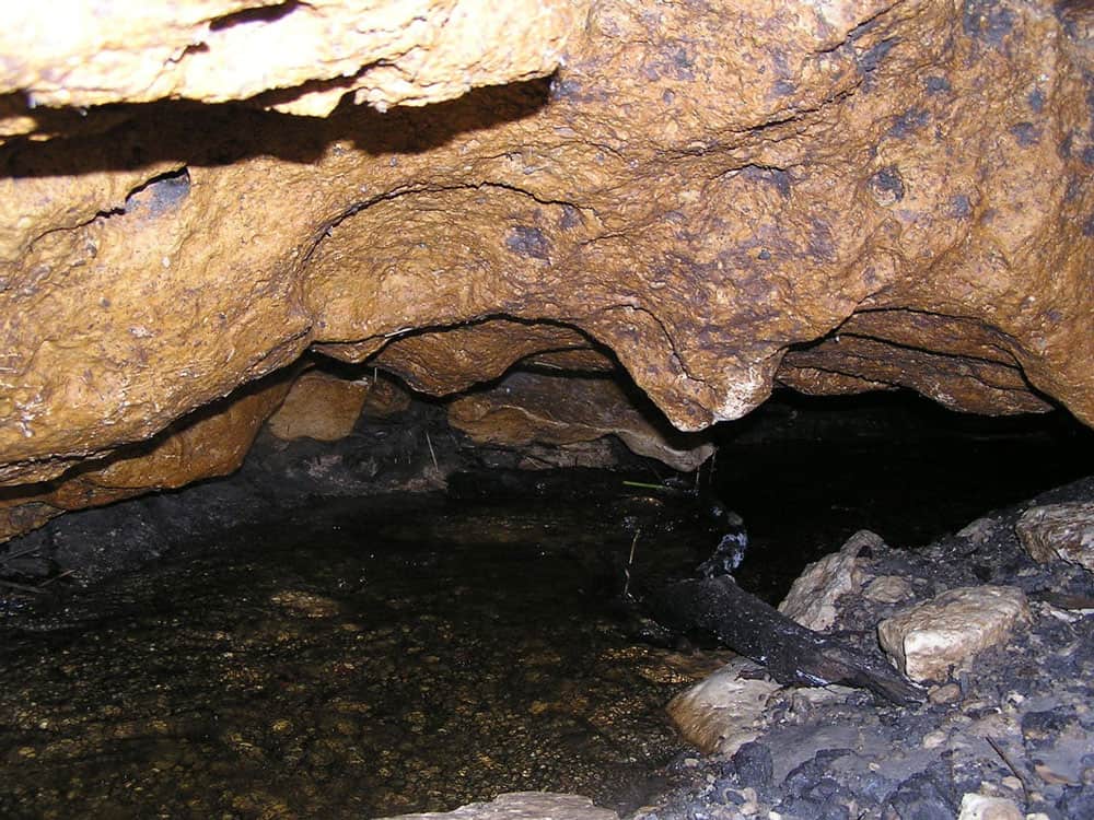
GIS and Karstic Cave Monitoring
GIS and remote sensing have been used to predict likely regions where caves can be found.

Using GIS to Conserve the Greater Sage-Grouse
GIS has emerged as an essential analysis and communication tool for the Oregon BLM in general, and its sage-grouse conservation efforts.

Monitoring Livestock Using GIS
GIS and other geospatial technologies are being used to monitor livestock, understand the role that cattle play in climate change, and estimate biofuel.

Navigation, GIS, and Voice Command
Progress has been made on developing GIS and GPS technology capable of interpreting natural language and voice commands.

The Need For Ethics in GIS
The consideration of a code of ethics in GIS has mostly been overlooked as a critical component in geospatial education and certification.
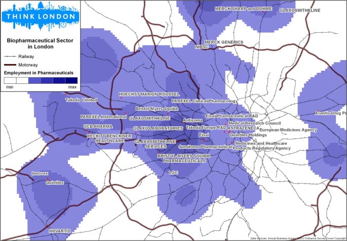
GIS and Entrepreneurs
GIS aids in investment decision-making by unveiling spatial patterns key to entrepreneurial success like labor concentration, knowledge, and opportunities.

Celebrating Valentine’s Day, Geographer Style
What better way for geographers to say "Happy Valentine's Day" than with geography? Nature supplies us with plenty of heart shape topography found around the world. Heart shaped islands, vegetation, and lakes make up this love themed geography article.
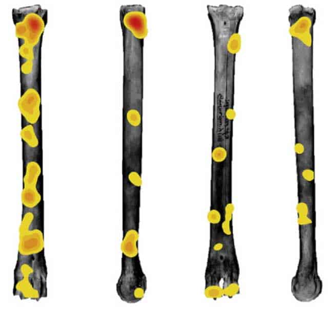
How GIS Helps with Researching Human Evolution
GIS has now provided new avenues of research that has helped physical anthropologists better understand how different hominid species evolve to different environments.
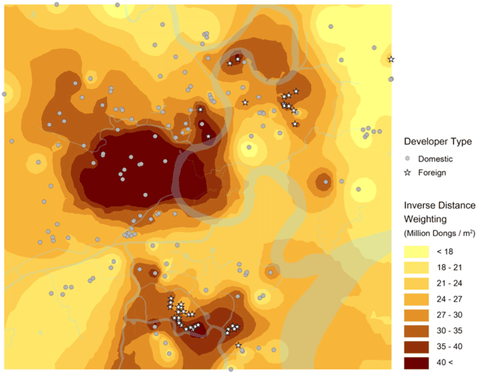
Utilizing GIS for Investment Opportunities
GIS-based spatial understanding can crucially inform where and how to invest in specific markets.
Using GIS in the Insurance Industry
Location has a large impact for the insurance industry, as a variety of natural or even social risks, such as crime, could affect insurance rates for life and property.

The History of Mapping Disease
Cartographies of Disease: Maps, Mapping, and Medicine takes a look at how cartography and GIS have been used to map and combat devastating diseases such as cholera, yellow fever, and Ebola.

Helping Chimpanzee Conservation Efforts with Satellite Imagery
NASA has partnered with the Jane Goodall Institute to provide satellite imagery and the analysis needed to understand where habitat loss is the most extreme to protect chimpanzees in the wild.

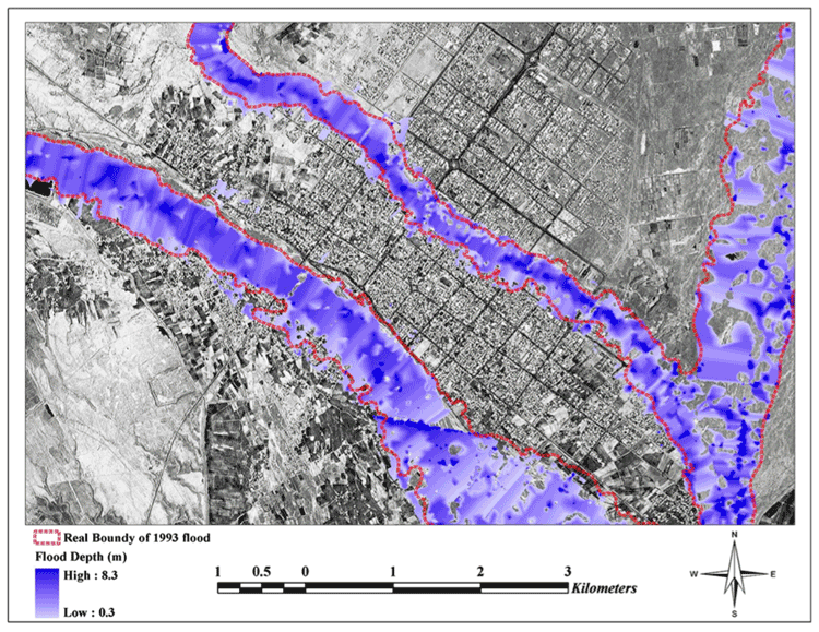
Three Examples of Geospatial Innovation in Emergencies
Bailey Morton outlines three examples of how innovative geospatial analysis can help save lives in emergency situations.

Using GIS to Assess and Mitigate Rail Hazards
GIS has been of interest to rail companies, NGOs, and governments attempting to minimize a variety of hazards that may affect the rail network.