
GIS Industry
Articles about trends and advancements in the geospatial industry.

Make Agile Work for You: Six Practices for Location Based App Development
This article takes a look at the Agile process in use at Timmons Group which focuses on six practices: adaptive planning, iterative development, early delivery, continuous improvement, rapid and flexible response to change, and promoting teamwork.
Where Have You Been? Using GIS to Analyze Residential History and Health Care
Troy Lambert takes a look at how the power of GIS can be leveraged to greatly influence healthcare as we know it.

GIS in Oil and Gas
The Oil and Gas industry is leveraging GIS through a seamless integration of geospatial technologies like UAV, sensors and existing computer systems.

GIS and IoT Business Applications
Augmenting IoT data with interactive GIS mapping can significantly improve understanding of spatial data.

WalMap: The App By Walgreens That Maps Out Community Trends in Real Time
Walgreens uses GIS to power its Flu Index Map, visually tracking flu spread for better healthcare decisions and increased public awareness.
GIS vs. Surveyors Court Case to Start on GIS Day
Instead of celebrating GIS on November 18th, one company will be defending its GIS and GPS services as a case against them will start oral arguments in Pennsylvania.

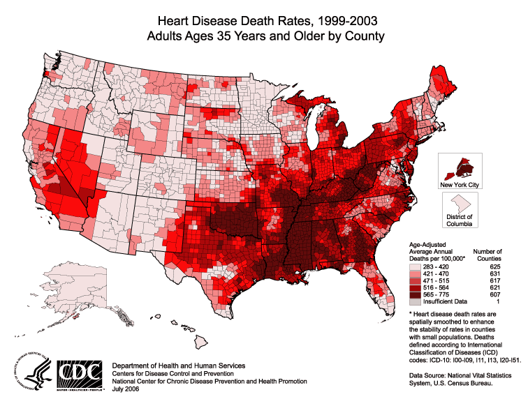
A Brief History of GIS
From the early days in Canada to the high tech world of internet mapping, the field of GIS is older than you may think.
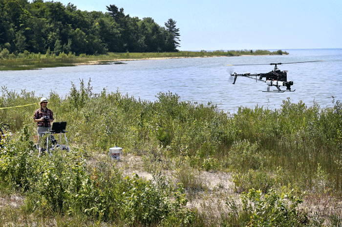
Drones and GIS: A Look at the Legal and Ethical Issues
The ethical and legal issues about gathering geographic data using drones can be divided into four main areas: regulations, privacy, safety, and noise.

Spatial Law and Geospatial Applications
Taking a look at spatial and and geospatial applications, this is the third of a three-article series on Spatial Law that focuses on the issues surrounding spatial technologies, the responsibilities and legalities thereon.

Spatial Law and Geospatial Technologies
Taking a look at spatial and and geospatial technologies, this is the second of a three-article series on Spatial Law that focuses on the issues surrounding spatial technologies, the responsibilities and legalities thereon.

Spatial Law, Policy, and Geospatial Technologies: A Comprehensive Overview
Taking a look at spatial law and its application within GIS is the first of a three-article series on Spatial Law that focuses on the issues surrounding spatial technologies, the responsibilities and legalities thereon.

Abstracts from a Day at the 2015 Esri User Conference
Kristina Jacob, a professional photographer and GIS professional, captured some moments from the 2015 Esri User Conference. The annual conference ...

BIM – Information and Management
Building information modeling (BIM) is a managed approach to the collection, creation, collation and exchange of shared intelligent and structured ...

Geodesign to Create Smarter Cities and Adaptable Landscapes
Nadia Amoroso writes about geodesign and the geodesign technology platform offered by Esri as it pertains to Smart Cities.

Geointelligence – Empowering Geospatial with Intelligence
Geointelligence is the use of GIS and other geospatial technologies to help with defense and military operations.

Defining Waterfall and Agile GIS Project Management Styles
Lowell Ballard, the Director of Geospatial Solutions for Timmons Group, takes a look at effectively engaging clients for GIS projects. ...

How Spatial Big Data Underpins Smart Cities
Underpinning any smart city program is trusted geospatial information; one single source of reliable, location-specific data.

Using Geospatial Technologies to Save the World’s Peatlands
Rezatec has developed “Peat spotter”, a service that uses Earth Observation imagery to locate and create initial mappings of peatlands. This information is enriched with ground data collected by field agents using handheld devices.

Abstract Machine: Applying GIS in the Humanities
In Abstract Machine: Humanities GIS, Charles B. Travis, a senior research fellow at Trinity College Dublin in Ireland, uses case studies from history, poetry, and published works to explore out GIS analysis is used to explore and understand events in literature, history, and culture.
Building Better Maps for the Visually Impaired
For those of us who can see, being able to read a map is something that we take advantage of ...
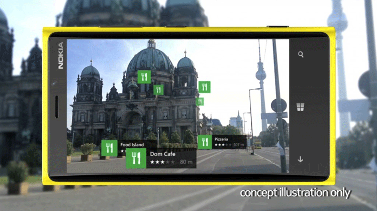
Augmented Reality and the Digital Map Revolution
Groundbreaking technology called augmented reality is affecting digital maps, changing how we find and discover the world around us.

Land Surveying and GIS Revisited: An Unnecessary Drama
Joseph Magnotta presents an opinion piece about the relationship between surveyors and the GIS industry and why it doesn't need to be contentious.

How GIS is Being Used in Conservation Biology
GIS has a central role in analyzing the geographic distribution of endangered species, in measuring and monitoring biodiversity, and in identifying priorities for conservation management.

Four Ways GIS is Being Used to Help Populations Vulnerable to Long Term Climate Change
GIS is changing the way vulnerable populations relate with their natural world and resources to keep ahead of imminent climate changes.

How GIS is Being Used in Real Estate
What do GIS and real estate have in common? They both place a very high importance on location. For real estate ...

How GIS is Being Used to Help Native Americans
Native Americans use GIS for heritage/environmental protection, economic development, education, health, transportation, land use, and resource management.