
GIS Industry
Articles about trends and advancements in the geospatial industry.

Analyzing Risk for Radioactive Materials Using GIS
Earlier GIS studies focused on analyzing safe routes for transporting radioactive materials, while recent ones have quantified the storage risk.

NASA Exploring Using Mini-drones
NASA has gotten in on the drone action themselves, testing unique mini-drones that are manufactured in Sweden.


Using GIS in Landscape Archaeology
Landscape archaeology is a discipline where space is critical to understanding ancient settlements and human use of ancient space. The use of GIS is steadily growing as a tool in this field.

Using UAVs to Map and Monitor Pipelines
Unmanned Aerial Vehicles (UAVs) are currently being used to not only speed up the pipeline routing process but also to make it both safer and more economical.

How GIS Can Help Dentists Find Cavities
GIS is making inroads in dentistry, where dentists now use spatial technologies for diagnosis and dental surgery.

Using GIS in Space Exploration
While we generally think of GIS applied to objects or systems on Earth, GIS has been of great utility for space exploration.

Collecting GIS Data with Drones
Drones are rapidly being adopted as a way to quickly collect aerial imagery and other forms of geospatial data.

Mapping Market Reach
Troy Lambert discusses how colleges can use GIS and mapping technology to better target marketing.

Using GIS to Map Telecommunications
Mapping telecommunication networks is of great importance to both urban and rural regions, particularly as telecommunication networks become even more vital for our daily lives. Terrain, vegetation, urban regions, and other potential interference are often assessed together and GIS tools such as ArcGIS have developed into an industry standard for forecasting cellular tower locations.

GIS and Sustainable Energy
GIS has become a critical planning and management tool for addressing where and how to enable sustainable energy efforts.
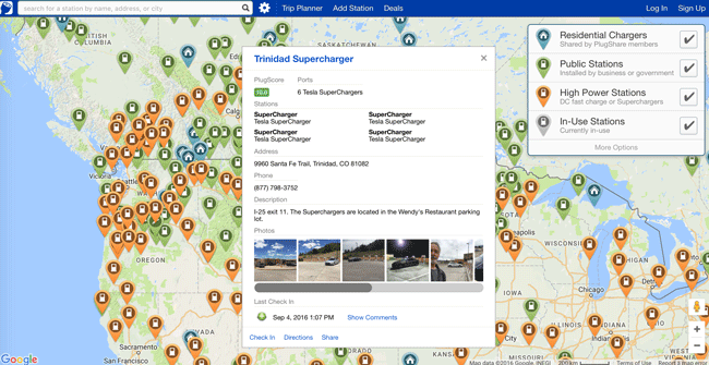
How GIS is Helping Electric Cars on the Road
GIS is playing an important role by helping drivers plan travel that factors in charging stations.

GIS, Pollution, and Health
GIS has been used to assist in showing strong or weak links for given health conditions to different types of pollutants.

How GIS Helps Small Ships Navigate
GIS has been utilized in sailing and other small craft to help navigate not just the location of other vessels but also land features and obstacles that may arise or even cause danger to boats.

GIS and Quick Response Codes
As smart phones and Quick Response Codes (QR codes) have become ubiquitous, it perhaps should not be surprising we are beginning to see applications integrating QR code data with GIS.
GIS and Small Business Planning
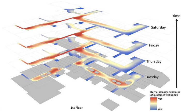
Small businesses increasingly use GIS for spatial analyses like kernel density estimation or Monte Carlo simulation to boost their success.

GIS and Underground Mining
GIS has been utilized to monitor tunnels and areas explored, as it provides both 3D visualization and abilities to integrate various sets of data for visual and quantitative analysis.

Using GIS During Fire Season
Every year, GIS users get better at assembling data and creating meaningful maps that help decision makers predict fires, set fire risk levels, and deploy assets in the most efficient manner possible.

GIS and Human Anatomy
Mapping and monitoring the human body in real time using GIS is one area of great opportunity for medical and healthcare professionals.

Using an Interactive Web and Desktop Based Spatial Technology to Monitor Performance of Public Health Outcome in Developing Countries
FGIS (FHI Geographical Information System) is browser-based interactive data visualization and mapping application that runs on the FHI360 Nigeria intranet, an online resource that serves as a common framework for sharing geographic resources about FHI360 programs in Nigeria.

Is Sexism a Problem in GIS?
This article takes a look the state of sexism in GIS and reports how those working in the field have spoken about how sexism has impacted them.

Volunteer to be a Digital Humanitarian and Help With Mapping Projects
The Humanitarian OpenStreetMap Team is able to provide mapping services in large part due to its army of volunteers. Find out ways that you can get involved with HOT.

Garmin Acquires DeLorme
Garmin announced the news on February 11, 2016 that it had signed a purchase agreement to acquire DeLorme.

How GIS Supports the Planning and Development of Smart Cities
The Smart City model uses robust GIS for building urban resilience. The GIS framework seamlessly integrates with other technologies supporting visualization and analysis in real time. This becomes the mainstay of ‘smart’ management providing resource optimization, open and participatory governance and efficient management of city infrastructure.

How to Implement an Effective UX Design Strategy
A designer’s voice on the relevance of User Experience (UX) design in modern GIS application development.

Line of Sight: Track the Real Time Locations of Satellites
Line of Sight is an online map application that tracks where each and every satellite is above the Earth in real time.