
Like many location-based companies, the use of GIS is not only handy, it can be necessary to make the most informed decisions. WalMap, a new interactive application accessible from mobile devices like the iPad, are allowing all tiers of this $76 billion company to ensure market strategies are informed and responding accurately to variations across geographic locations. With 8,300 stores between the United States and Puerto Rico, the company sits on a vast amount of health and community-related GIS data.
Using GIS to track flu prescriptions
This system has enhanced Walgreens’ response to stark changes and allows the firm to be proactive. If there is a spike in the number of flu prescriptions in a region, for example, the workers at that location can order more flu vaccinations as a preventative measure.

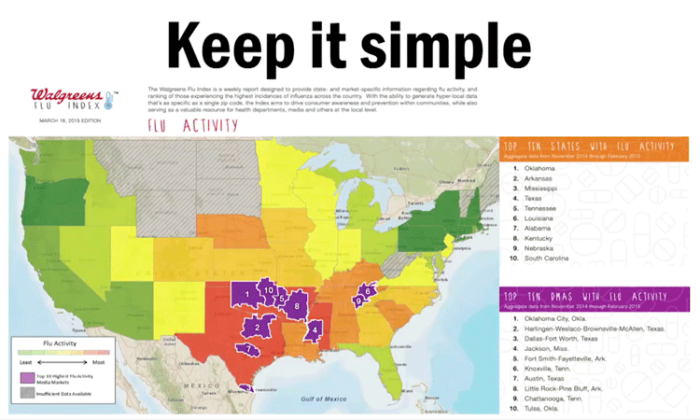
Walgreens has been able to create a Flu Index. Walgreens’ Flu Index Map is a dynamic, interactive tool designed to monitor the incidence of influenza-like illnesses across the United States. Developed by the pharmacy chain Walgreens, the map compiles and analyzes retail prescription data for antiviral medications used to treat flu symptoms. This allows it to generate near real-time reports on flu activity. The map is color-coded, indicating the severity of flu cases in various regions, and is updated regularly to reflect the latest data.
When company executives are planning internally or with distributors, they can also discuss their needs in real-time, with geographically specific numbers. Previously, store managers and executives alike would have to print copies of the mapped data in order to utilize it; now it can be accessed from nearly anywhere.
WalMap was created in partnership with Esri, which Walgreen has been working with since 2000. Since then, Walgreens has used GIS extensively, but predominantly in site selection, competitor analysis, and mapping demographics. Now their wide-reaching internal database combined with Esri’s proprietary data allows for millions of maps to be generated.
These data in conjunction has allowed Walgreens to apply it beyond the scope of their own work. In some cases, they have been able to notice crime trends and assist law enforcement in mitigating these increases. With such comprehensive data now at their finger-tips, GIS continues to optimize not only the company’s well-being, but also the communities in which Walgreens serves.
Learn more about Walgreen’s use of GIS:

Reference
Savvy businesses share a secret. (2015, September). Esri ArcWatch. https://www.esri.com/about/newsroom/arcwatch/savvy-businesses-share-a-secret/