
The geospatial career choice most often stems from college degrees in Geography, Environmental studies or Civil Engineering. For the more geo-aware, it may be a deliberately chosen trajectory through University and community engagements. However, confusion and lack of awareness is often a barrier to the pursuit of a profession in this space.
This article aims to shed more light on a discipline that is increasingly embracing new technologies within the spatial fold.
As application areas of GIS increase, a seamless merging of knowledge base, the sciences and the technologies, is called for. A blend of degrees and certifications in various subjects has become the norm.
This means, one can study Marine Science or Information Technology, and migrate laterally to a ‘location-driven’ industry.
For an idea of how to pursue a profession in the geospatial landscape while incorporating field of interest, here is a list of disciplines one may choose to study. This is the fountainhead of a ‘spatially driven’ career roadmap.
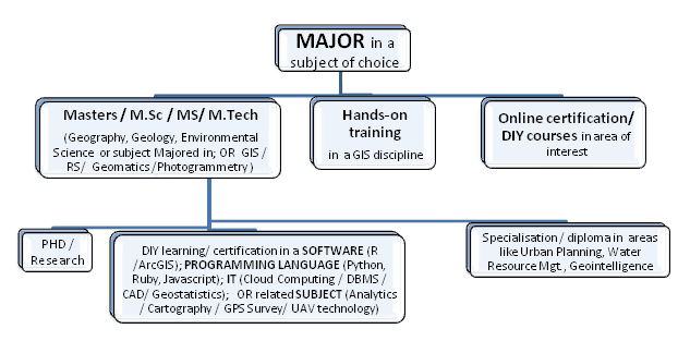
Disciplines that lead up the GIS path

The Geospatial Learning Trajectory
Although specializations and subject expertise has become the order of the day, the GIS roadmap offers a wonderful opportunity of learning on the fly.
You can choose to add-on to your studies and skill sets while continuing to work, volunteer or engage in crowdsourced mapping.
Geospatial Career Scope
- Community engagements
- Disaster management / First responder initiatives
- Government departments / Local councils
- Industry – Utilities (Water, Power), Defense, Intelligence, Consultancy, Oil and Gas, Social Sciences, Health, Public safety, Geology, Environment, Space / Satellite, Geo Analytics, Location Intelligence, Marine Sciences, Urban planning, etc
- Organizations like NASA, URISA, GIS Corps
- Research
- Analytics firms (leveraging location intelligence)
- Mapping portals
- Non profits
- Education and training
- Start-ups
- Software development
- Self designed career paths
- Consulting / Management Consulting