
Sangeeta Deogawanka

How GIS Helps Drive Hydrography Data
There are more high resolution maps of the Moon and Mars, than the seafloor.

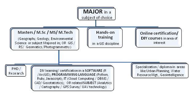
Making a Career in Geointelligence
Sangeeta Deogawanka talks about building a career in Geointelligence, covering areas like security, intelligence, policy analysis, and first response.

How GIS Supports the Planning and Development of Smart Cities
The Smart City model uses robust GIS for building urban resilience. The GIS framework seamlessly integrates with other technologies supporting visualization and analysis in real time. This becomes the mainstay of ‘smart’ management providing resource optimization, open and participatory governance and efficient management of city infrastructure.

GIS in Oil and Gas
The Oil and Gas industry is leveraging GIS through a seamless integration of geospatial technologies like UAV, sensors and existing computer systems.
The Many Aspects of a Career in Geospatial
Sangeeta Deogawanka takes a look at the GIS/geospatial arena that is increasingly embracing new technologies within the spatial niche.

Spatial Law and Geospatial Applications
Taking a look at spatial and and geospatial applications, this is the third of a three-article series on Spatial Law that focuses on the issues surrounding spatial technologies, the responsibilities and legalities thereon.

Spatial Law and Geospatial Technologies
Taking a look at spatial and and geospatial technologies, this is the second of a three-article series on Spatial Law that focuses on the issues surrounding spatial technologies, the responsibilities and legalities thereon.

Spatial Law, Policy, and Geospatial Technologies: A Comprehensive Overview
Taking a look at spatial law and its application within GIS is the first of a three-article series on Spatial Law that focuses on the issues surrounding spatial technologies, the responsibilities and legalities thereon.

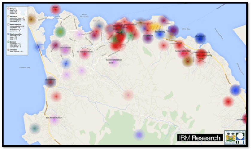
How Crowdsourced Mapping is Supporting Relief Efforts in Nepal
When Nepal was hit by an earthquake of a icagnitude 7.8 on 25 April 2015, it was a disaster, unprecedented ...

Geointelligence – Empowering Geospatial with Intelligence
Geointelligence is the use of GIS and other geospatial technologies to help with defense and military operations.

Learn about GIS in the Cloud
GIS technology and processing in the cloud is on the way to becoming the next big trend. The various functionalities of the cloud can be suitably tailored to fit into an organization’s geospatial workflow.

Empowering GIS with Big Data
Analysis of Big Data in a geographic context has empowered organizations and businesses faced with huge amount of data and diverse technologies. The integration of maps with multiple layers of information tells the full story behind the data. Trends and patterns are revealed. Queries are answered and new questions are also addressed. At the same time, predictive modeling on massive datasets help drive accurate decision-making, profitability and effective resource management.

How GIS is Being Used to Help Native Americans
Native Americans use GIS for heritage/environmental protection, economic development, education, health, transportation, land use, and resource management.