
GIS Learning
Resources covering the basics of GIS. Tutorials for learning GIS, geospatial community, and geographic concepts.
Geography and GIS Glossary
This Geography and GIS glossary provides definitions for terms related to geographic information systems (GIS), cartography, remote sensing, and other ...
How to Find the URL to an ArcGIS Online Web Map and Add it to QGIS
Learn how to find URLs for older feature and map servers hosted on ArcGIS Online so they can be added to QGIS.

5 Ways GIS Users Can Broaden Their Geospatial Skills
From programming and remote sensing to volunteering and networking, there are many ways to build new geospatial skills.

Learn How to Georeference a Map in QGIS Using GIS Data
Learn how to georeference scanned maps in QGIS using reference GIS data and control points when no coordinate grid is available.

Change Detection Using Kernel Density Analysis in ArcGIS Pro
This GIS tutorial provides step-by-step instructions for how to use two point datasets to detect changes in ArcGIS Pro using kernel density.

Teaching GIS to Kids to Help Them Learn Spatial Skills
Tips and resources to help you get started with teaching your children about GIS and mapping.

Georeferencing Scanned Maps in QGIS Using Graticules
This GIS tutorial teaches you how to assign geographic coordinates to a scanned map in QGIS using a process known as georeferencing.

Introduction to GIS
GIS is a technological field that incorporates geographical features with tabular data in order to map, analyze, and assess real-world problems.

Using interpolation to create a surface layer with contours in QGIS
This GIS tutorial shows you how to find elevation data points and create a surface layer and contours using QGIS.

GIS User Groups in the United States
GIS user groups are a great way to network with other GIS professionals on a local level. GIS user groups commonly are organized at the regional level.
GIS Tutorials
Online GIS tutorials from Geography Realm for mapping and data analysis.

Create a Bathymetric Map Using ArcGIS Pro
This step-by-step GIS tutorial shows you how to create a bathymetry map using ocean data from GEBCO.
GIS and Cartography Quotes
Looking for a memorable GIS quote? Check out this growing collection of interesting and notable quotes relating to GIS, cartography, maps, and geography.
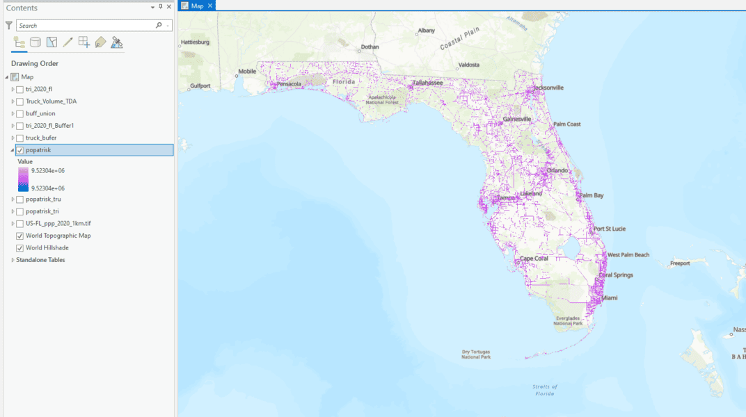
How to Use ArcGIS Pro to Determine the Population Impacted by Air Pollution
Learn to estimate air pollution's impact on people with geospatial methods using ArcGIS Pro and data from Toxic Release Inventory, Worldpop, and ArcGIS Hub.
Free Ways to Learn QGIS
If you want to start learning how to use QGIS, a free and open source GIS software package, there are some excellent free resources out there.

Networking in GIS: Peer-to-Peer Support in the GIS Community
List of peer-to-peer resources that GIS professionals can tap into for assistance with their technical queries and to connect with others in the field.
Learn GIS for Free
There are a few online options to learn GIS for free. Take advantage of resources that provide you access to free courses from some of the world's best universities and institutions.

How to Learn GIS
There are many ways to learn GIS. Listed here are guides to learn GIS in a classroom, online, or through self-guided methods.

Finding the Right GIS Program
Choosing the right GIS educational program to set you on the right path towards a GIS career, so be sure to consider all your options before making a decision.

A Guide to Understanding Map Projections
Map projections are techniques used to transform the Earth's three-dimensional surface onto a two-dimensional plane, inevitably introducing some distortion in area, shape, distance, direction, or scale.
GIS 101: Learn About GIS
This GIS 101 page is the launch page for accessing information about GIS and geospatial technologies on GIS Lounge.

What is the Difference Between GIS and Geospatial?
There are differences in what the terms GIS and geospatial mean.
Free GIS Books
Most of these free GIS books are available in downloadable PDF format and can be read from a computer or on an eBook reader.
GIS Reference Books and Materials
Here are some books and GIS reference resources that are valuable for both the novice and seasoned GIS user.
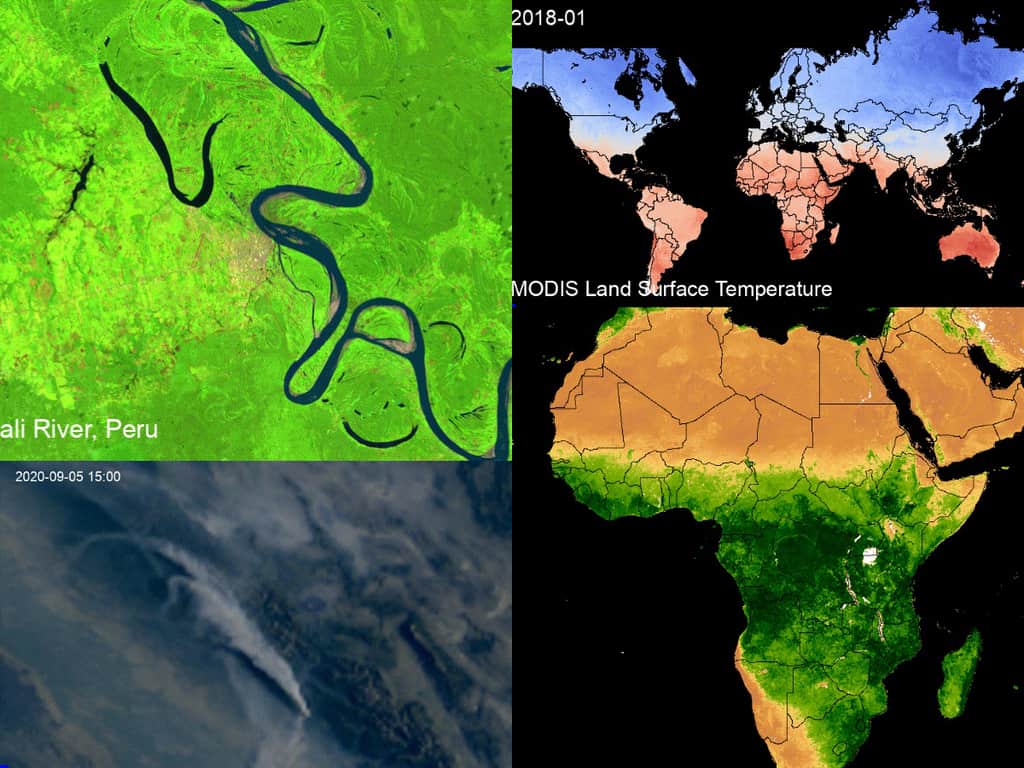
How to Create a Time-lapse of Satellite Imagery With Google Earth Engine and Streamlit
Qiusheng Wu explains how to make a 60-second satellite timelapse of any location on the globe.
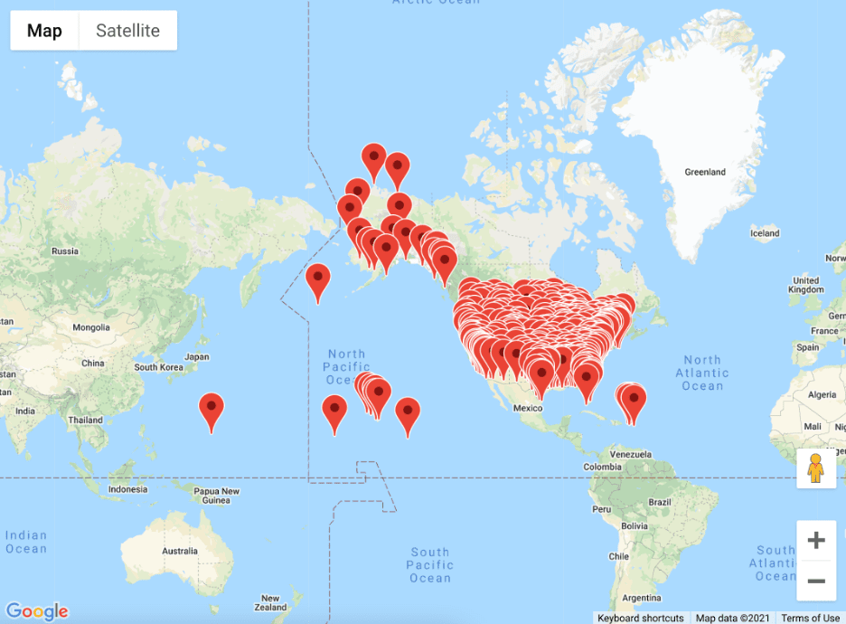
A Guide to Building Interactive Google Maps with R Shiny
Dario Radečić demonstrates how to build interactive Google Maps with R, and how to include them in R Shiny dashboards.