
GIS Learning
Resources covering the basics of GIS. Tutorials for learning GIS, geospatial community, and geographic concepts.

How to Geocode Addresses Using QGIS
If you have a CSV formatted file containing addresses, you can take advantage of QGIS to map out those addresses. This article contains step by step instructions for geocoding addresses using QGIS.

Seafloor Mapping Techniques
Today, seafloor mapping is essentially a form of remote sensing that uses similar concepts and applications to satellite-based systems, albeit adapted to the complex environment of the oceans.

How to Save a Selection as a New File Using QGIS
Learn how to save a selection from a GIS dataset to a new GIS file using QGIS with this quick video tutorial.

Using GIS to Help Locate Missing Persons
Andy Berry, Vice President EMEA at Pitney Bowes Software, discusses the important role of geospatial data as applied by the New South Wales police in Australia, in Search and Rescue.

These Two ArcGIS Books are Free from Esri
Esri offers two free ArcGIS books: '10 Big Ideas about Applying The Science of Where' & 'Instructional Guide for The ArcGIS Imagery Book'.

The Use of Python in GIS
Python today is by far the most widely used language by GIS users and programmers.

Data Driven: GIS Guiding the Future
Mapping has always been data driven, and the more data we gather, the more important practical visualization of that data becomes.

Using Terra and Aqua Layers with Open Satellite Map
Georgy Potapov of OpenWeatherMap introduces the availability of low resolution MODIS imagery from Aqua and Terra satellites via the VANE platform.
Using GIS to Study Plant Behavior
The application of plant biology with GIS has potentially important implications for the study of plant behavior affecting important factors such as the Earth’s climate and agricultural supplies.

Using Census Data to Define US Commuter “Megaregions”
Researchers analyzed Census data to map out commuter megaregions in the United States.

First Data Released From ESA Satellite Sentinel 3-A
The European Space Agency and Eumetsat have just released the first data from their new satellite platform, Sentinel 3-A. This groundbreaking new Earth observation platform can monitor a wide range of Earth systems, and will play a vital role in understanding our planet into the future.

How GIS is Helping Gardening
GIS is used in gardening to manage and comprehend the spatial layout of plants, from research and public gardens to home and backyard settings.
Teaching GIS in Elementary School
Research on how to best implement GIS education for K-12 has looked at the use of web-based GIS and data that is understandable at different levels.

How GIS Helps Drive Hydrography Data
There are more high resolution maps of the Moon and Mars, than the seafloor.

How GIS is Used to Understand History
Historical geography is one area that has applied GIS to understand outcomes of battles, why cities were built in given locations, and using ancient technologies to understand length and difficulty of travel at different times of the year.

Real-time Collaborative GIS
Real-time collaborative GIS (RCGIS) enables users, from domain experts to common citizens, to collaborate on given issues and share data easily through a distributed framework.

4D GIS and Prediction
For the last two decades, GIS technologies have increasingly been used to incorporate not only spatial relationships but also analyzing and visualizing space across time. Spatial-temporal GIS, or 4D GIS, has, in particular, become essential in areas where GIS is needed for predicting dimensions across time.

GIS and NoSQL Databases
Relational databases present some limitations to scaling, preventing or limiting the applicability of big data and real-time data problems utilized within GIS. More and more GIS software companies and developers are adopting NoSQL formats where data retrieval is generally faster and easier to structure. NoSQL also facilitates analysis and integration within a variety of tools, which is why open source GIS has proven to be the most useful arena for NoSQL databases.

GIS and Natural Language Processing
Within GIS, natural language processing can be utilized for spatial understanding of where events, places, or people may relate to a given phenomenon.

New Earthquake Maps from the USGS Also Factor Human Activity Induced Causes
The United States Geological Survey has created a new map that highlights where natural and man-made earthquakes could cause damage around the country.

Google’s PlaNet: Geolocating Photos Using Artificial Intelligence
Google and researchers at the RheinischWestfälische Technische Hochschule Aachen University have developed an artificial intelligence system capable of identifying locations more consistently accurately than a human is able to do.

Take Map Design to the Next Level with QGIS
QGIS Map Design provides step-by-step instructions covering both basic styling and labeling and advanced cartographic techniques such as illuminated contours and dynamic masking.
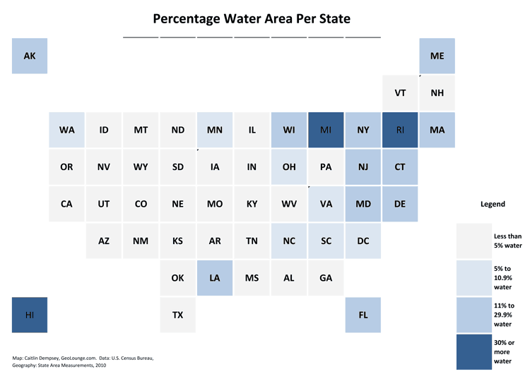
How to Make a Tile Grid Map Using Excel
Step-by-step tutorial for creating a tile grid map of the United States using Excel.

Orbital Insight Shows How Artificial Intelligence (AI) Can Be Used to Study Images from Space
Orbital Insights has developed a “deep learning” processes which uses artificial intelligence to pull data from satellite imagery.

David or Goliath: Establishing Your Mobile GIS Portfolio
Lowell Ballard, the Director of Geospatial Solutions for Timmons Group, discusses the David versus Goliath approach in developing robust and full-featured versus smaller more focused mobile GIS applications.

Mapping County Demographic Data in R
Learn how to map US County demographic data in R in this article by Ari Lamstein.