
GIS Learning
Resources covering the basics of GIS. Tutorials for learning GIS, geospatial community, and geographic concepts.

Neocartography Can Be Beautiful, Cartography Can Be Fast
Nicolas Regnauld, Product Manager at 1Spatial discuss the debate about neocartography versus traditional cartography and the evolution towards creating more intelligent automation tools for creating maps.

Creating Dynamic Maps in QGIS Using Python: QGIS Python Programming CookBook
Learn how to use Python to create dynamic maps in QGIS with this free preview chapter of QGIS Python Programming CookBook. With ...

Tools: QGIS Python Programming CookBook
Learn how to work with map tools in QGIS using Python from this section as part of this preview chapter, Creating Dynamic Maps from QGIS Python Programming CookBook.
Labeling and Map Transparency: QGIS Python Programming CookBook
Learn how to label features and set map transparency in QGIS using Python from this section as part of this preview chapter, Creating Dynamic Maps from QGIS Python Programming CookBook.

Adding Real-Time Weather Data from OpenWeatherMap: QGIS Python Programming CookBook
Learn how to add real-time weather data from OpenWeatherMap in QGIS using Python from this section as part of this preview chapter, Creating Dynamic Maps from QGIS Python Programming CookBook.
Bing Aerial Image Service: QGIS Python Programming CookBook
Learn how to use the Bing Aerial Image Service in QGIS using Python from this section as part of this preview chapter, Creating Dynamic Maps from QGIS Python Programming CookBook.
Using the OpenStreetMap Service: QGIS Python Programming CookBook
Learn how to use the OpenStreetMap Service in QGIS using Python from this section as part of this preview chapter, Creating Dynamic Maps from QGIS Python Programming CookBook.

Layer Symbols: QGIS Python Programming CookBook
Learn how to symbolize layers using SVG and pie charts in QGIS using Python from this section as part of this preview chapter, Creating Dynamic Maps from QGIS Python Programming CookBook.
Scale and Layer Visibility: QGIS Python Programming Cookbook
Learn how to set up scale-dependent layer visibility in QGIS using programming from this section as part of this preview chapter, Creating Dynamic Maps from QGIS Python Programming CookBook.
Map Bookmarks: QGIS Python Programming CookBook
Learn how to create and navigate to map bookmarks using python in QGIS as part of this preview chapter, Creating Dynamic Maps from QGIS Python Programming CookBook.

Symbolizing Vector and Raster Layers: QGIS Python Programming CookBook
Learn how to symbolize vector and raster layers in QGIS using programming from this section of the preview chapter, Creating Dynamic Maps from QGIS Python Programming CookBook.
Accessing the Map Canvas, Changing Map Units, and Iterating over Layers
Learn how how to control an object through the Map Canvas, change map units, and how to loop through map layers in QGIS using Python. From: Creating Dynamic Maps from QGIS Python Programming CookBook takes a look at

Free Preview of Mastering QGIS
Mastering QGIS is designed to bring users who want to go beyond the basics of QGIS to an advanced level ...

Working with Coordinate Reference Systems: Mastering QGIS
This section of the free chapter preview of Mastering QGIS looks at working with coordinate systems in QGIS. Mastering QGIS is designed to bring users who want ...

Styling Vector and Raster Data: Mastering QGIS
This section of the free chapter preview of Mastering QGIS looks at styling vector and raster GIS data in QGIS. Mastering QGIS is designed to bring ...

Adding Functionality with Plugins: Mastering QGIS
This section of the free chapter preview of Mastering QGIS looks at using plugins to extend the functionality of QGIS. Mastering QGIS is designed to bring ...

Composing Maps: Mastering QGIS
This section of the free chapter preview of Mastering QGIS looks at making maps in QGIS. Mastering QGIS is designed to bring users who want to go ...

Editing Data: Mastering QGIS
This section of the free chapter preview of Mastering QGIS looks at editing GIS data in QGIS. Mastering QGIS is designed to bring users who want to ...

Working with Tables: Mastering QGIS
This section of the free chapter preview of Mastering QGIS looks at working with tables in QGIS. Mastering QGIS is designed to bring users who want ...

Loading Data: Mastering QGIS
This section of the free chapter preview of Mastering QGIS covers loading different data types into QGIS desktop. Mastering QGIS is designed to bring users who want ...

How Crowdsourced Mapping is Supporting Relief Efforts in Nepal
When Nepal was hit by an earthquake of a icagnitude 7.8 on 25 April 2015, it was a disaster, unprecedented ...
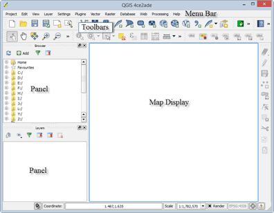
Tour of QGIS: Mastering QGIS
This section of the free chapter preview of Mastering QGIS covers the graphical user interface components of both QGIS Desktop and QGIS Browser. Mastering QGIS is ...
QGIS Download and Installation: Mastering QGIS
This section of the free chapter preview of Mastering QGIS covers downloading and installing QGIS. Mastering QGIS is designed to bring users ...
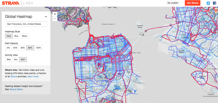
Creating a Global Heat Map from 41.5 Million Runs
Strava, a GPS running and biking application, recently released a detailed global heat map of popular routes across the globe. The map contains over 160 million activities with 375,000,000,000 data points.


GIS Tutorial for Python Scripting
GIS Tutorial for Python Scripting is a new release from Esri Press. This workbook contains hands-on programming exercises to familiarize GIS users ...