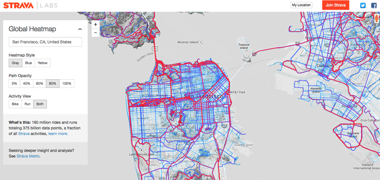
If you are looking for a new running or biking route, Strava has made it easy to discover different places with their new global heat map. Strava, a GPS running and biking application, recently released a detailed global heat map of popular routes across the globe. The map contains over 160 million activities with 375,000,000,000 data points, an engineering marvel that could have many benefits not just for recreationists but for the improvement of cities and communities.
Strava’s Route Builder already collects data tracked by GPS, and this data provides the routes for millions of runners and cyclists that use the application. However, Strava also wanted to see what would happen when they displayed all this information on a map. The result was an eye-opening and an entertaining look at the most popular running and biking routes around the world. Some groups are even using the data in ways that Strava has not anticipated.
To access the maps, users simply zoom in on a particular area of the globe and can toggle between running and biking routes. The brighter a route is, the more popular it is. Of course, major cities are some of the brightest areas on the map. New York City’s Central Park and San Francisco’s Golden Gate Park stand out as well as areas around Iten, Kenya. When an area located away from major urban areas is a hot spot, however, this is also an indicator of an excellent place to run or bike. One example of this would be Idaho’s City of Rocks National Reserve.

Moreover, this map can help users find routes that are not as popular when they want to get off the beaten path as well as discover which trails might be not runnable. Runners and cyclists can find less obvious places to run and bike. Anyone zooming in on Issaquah, Washington, for instance, would see that Cougar Mountain Regional Wildland Park is a must see.
The good news is that Strava’s Global Heatmap is continually being updated. It is brought up-to-date every May and October. The most recent version contained over 41.5 million runs. Besides helping recreationists discover new routes, the map is helping to improve the world in other ways. The map can show particular spots that are not only in high use but are in conflict with traffic or other hazards. It could help improve the running, biking, and walking experiences in many communities.
References:
“Strava’s Heatmap Reveals Where Runners Are.” http://www.runnersworld.com/general-interest/stravas-heat-map-reveals-where-runners-are
“What do 220,000,000,000 GPS Data Points Look Like?” http://engineering.strava.com/global-heatmap/
