
big data

Big Data and Animal Migration
Scientists are using big data methods combined with modern GPS tracking and machine learning to enhance their understanding of global animal migration patterns.

Startups and the Future of Spatial Analysis
A growing number of startups are developing new approaches to advanced spatial analysis for everyday solutions across many fields and industries.

Detecting Flooded Roads From Satellite Imagery
Mapping flood damage by manually examine imagery is a time-intensive and expensive process. New, automated methods using satellite data that compare pre and post-flood conditions are being developed.

Data Driven: GIS Guiding the Future
Mapping has always been data driven, and the more data we gather, the more important practical visualization of that data becomes.

Mapping Billions of Data Points in Milliseconds
With its GPU power, MapD can process and map billions of data points in milliseconds.

Using Song Meters to Count Frog Populations
Conservationists use cameras, acoustic sensors, and audio recording devices to count the red-legged frog in Watsonville Slough, Santa Cruz County.

Open Source Big Spatial Data with GeoMesa
Bob DuCharme, a technical writer with CCRi, writes about how open source GeoMesa can help users with managing large spatio-temporal datasets. GeoMesa can stored petabytes of GIS data and serve up tens of millions of points in seconds.

Big Data, GIS, and Bikes
The Oregon Department of Transportation (ODOT) has set a precedent for public agencies across the country with the purchase of ...
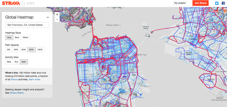
Creating a Global Heat Map from 41.5 Million Runs
Strava, a GPS running and biking application, recently released a detailed global heat map of popular routes across the globe. The map contains over 160 million activities with 375,000,000,000 data points.

How Spatial Big Data Underpins Smart Cities
Underpinning any smart city program is trusted geospatial information; one single source of reliable, location-specific data.
Empowering GIS with Big Data
Analysis of Big Data in a geographic context has empowered organizations and businesses faced with huge amount of data and diverse technologies. The integration of maps with multiple layers of information tells the full story behind the data. Trends and patterns are revealed. Queries are answered and new questions are also addressed. At the same time, predictive modeling on massive datasets help drive accurate decision-making, profitability and effective resource management.

Can Spatial Big Data Build a Better Everyday Life?
Mike Sanderson, the Director of Strategy at 1Spatial, provides a perspective piece on the rise of big spatial data and the importance of being able to base management decisions on correct real-world data.