
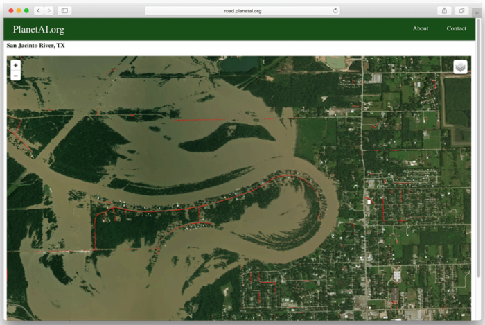
Recovery from flood disaster often means assessing and understanding the scope of a disaster so that an appropriate response for each region can be planed, where resources needed can be better planned. Traditionally, airplanes would be dispatched to monitor areas affected, including flooded roads and other vital infrastructure that can affect or delay recovery or even create a bigger problem for residents and industry. Furthermore, flooding along roads are often a leading cause of death from major weather events. New, automated methods using satellite data, however, could minimize monitoring costs, while also allowing adequate preparation to floods to be undertaken.
Geospatial Analysis of Flooding
Using satellite data, image segmentation using convolutional neural networks (CNN) has been one deep-learning technique that allows the analysis of pre-flood roads and regions to be then compared to the same road segments during periods of flooding. The use of historical and live data allow the CNN algorithm to then detect anomalies from a pre-flood stage through differences noticed between the flooded and non-flooded imagery along road segments. These differences are quickly classified and identified. Models and assessment could then look at how specific roads affected could impact the wider region and people if the road remained flooded. More refined analysis could even estimate the degree of flooding, whether minor or major. The U-Net model has been demonstrated, which was initially developed for medical imaging, to be a highly useful model for this type of segmentation by detecting imagery anomalies from a given baseline, which in this case are pre-flooded roads.[1]

Other applied methods have also included change detection algorithms that sense differences in a defined area. Similar to a CNN, classification of what is flooded and what is not flooded on training imagery can help in automating what is flooded in a given image when new images are received. In this case, SAR satellite data are used as simulator which is then applied to LiDAR data to create maps that have shadowing that are positioned to allow double scattering curves. Variations in the curves allow change detection to demonstrate where flooding is occurring.[2]
Flood Mapping with Synthetic Aperture Radar (SAR) Using Change Detection
In fact, for built environments such as urban regions, high resolution Synthetic Aperture Radar (SAR) data have proven very useful for change detection techniques for identifying urban roads flooded. One problem is that buildings can obscure what is flooded versus other features, where shadowing or other built features may interfere with imagery and image detection approaches. Using backscatter thresholding and region growing along with change detection could help alleviate identification problems and improve accuracy of identifying flooded areas.[3]
While much progress has been acheived in automatically detecting and classifying flooded roads in urban and non-urban context, there is still a lot of work to do in getting these data to disaster management officials when they need it. Big data and emergency response initiatives utilizing satellite data are beginning to change this. Initiatives, including using European-based imagery services, are now trying to use data, such as SAR, for regional and global scale emergency response by making available optimized and data classified to detect, among other disasters, flooding in key areas. This includes roads and other vital infrastructure affected by weather events.[4]
Automated flood detection is critical as part of wider infrastructure monitoring. In particular, as wide areas are more easily covered by high resolution satellites, automated classification and detection will enable emergency response officials to better and more rapidly plan their responses. The aim is to also minimize resource costs in managing a given response. The use of new CNN and change detection algorithms may help achieve this, but data also need to be increasingly shared after automated processing.
References
[1] For more on the CNN algorithm used to detect flooded roads, see: https://opendatascience.com/blog/deep-learning-for-disaster-recovery-automatic-detection-of-flooded-roads/.
[2] For more on the change direction and double scattering used in flood detection, see: Mason, D. C., Giustarini, L., Garcia-Pintado, J., & Cloke, H. L. (2014). Detection of flooded urban areas in high resolution Synthetic Aperture Radar images using double scattering. International Journal of Applied Earth Observation and Geoinformation, 28, 150–159. https://doi.org/10.1016/j.jag.2013.12.002.
[3] For methods on improving change detection for flooded areas, see: Giustarini, L., Hostache, R., Matgen, P., Schumann, G. J.-P., Bates, P. D., & Mason, D. C. (2013). A Change Detection Approach to Flood Mapping in Urban Areas Using TerraSAR-X. IEEE Transactions on Geoscience and Remote Sensing, 51(4), 2417–2430. https://doi.org/10.1109/TGRS.2012.2210901
[4] For more on ‘Big Data’ initiatives to share satellite data that can be used by disaster managers, see: Huber, C., Clandillon, S., Martinis, S., Twele, A., Plank, S., Maxant, J., … May, S. (2016). Improving the extraction of crisis information in the context of flood, landslide, and fire rapid mapping using SAR and optical remote sensing data (pp. 5781–5784). IEEE. https://doi.org/10.1109/IGARSS.2016.7730510.