
Mark Altaweel

Role of GIS in Renewable Energy Planning
Researchers use GIS and climate models to map optimal renewable energy sources, addressing challenges of dynamic energy potentials.

The Recreational Value of Nature and Wildlife
Measuring the economic benefits of wildlife and outdoor areas supports conservation with tools like the NPS Visitor Spending Effects.

How Mapping Mangrove Species Can Help With Coastal Erosion Mitigation
Species-specific mangrove maps aid conservation by targeting protection efforts and resources against storm surges and coastal erosion.

Mapping Coral Reef Health with Sound
Scientists used artificial intelligence and passive acoustic monitoring to assess coral reef health by analyzing the sounds of the ocean.

Using GIS to Design Child-Friendly Cities
Using GIS, cities can design child-friendly pedestrian pathways that prioritize children's interests and safety, promoting urban living and sustainability.

Urban Tree Canopy Affects How Heat Stress Impacts Residents
Minority and low-income neighborhoods have 11% fewer trees, are 1.5°C hotter, and have 14% more impervious surfaces than wealthier, whiter areas.

Forecasting Phytoclimates
A study of 135,153 vascular plant species predicts that by 2070, 33-68% of land on Earth will experience significant phytoclimate changes.

Human-Driven Extinction of Birds
Researchers using models and historical records estimate that up to 11% of all bird species have gone extinct since the Late Pleistocene.

Weather Forecasting Using Artificial Intelligence
GraphCast is a Google DeepMind effort that uses deep learning to improve medium-range weather forecasting.

How Sea Level Rise Will Affect Salt Marshes
Researchers have calculated that about 90 percent of salt marshes are under threat from rising sea levels predicted to occur by the year 2100.

Conservation Tech: Monitoring Humpback Whales Using Image Recognition
Happywhale is a citizen science effort that uses AI to identify and track humpback whales.

Individual Seabird Adaption to Climate Change
Scientists tracked the migratory patterns of 145 seabirds to map how individual shearwaters are adapting to climate change.

How Inequality Affects Urban Wildlife
More access to green space and mature trees in wealthier neighborhoods in the United States has also led to a greater diversity of wildlife in those areas.

The Role of Secondary Forests in Reducing Atmospheric Carbon
Secondary forests play an important role in carbon capture strategies aimed towards reducing atmospheric carbon.

Measuring Greenland’s Ice Loss
More accurate geospatial methodologies for measuring ice loss in Greenland indicate that existing approaches may not fully capture the scale of ice melt.

Satellite Mapping Reveals the Extent of Human Activity in the Oceans
Satellite imagery, GPS data, and AI are revealing the growing extent of industrial activity across the world's oceans.

Reintroduction of the Mexican wolf nears 25th anniversary
Reintroduction efforts to improve Mexican wolf populations in the wild began in 1998 and recent populations now exceed 200 wolves.

When Will We Reach the 1.5°C Mark with Climate Change?
The Earth is 1°C warmer than pre-industrial times, and it's unclear when we'll reach the 1.5°C climate threshold.

GEDI: A Tool for Forest Carbon Maps
The GEDI satellite system is being used to map forest carbon content and assess forest biodiversity and health.
Marine Spatial Planning Index
The goal of marine spatial planning (MSP) is to balance ocean space use and environmental protection.

The Role of Internal Waves in Climate Change
Scientists from the UK and US have identified underwater internal waves as crucial in understanding and addressing climate change.

What is PostGIS?
PostGIS is an Open Geospatial Consortium (OGC)-compliant software that serves as an extension for PostgreSQL, an object-relational database.
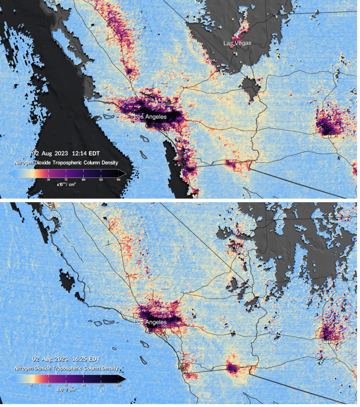
Mapping Air Pollution in the United States
NEMO and TEMPO are two scientific endeavors aimed at producing hourly air pollution maps of the United States.

Rising Sea Levels and Human Migration
Researchers predict that by 2100 between 17 to 72 million people will migrate as a result of coastal land loss due to sea level rise.

Using AI to Design Cities
Researchers now are trying to use artificial intelligence techniques, including deep reinforcement learning, to design more efficient and sustainable urban spaces.

Mapping the World’s Tidal Marshes
The first global map of tidal marsh locations was developed using satellite-based imagery.