
For the first time, the world’s tidal marshes have been mapped, providing scientists, researchers, and planers an opportunity to monitor and understand the important role they play in our ecosystems.
What are tidal marshes?
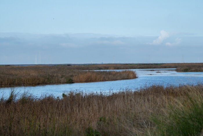
Tidal marshes are wetland ecosystems located in the intertidal zone, the area between high and low tides, along the coastline. These marshes serve as a crucial interface between terrestrial and aquatic environments. Comprising a diverse range of plant species such as grasses, sedges, and rushes, they are subjected to periodic inundation due to tidal cycles.
This fluctuation in water levels creates a unique habitat that supports a wide array of fauna, including various species of fish, crustaceans, and birds. Tidal marshes also perform essential ecological functions, such as nutrient cycling, water filtration, and carbon sequestration. Like barrier islands, tidal marshes also act as a buffer against coastal erosion and flooding, providing protection to inland areas.

Tidal marshes are extremely valuable as habitats for a variety of wildlife while protecting coastal areas from damaging floods. They also store carbon and can help in long-term goals of reducing planetary CO2 levels. Tidal marshes also act as a buffer against coastal erosion and flooding, thereby providing protection to adjacent upland areas.
Where are tidal marshes found around the world?
The new tidal map was created using 2020 Sentinel 1 and 2 data with classification techniques trained on imagery to automate tidal marsh zones, with accuracy measured at over .85 using this approach.[2]
The new map shows that approximately 45% of tidal marshes are found in North America and Northern Europe, but there are important areas in South America, East Asia, and Australia.
A map of the world’s tidal marshes will help with conservation
Now, with a new map showing key areas where tidal marshes are located, we can better track how well they are protected and potentially plan for expanding areas where they can be found.The new map was produced by the Nature Conservancy and the University of Cambridge. The map is published at 10 m resolution and is available on Google Earth Engine.[1]

The key goal of this map is to facilitate research and provide a better understanding of tidal marshes while helping with conservation. We know tidal maps are critical for various habitats, human well-being, climate, and biodiversity. Additionally, areas where tidal marshes need restoration could be identified with the new map.
There have been many mapping projects before for tidal marshes, such as the well known Chesapeake Bay area that has been studied by scientists for decades, but many regions have remained obscure. This world map allows a better overall perspective about the global importance of tidal marshes.
Over the last century, tidal marshes have been cleared, drained, and built over, resulting in less than 53,000 km2 of tidal marsh area remaining today across the world. This is less than the size of West Virginia.
Benefits of restoring tidal marshes
There is hope restoration efforts can yield beneficial results for tidal marshes. For instance, the Lightning Point restoration project in Alabama has helped to restore a degraded tidal marsh to once again attract sea birds and wildlife back to the area. Over time, this habitat can also become a beneficial blue carbon sink and helps protect the coastline from erosion and damaging hurricane surges.

There is also economic benefit as fishermen avoid damage to their ships from storms, as tidal marshes act as natural sponges during storm surges, and habitats become rich again for more sustainable forms of fishing.[3]
Lightning Point is considered a great success by the Nature Conservancy and the nonprofit would like to see it act as a blueprint to encourage other coastal communities to similarly restore tidal marsh zones. The new map can aid in this effort by identifying where the best regions to reconstitute tidal marshes would be.
Mapping the world’s mangroves help with conservation efforts
There is a similar precedent that may show there is a likely benefit to creating a global map for tidal marshes. In 2010, researchers came together to create the world’s first map of global mangroves. This has since played an important role in encouraging their conservation and enabled policymakers to make better and informed decisions in the management of mangroves.

Similar to tidal marshes, mangroves play an important role for local ecosystems and wider carbon reduction efforts. By focusing on conservation that helps benefit local communities, ecosystems, and provide overall global benefit in storing potential harmful atmospheric carbon, planners could potentially utilise the new map and see how tidal marshes can be part of countries’ national and international obligations in reducing carbon and protecting ecosystems. As the Lightning Point effort has shown, this also means benefiting communities socially and economically.[4]
It may seem that a global map of tidal marshes may not provide that much benefit outside of specialists having a tool to know where tidal marshes might be located. However, it is clear maps provide ways for many stakeholders to benefit while also being important tools for conservation and restoration efforts.
These global maps of wetland ecosystems provide a perspective that is difficult to see from a local level but they can serve as a platform to begin new conversations about ways we can better improve our efforts to protect critical ecosystems, improve our communities, and even limit some of the negative effects of increased atmospheric carbon.
References
[1] The Google Earth Engine location can be found here: https://tomworthington81.users.earthengine.app/view/global-tidal-marsh-distribution.
[2] A recent presentation on the new tidal marsh map and its benefits can be found here: https://www.nature.org/en-us/newsroom/tidal-marshes-on-the-map/. An academic presentation on the benefits can be found here: Worthington, T. A., M. Spalding, E. Landis, T. L. Maxwell, A. Navarro, L. S. Smart, and N. J. Murray. 2023. The distribution of global tidal marshes from earth observation data. bioRxiv DOI: 10.1101/2023.05.26.542433.
[3] For more on the Lightning Point restoration project in Alabama, see: https://www.nature.org/content/dam/tnc/nature/en/documents/lightningpoint.pdf.
[4] For more on the global mangrove mapping effort, see: https://www.globalmangrovewatch.org/.