

Barrier islands are narrow stretches of land that run parallel to coastlines. Made up of deposited sand and vegetation, these islands can form protective barriers that reduce coastal erosion, purify water, and help protect wildlife and vegetation.
How are barrier islands different from spits?
Barrier islands are separated from the mainland by a shallow body of water and can stretch for miles along the coast. Barrier islands are are formed from sand or sediment that accumulates offshore due to the action of tides, waves, and currents.
Spits, on the other hand, are narrow land extensions attached to the mainland at one end, extending into a body of water. If a spit is separated from the mainland by the erosion of ocean waves or by a hurricane making landfall, it can become a barrier island.
Barrier islands protect the mainland
Barrier islands get their name because they help to protect the mainland by absorbing energy from incoming waves. By creating a protected area of water, barrier islands also allow wetlands to thrive which in turn creates a supportive environment for birds and other wildlife.

Barrier Islands Also Support Recreation and Fishing Industries
Barrier islands are also home to residents and support recreation and fishing. Wildwood is a New Jersey barrier island that is a popular beach destination along the Jersey Shore. With a year-round population of 5,325, this swells to a daytime population over 250,000 during the summer months.

How many barrier islands are there in the world?
A study by researchers from Duke University in 2011 found that there are over 2,149 barrier islands worldwide, covering a total area of about 20,783 square miles (53,937 square kilometers). This study, which involved comprehensive mapping and analysis of these coastal features, found that barrier islands are more widespread than previously thought, existing on every continent except Antarctica.
It is estimated that about 10% of coastlines in the world are protected by barrier islands. Barrier islands are found on all continents except for Antarctica. Seventy-four percent of barrier islands are located in the northern hemisphere.
The United States has the most barrier islands
Of the world’s barrier islands, the United States has the most with a count of 405 barrier islands. The U.S. has extensive and diverse coastlines along both the Atlantic and Gulf coasts, where conditions are ideal for barrier island development. These coastlines have gently sloping continental shelves, which allow sand and sediment to accumulate and form islands parallel to the shore.

Where are barrier islands found in the United States?
Most of the barrier islands in the United States are found along the East Coast and Gulf Coast. Every state in this area from Maine down to Florida and over to Texas has barrier islands.
There are no barrier islands along the Pacific coast of the United States due to its rocky shoreline and short continental shelf.
Alaska’s Arctic coast also has barrier islands. The 2011 study found that 272 barrier islands, representing 12.7% of the world’s inventory, are found along coastlines that face the Arctic Ocean. These Arctic barrier islands tend to be shorter on average than barrier islands found elsewhere in the world.

Barrier islands are constantly changing
Barrier islands are susceptible to storm damage due to their sand formation, which is less stable than that of the hard bedrock characteristic of larger islands and mainland. They also tend to have very low elevations, making it easy for water to wash over and immerse the island.
Erosion from wind and waves along with severe storms are constantly altering barrier islands. Storms can flatten dunes, erode beaches, and cause the destruction and flooding of structures on the barrier islands.
When an opening on a barrier island is created by a severe storm passing through, it is known as a breach. Fire Island suffered a breach in 2012 after Hurricane Sandy hit the barrier island, splitting the island in a small wilderness area. The split has continued to widen by the impact of several nor’easters (storms that form along the East Coast).

Nor’easter storms can also dramatically impact barrier islands due to their powerful winds, heavy precipitation, and coastal flooding. These storms often cause severe erosion, where high-energy waves and storm surges strip away large amounts of sand from beaches and dunes. This erosion can lead to significant reshaping of the islands, making them narrower or even causing breaches.
Additionally, nor’easters can trigger overwash, where storm surges push water and sand over the island, flattening dunes and altering the island’s topography. This process can also damage vegetation and infrastructure, leading to long-term changes in the landscape.
In addition to physical changes, nor’easters can create new inlets or cause existing ones to migrate, potentially dividing the island or altering water flow between the ocean and bays behind the islands. These changes can disrupt the habitats of wildlife that depend on barrier islands, such as birds that nest in dunes or vegetation that stabilizes the landscape. The combined effects of erosion, overwash, and inlet formation can lead to both immediate damage and long-term ecological shifts on barrier islands.
Dauphin Island – a Barrier Island in Alabama
Dauphin Island in Alabama is the only barrier island that provides protection to much of the state’s coastal areas. Located in the Gulf of Mexico, Dauphin Island provides a protective barrier to Alabama’s coastal natural resources.

Dauphin Island is an important rest stop for migrating birds. The barrier island is the first land birds encounter when migrating north from South America.
Dauphin Island is also home to a town of the same name that has roughly 1,200 residents. The island supports recreational and commercial fishing industry as well as serving as one of the most important bird sanctuaries in the Southeast.

Assateague Island
Assateague is a 37-mile long barrier island of which two-thirds of the island is in Maryland and one-third in Virginia.

Assateague Island was made famous by Marguerite Henry’s famous book Misty of Chincoteague which gave readers a peek inside the life of the wild horses that call the island home.
The origin of how feral horses came to live on Assateague Island is steeped in folklore. Legend has it that the horses are the descendants of survivors from a shipwreck in the 1600s. The more sedate origin is that the horses were originally moved to the island by ranchers in the 17th century to avoid paying taxes.
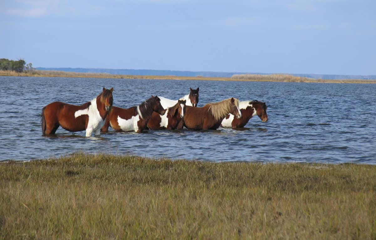
The wild horses that live on the island are found in two main herds, separated by a fence on the border between Virginia and Maryland.
On the Virginia side, the horses are managed by the Chincoteague Volunteer Fire Company which rounds them up every July to auction off the foals in order to keep the total population at 150 horses which graze on the Chincoteague National Wildlife Refuge under a permit issued by the US Fish and Wildlife Service.
On the Maryland side, the horses are managed by the National Park Service as part of the Assateague Island National Seashore and are left to live out a completely wild existence with no intervention. The federal government limits the number of wild horses via its contraceptive program which it began in 1994.

Barrier Islands in Texas
The Texas coastline boasts of at least ten barrier islands of different lengths. The better-known islands are more accessible to the mainland and include Galveston, Mustang, and Padre islands.
Galveston Island
The most significant natural habitats of Galveston Islands are its bays and wetlands, beaches and dunes, and coastal prairies. This island is also considered to be a subtropical grassland region. There are prairie areas where tallgrass grows and is home to small mammals and reptiles.
Mustang Island
According to Texas Parks and Wildlife, Mustang Island as well as its neighboring barrier islands was formed within the last five thousand years as the oceans level increased. Mustang Island as well as the other barrier islands acts as a bumper between the Gulf and the mainland.
Barrier islands serve as buffers between the open gulf and the mainland. On the gulf side, rows of sand dunes often rise thirty feet or more. The inner coast side of the dunes creates a shield from wind and salt spray, producing a sheltered environment for vegetation and wildlife. This is important since the coastal grasses native to this environment maintain dune integrity. The grasses provide protection to the dunes, meadows, and other natural characteristics of the islands.
Padre Island
According to the Texas Bureau of Economic Geology, Padre Island was formed during the Holocene era, when the glaciers melted and the sea level rose to reach a point close to what it is today. During that time valleys were flooded forming existing bays and estuaries all along the Texas coastline.
Several systems are implicated in the formation of Padre Island and neighboring barrier islands: the wind and ocean. Sand and depositions transported during storms continue to form Padre Island’s geology. The Texas Bureau of Economic Geology also has recorded Padre Island’s maximum sediment thickness to be approximately 35 to 40 feet, depending on dune formations.
In addition to sand dunes formation, different sectors of Padre Island have undergone a stability phase, and possibly are now in the process of erosion. As noted in the Texas Bureau of Economic Geology, a great section of the northern part of the island is in the stability phase, the rest of the island may already be in the erosion phase. The Texas Bureau of Economic Geology also predicts that due to the decrease in sediment buildup, the rise of sea level, and tropical storms the island will retreat landward.

World’s Longest Stretch of Undeveloped Barrier Island
The United States is also home to the world’s longest stretch of undeveloped barrier island with a length of 13 mi (182 km). The largest barrier island in Texas, Padre Island is located off the coast of South Texas and is part of the Padre Island National Seashore, a national park.
Padre Island has developments on either end of the barrier island with the town of South Padre Island on its southern end and the city of Corpus Christi at the northern end.
The barrier island separates the Gulf of Mexico from 70 miles of coastline of the South Texas coastline. In between lies Laguna Madre, one of the few hypersaline lagoons in the world.
Padre Island serves as a sanctuary for over 380 bird species and is a nesting ground for Kemp’s ridley sea turtle, the rarest species of sea turtle and the world’s most endangered species of sea turtles. Kemp’s ridley sea turtle are also the smallest marine turtles in the world.
World’s Longest Chain of Barrier Islands
The 2011 study also found that the world’s longest chain of barrier islands is a 54-island chain that “extends 571 kilometers along the fringe of a mangrove forest south of the mouth of the Amazon River” along the coast of Brazil.
This article was originally written on January 9, 2021 and has since been updated.
References
Alabama barrier island restoration assessment at Dauphin island. (n.d.). USGS.gov | Science for a changing world. https://www.usgs.gov/centers/wetland-and-aquatic-research-center-warc/science/alabama-barrier-island-restoration
Schreppel, H. (n.d.). Barrier islands. USGS. https://wim.usgs.gov/geonarrative/cch-bi/
Stutz, M. L., & Pilkey, O. H. (2011). Open-ocean barrier islands: global influence of climatic, oceanographic, and depositional settings. Journal of Coastal Research, 27(2), 207-222. https://doi.org/10.2112/09-1190.1
Texas Bureau of Economic Geology: Padre Island National Seashore: A guide to the geology, natural environments, a history of a Texas barrier island. https://www.nps.gov/parkhistory/online_books/pais/1980-17/index.htm