
Geomorphology

Geography Facts about the World’s Continents
How many continents are there? Explore the four to seven continent models and compare the world's continents by size, population, and geography.

Highest Point in Every U.S. State
Every U.S. state's highest point, from Denali to Britton Hill, with elevations, maps, and geographic facts.

Barrier Islands in the United States
Barrier islands are narrow landforms running parallel to coastlines, protecting shores from storms and erosion while supporting unique ecosystems.

The World’s Smallest Mountain Range
Surrounded by flat farmland, the Sutter Buttes are an isolated volcanic landform often described as the world's smallest mountain range.

Geography of Atolls
Atolls are ring-shaped coral reefs, islands, or a series of islets that encircle a lagoon either partially or completely.

What is England’s Highest Mountain?
Found at 978 metres (3,209 ft) above sea level, Scafell Pike is located in Lake District National Park in Cumbria.

The Highest 11 Mountains in the United States
Learn about the highest 11 mountains in the United States.

U.S. States With the Most Extreme Elevation Spans
Here are the states with the greatest difference in elevation between the highest and lowest points.

Tallest Active Volcano in Eurasia
With an elevation of 15,597 feet (4,754 meters) Klyuchevskoy is Eurasia's tallest active volcano.

Largest Dome Volcano in the World
Lassen Peak is the world's largest dome volcano with a height of 10,457 feet (3,187 meters).

A Harbor in the Center of a Volcano
Deception Island is one of the only places in the world where ships can sail directly into the middle of an active volcano.

Where is the World’s Largest Salt Flat?
Salar de Uyuni in Bolivia, is the largest salt flat in the world and one of the world's largest reservoirs of lithium.

When Did the Anthropocene Begin?
The Anthropocene is a proposed geological epoch defined by the significant influence of human activity on Earth's ecosystems and geology.

Five Basic Types of Sand Dunes
Sand dunes are mounds, hills, or ridges of sand built by wind. Learn about the five basic types of sand dunes.

Why are Most Meteorites Found in Antarctica?
More meteorites have been found in Antarctica than all other continents combined. Why is that?
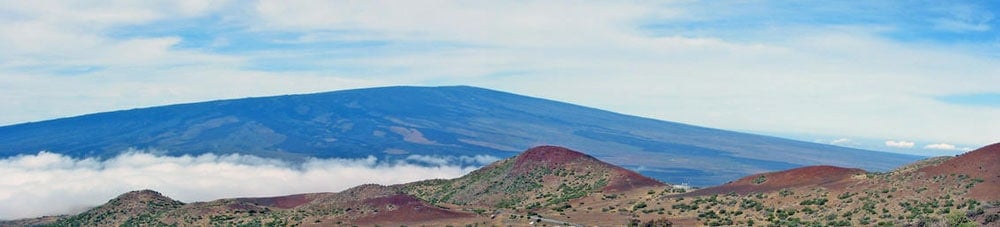
Geography Facts About the World’s Largest Active Volcano
Hawaii's Mauna Loa is the world's largest subaerial volcano as well as the world's largest active volcano.

Geography of Kansas
Flat expanses, badlands, rolling hills, cuestas, and canyons shape Kansas' geography.

Mapping Caves
Mapping caves has proved difficult, especially vast, complicated caves that can span for kilometers underground.

Visual Geography: the Shape of Land Near the Oceans
A visual dictionary of geography words that describe the shapes of land near ocean water.

Geography of Saharan Dust: Where and How Does it Travel?
The Saharan Desert produces vast amounts of atmospheric dust, which is carried and deposited thousands of kilometers away by strong winds traveling over great distances.

The First Newly Formed Island to Survive in the Satellite Era
The first newly formed island to survive in the age of remote sensing is Hunga Tonga-Hunga Ha'apai.

Geography of Igneous Rocks in the United States
About 15% of the Earth's present land surface is made up of igneous rocks.

Geography Facts about Kīlauea
Kīlauea is the youngest and most southeastern volcano on Hawaii island.

Sand Dunes in the United States
Discover the diverse sand dunes across the U.S., from towering Great Sand Dunes in Colorado to coastal dunes along the Atlantic and Pacific shores.


Pacific Ring of Fire
The Ring of Fire refers to the long chain of volcanoes and earthquake zones that encircle much of the Pacific Ocean.