
Located on the island of Hawaii, Mauna Loa is the world’s largest subaerial volcano in both mass and volume and the world’s largest active volcano.
Mauna Loa November 2022 eruption
Starting around 11:30 p.m. HST on November 27, 2022, Mauna Loa began erupting after a quiescence of 38 years. Prior to the most recent volcanic activity, Mauna Loa last erupted in 1984.
While the eruption was initially restricted to the summit, volcanic activity has now moved to Mauna Loa’s Northeast Rift Zone. A number of lava flows are being fed by fissures in the Northeast Rift Zone. These lava flows have the potential to travel in north, west, northwest, south, and southwest directions.
Lava flows, ash and tephra (the rocks and other debris ejected during a volcanic eruption) fall, and heavy vog (volcanic smog) are among the natural hazards and Mauna Loa has been closed to visitors.
Live webcams showing the summit of Mauna Loa can be viewed from the USGS website.

Learn some geography facts about Mauna Loa.
Volcanos on the Island of Hawaii
Along with Kīlauea, Mauna Loa is one of two active volcanoes located within Hawaii Volcanoes National Park on the island of Hawaii, also known as the Big Island. There are three other volcanoes on the Big Island outside of the National Park boundary: Mauna Kea, Hualālai, and Kohala.
These volcanos were formed as the Pacific tectonic plate migrated over the Hawaii hotspot in the Earth’s underlying mantle. Related: The United States Ranks Third for Historically Active Volcanoes
Map of Mauna Loa
Mauna Loa and the other four volcanoes that make up the island of Hawai‘i are seen on a map of the island of Hawai‘i. The map also shows the summit caldera, rift zones, radial vents, and historical lava flows that are all structural aspects of Mauna Loa.

Mauna Loa is a Shield Volcano
Mauna Loa is Hawaiian for “long mountain”. Mauna Loa is a shield volcano which means it’s wider that it is tall. Mauna Loa has a large, gently sloping dome-like structure that is made nearly completely of lava flows that emerge from central vents.
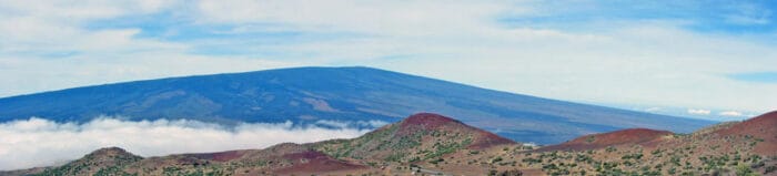
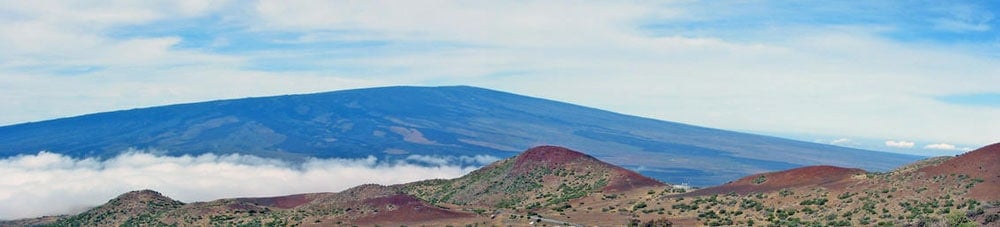
Mauna Loa’s gradual slope, can been seen from the north sides of Mauna Kea in the photo below. On the volcano’s slope, younger lava flows are dark. Clouds can be seen in the eastern saddle between the two volcanoes.
How Big is Mauna Loa?
Mauna Loa holds the title as the world’s largest active volcano.
Mauna Loa has an elevation of 13,679 feet (4,169 meters) above sea level with an additional depth of 16,400 feet (5,000 meters) below sea level. Much of Mauna Loa is submerged beneath the surface of the Pacific Ocean. The weight of Mauna Loa further depresses the seafloor 26,250 feet (8,000 meters).
The total height of Mauna Loa from base to summit is nearly 56,000 feet (17,000 meters). (All measurements from USGS.gov).

The volcano is taller from base to summit than Mount Everest (Chomolungma in Tibetan) which is 29,029 feet (8,848 meters) above sea level.
Mauna Loa makes up around 51% of the Big Island’s landmass, and its weight is so great that it physically depresses the ocean floor beneath it.
Mauna Loa Volcanic Activity

About half of the eruptions begin at the summit and migrate into either the Northeast or Southwest Rift Zone over a time span ranging from minutes to months of the start of an eruption.

How many times has Mauna Loa erupted since 1843?
The volcano has erupted 34 times since 1843, which is when written records of Mauna Loa’s eruptions started. The intervals range from months to decades between eruptions. This averages out to an eruption roughly every five years for Mauna Loa since 1843.
Prior to the most recent volcanic activity that started on November 27, 2022, Mauna Loa last erupted from March 24 to April 15, 1984. The eruption followed a series of earthquakes that began in September of 1983. The 38-period of quiet between the 1984 and 2022 eruption was the longest stretch of non-eruption in recorded history of Mauna Loa.
Since 1843, there has been no explosive eruption from Mauna Loa although there is evidence of explosive activity in the last 1,000 to 300 years based on geologic records.

Caldera
Mauna Loa’s large summit caldera is Moku‘āweoweo which measures 6 by 2.5 km (2.8 by 1.6 mi). Most eruptions flow from this caldera before migrating to one of two rift zones to the northeast and southwest.

Snow on Mauna Loa
Almost every year, Mauna Kea and Mauna Loa (elevations exceeding 13,600 feet/4200 meters) get a sprinkling of snow that lasts a few days. Related: Snow in Hawaii
This Landsat 8 image from February 6, 2021 shows both Mauna Kea and Mauna Loa covered in snow.

Hawaiian petrel
The Hawaiian petrel (Pterodroma sandwichensis), or ‘ua’u, is a is a federally endangered native seabird that nests at high elevations on the on the lower alpine and subalpine slopes of Mauna Loa. Only 50 to 60 breeding pairs are left, according to wildlife specialists.

References
Geology of Hawai’i volcanoes National Park. (n.d.). USGS.gov. https://www.usgs.gov/science-support/osqi/yes/national-parks/geology-hawaii-volcanoes-national-park
Mauna Loa. (n.d.). NPS.gov (U.S. National Park Service). https://www.nps.gov/havo/learn/nature/mauna-loa.htm
Mauna Loa: Geology and history. (2016, March 24). USGS.gov. https://www.usgs.gov/volcanoes/mauna-loa/geology-and-history
Kauahikaua, J. P., & Mulliken, K. M. (2020, June 4). Simplified table of Mauna Loa historical activity modified from Lockwood and Lipman (1987). USGS. https://www.usgs.gov/media/files/simplified-table-mauna-loa-historical-activity
‘Ua‘u – Hawaiian petrel. (2021, February 18). NPS.gov (U.S. National Park Service). https://www.nps.gov/havo/learn/nature/uau.htm