
Kīlauea is the youngest and most southeastern volcano on Hawaii island, the largest island in the archipelago of eight major islands, atolls, seamounts, and islets that form the state of Hawaii.
Kīlauea is one of five volcanos that form the Big Island of Hawaii. All five volcanoes are shield volcanoes which have a low profile.
The other four volcanos are:
- Kohala – extinct
- Mauna Kea – dormant
- Hualālai – dormant
- Mauna Loa – active, partly within Hawaiʻi Volcanoes National Park
The summit of Kīlauea is 4,091 feet (1,247 meter)
Kīlauea is the most active of the volcanoes on the island of Hawaii
The most active of the five volcanoes on the island of Hawaii is Kīlauea. In the Hawaiian language, the name means “spewing” or “much spreading” .

Magma
Kīlauea is located along the southeastern flank of the nearby volcano Mauna Loa, the world’s largest active volcano. Kīlauea was originally believed to be a satellite of Mauna Loa. However, Klauea has its own magma-plumbing system that extends to the surface from more than 60 km below the earth’s surface.

Eruptions
Kīlauea has erupted 35 times since 1952.
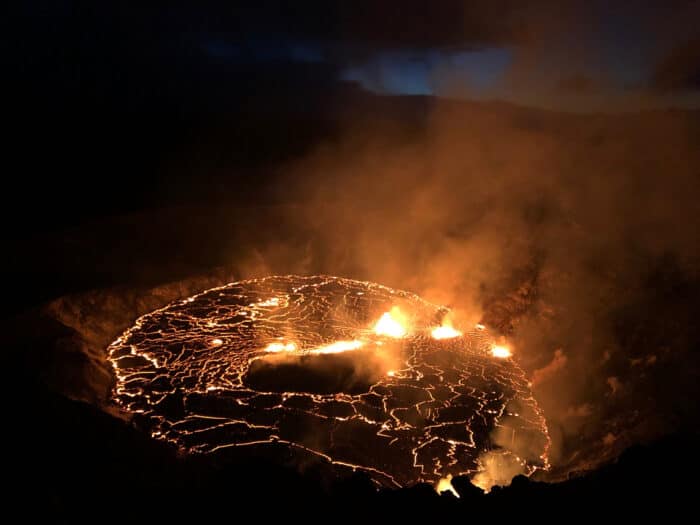
The most current eruption is ongoing as of September 30, 2021. The USGS Hawaiian Volcano Observatory (HVO) detected glow in Klauea summit webcam images at approximately 3:20 p.m. HST on September 29, 2021, indicating that an eruption had begun within Halemaumau crater in Klauea’s summit caldera.

From December 2020 to May 2021, a summit eruption created a lava lake within Halema‘uma‘u crater.
Related