
United States
Articles and information related to the geography of the United States

Hydroclimate Whiplash: the Impact on California Wildfires
Rapid shifts between extremely dry and unusually wet conditions are reshaping California’s fire landscape by increasing vegetation growth, drying fuels, and contributing to more intense wildfires.

Barrier Islands in the United States
Barrier islands are narrow landforms running parallel to coastlines, protecting shores from storms and erosion while supporting unique ecosystems.

How Many States Are Along the East Coast and West Coast of the United States?
Learn how many states are along the East Coast and how many states are along the West Coast.

Geography of Giant Sequoias
Giant sequoias are one of the longest lived tree species, with the oldest giant sequoia living an estimated 3,400 years.

Which States Have the Highest Percentage of Water Area?
Water shapes U.S. states' geography and ecosystems. Which states have the highest and lowest percentages of area covered by perennial water?

These Two Countries are Separated by 2.4 Miles and 21 Hours
There exists a geographic point where two of the largest countries in the world are only separated by a 2.4 miles but are 21 hours apart.

Geography of Lightning Strikes in the United States
Researchers recently mapped out data from the U.S. National Lightning Detection Network (NLDN) between 2017 and 2022 to see where lightning strikes the most across the contiguous United States.

What is the Outlook for California’s Atmospheric Rivers?
During the winter months, atmospheric rivers carry enormous amounts of water to the state of California.


Exploring Rainbows and Moonbows
Rainbows and moonbows occur when light is refracted through drops of water in the sky.


The Highest 11 Mountains in the United States
Learn about the highest 11 mountains in the United States.

U.S. States With the Most Extreme Elevation Spans
Here are the states with the greatest difference in elevation between the highest and lowest points.

Study: Human Activities Have Changed How Wolves Hunt Deer
Logging, linear features, and human infrastructure are changing where wolves hunt for deer.

Largest Dome Volcano in the World
Lassen Peak is the world's largest dome volcano with a height of 10,457 feet (3,187 meters).

Timing Mismatch is Resulting in Fewer Birds
A study has found that shifts in the timing of spring seasons, linked to climate change, are impacting bird breeding patterns and leading to less offspring.

2023 Wildfires in the Western United States
So far in early August of 2023, the wildfire season in the western United States has not been as intense as prior years when a years-long drought was raging.

Florida’s Burmese Python Invasion
The introduction of the Burmese Python into Florida has resulted in the decline of many native mammals in the Florida Everglades.

Chaparral in California
Chaparral ecosystems in California are characterized by dense shrubs and rocky terrains and span from maritime zones to mountain slopes.

Geography of Vultures in the United States
The United States is home to three species of vultures: turkey vulture, black vulture, and the California condor.

California’s Wet Winter Brought Back an Ancient Lake
The once-vanished Tulare Lake reemerged after an exceptionally wet California winter, reclaiming a portion of its historic expanse in 2023.

A to Z Geography: United States
The geography of the United States is diverse, featuring rugged mountains, arid deserts, dense forests, and expansive coastlines.

Geography of Superblooms in the United States
California's wet winter rains help drive the simultaneous blooming of a large number of wildflowers in the state's desert regions.

A to Z Geography: Wisconsin
Wisconsin's geography is dominated by its location in the Great Lakes region, which has created a diverse landscape of fertile farmland, dense forests, and numerous lakes and rivers.

A to Z Geography: Wyoming
Wyoming, the 10th largest state in the United States, is a landlocked state located in the western part of the ...
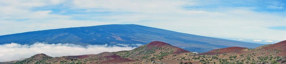
Geography Facts About the World’s Largest Active Volcano
Hawaii's Mauna Loa is the world's largest subaerial volcano as well as the world's largest active volcano.