
The topography of the United States is very diverse. The high points in the country range from Denali, the tallest mountain in the United States located in Alaska with an elevation of 20,310 feet, to states with high points that barely rise above the surrounding areas. The state with the lowest high point is Britton Hill in Florida with a rise of just 345 feet.
Discover the highest point in each U.S. state. Eight of the state high points are found in National Parks.
How high and low are the highest points in the United States?
Only one state, Alaska, has a highest elevation over 20,000 feet with Denali. This is also the highest point in North America.

All of the states with highest elevations above 10,000 feet are found in the western region. There are 13 states in total with elevations that rise above 10,000 feet: Alaska, Hawaii, Washington, Oregon, California, Montana, Idaho, Utah, Nevada, Arizona, Wyoming, Colorado, and New Mexico.
At the other extreme, six states have no point that rises above 1,000 feet: Florida, District of Columbia, Rhode Island, Mississippi, Delaware, Louisiana.
Map of the highest point in each U.S. state
This map shows the highest point with labels for each state in the United States as well as the District of Columbia.

Alabama

Bunker Tower, also known as Bunker Hill Tower or the Cheaha Observation Tower, is built at the highest natural elevation in Alabama within Cheaha State Park on Cheaha Mountain in Alabama. The tower is made predominantly of locally sourced sandstone and wood designed to blend seamlessly with the surrounding environment. The building features a tower that leads up a flight of stairs to a covered observation deck with a telescope for observing.

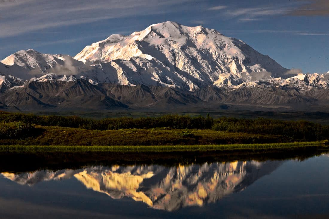
Alaska
Denali is part of the Alaska Range which stretches 600 miles along the Alaska-Canada border.
Arizona

Arkansas

California

The Advanced Spaceborne Thermal Emission and Reflection Radiometer (ASTER) instrument on NASA’s Terra probe created this 3-D perspective image of Mount Whitney. The western view shows the Alabama Hills in the foreground, a favored locale featured in hundreds of Western movies.

Colorado

Connecticut

Delaware

District of Columbia

Florida

Georgia

Brasstown Bald is notable not only for being the highest natural elevation in Georgia but also for the panoramic views it offers of the surrounding landscape, including parts the states of North Carolina, South Carolina, and Tennessee on clear days.
Hawaii
Mauna Kea is the highest point in Hawaii and the world’s second-highest peak on an island after Puncak Jaya on the island of New Guinea.
A dormant volcano, Mauna Kea is about one million years old.
Mauna Kea is the fourth oldest of the five volcanoes that form the island of Hawaii. (Related: Geography Facts About the World’s Largest Active Volcano – Mauna Loa)

Idaho
Mount Borah is not only the highest point in Idaho, it is also the state’s only active glacier. A 6.9 magnitude earthquake on October 28, 1983, the largest historical earthquake in Idaho, resulted in the mountain rising one foot (30 centimeters).
The previous measures of Mount Borah were based on maps, compasses and altimeters according to Tom Carlson, the Washington, Oregon, Idaho, and Montana National Map liaison for the U.S. Geological Survey. Updated LiDAR measurements collected as part of the USGS’ 3D Elevation Program indicate that Mount Borah is actually 12,666 feet, which is four feet higher than current official records.

“There are many geologists who are very wise, but even they do not understand the forces which produce mountains. And yet it must be admitted, not only that mountains have been made, but that some mountains are still rising” ~ Geologist G. K. Gilbert, 1883
Illinois
The highest natural point in Illinois is located on private property. Located on the farmland belonging to Jean and Wayne Wuebbels, public access is limited to daylight hours on the first full weekends of the months of June, July, August, and September.
Charles Mound is located in the Driftless Area, which stretches over Illinois, Iowa, Minnesota, and Wisconsin. Driftless Area gets its name from the fact that the region was not covered or crushed down by the last continental glaciers.
Indiana
Iowa
Hawkeye Point: 1,670 feet (509 meters)
Located in Osceola County, Hawkeye Point is the highest point in Iowa. A mosaicked compass rose with a star marking the location on a map of Iowa marks this high point. The land where the Hawkeye Point is located was donated to the local government by the Sterler family who had farmed it for decades.
Kansas
Mount Sunflower: 4,039 feet (1,232 meters)
While the highest point in Kansas is called Mount Sunflower and it is the state’s highest natural peak in terms of elevation, it is nearly indistinguishable from the surrounding High Plains terrain. Elevation in Kansas gradually increases from east to west.
The high point is on private land but visitors are allowed with a picnic area and a sunflower sculpture garden made from railroad spikes.
Kentucky
Black Mountain: 4,145 feet (1,264 meters)
Also known as Katahrin’s Mountain, Black Mountain is the highest point in Kentucky by more than 500 feet.
The area around Black Mountain has long been a mining area with the mountain under private ownership. In 1999, the Commonwealth of Kentucky reached an agreement with local coal operators that created the Timber Purchase Area and the Timber Conservation Easement Area which eliminated surface mining at the summit and created a 18,000+ acre buffer zone below the summit.
Black Mountain is a important region for the growth of Northern Hardwoods forests and supports animals like Wehrle’s salamander and the Indiana bat (Myotis sodalis).
Louisiana
Driskill Mountain: 535 feet (163 meters)
Also known as Mount Driskill, Driskill Mountain is the highest point in Louisiana. Driskill Mountain was created by unlithified Paleogene sediment being eroded.
Maine
Mount Katahdin: 5,268 feet (1,607 meters)
Maine’s highest point was named by the Penobscot Native Americans. Located in Baxter State Park, Katahdin means “The Greatest Mountain”. The National Park Service designated Mount Katahdin as a National Natural Landmark in 1967.
The Appalachian Trail’s northern endpoint is Mount Katahdin.

Maryland
Hoye-Crest 3,360 feet (1,025 meters)
The highest point in Maryland is a summit along Backbone Mountain called Hoye-Crest. Located on private property, access to Hoye-Crest is actually reached through a foot trail that starts in Virginia from a point along U.S. Route 219 just south of Silver Lake, West Virginia.

Massachusetts
Mount Greylock: 3,491 feet (1,065 meters)
Massachusett’s highest point is Mount Greylock located in the northwest corner of the state. Visitors to the summit can see as far away as 90 miles on a clear day.
With the donation of 400 acres of property in 1898, Mount Greylock became Massachusetts’ first state reservation. The reservation now spans over 12,500 acres and includes an 11.5-mile stretch of the Appalachian Trail.
The only old-growth red spruce stands known to exist in southern New England are found on the steep northwest slopes of Mt. Greylock, Massachusetts’ highest mountain.

Michigan
Mount Arvon 1,979 feet (604 meters)
Part of the Huron Mountains, Mount Arvon is Michigan’s highest point. While Mount Arvon is owned by Weyerhaeuser, public access is allowed. Located in Michigan’s Upper Peninsula in Baraga County, a USGS benchmark marks the location of the summit.
Minnesota
Eagle Mountain 2,301 feet (702 meters)
Made of granite, Minnesota’s highest point is part of a large rock formation called the Duluth Complex. Located in northern Cook County, Eagle Mountain is part of the Misquah Hills and lies within the Boundary Waters Canoe Area Wilderness (BWCAW) in the Superior National Forest.
Eagle Mountain is only about 15 miles (24 kilometers) away from Lake Superior, which holds the title of Minnesota’s lowest elevation point at 600 feet (183 meters).
Mississippi
Woodall Mountain: 806 feet (246 meters)
Mississippi’s highest point is located in the northeast part of the state in Tishomingo County.
Also known as Yow Mountain or Yow Hill, Woodall Mountain also is referred to as America’s Bloodiest High Point. In 1862 the Battle of Iuka was fought here during the Civil War.
The mountain was renamed in 1878 after Zephaniah Woodall, Sheriff of Tishomingo County.
Missouri
Taum Sauk Mountain: 1,772 feet (540 meters)
Located in the Saint Francois Mountains, Taum Sauk Mountain is the highest point in Missouri. The mountain was named after a Piankeshaw chief named Sauk-Ton-Qua.
A 7,448-acre (30.14 square kilometers) state park around Taum Sauk Mountain was created in 1991.

Montana
Granite Peak 12,807 feet (3,904 meters)
Granite Peak is the highest point in Montana and the tenth highest point for a state. Granite Peak is located in the Beartooth Mountains, which are part of the larger Rocky Mountains range, near the northern end of Yellowstone National Park.The Beartooth Mountains are known for their rugged terrain and striking high-altitude landscapes, which were shaped by extensive glacial activity during the last Ice Age.
Considered a challenging mountain to climb, considered by some to be second in nature after Denali, the first recorded ascent of Granite Peak was made by Elers Koch, James C. Whitham, and R.T. Ferguson on August 29, 1923.

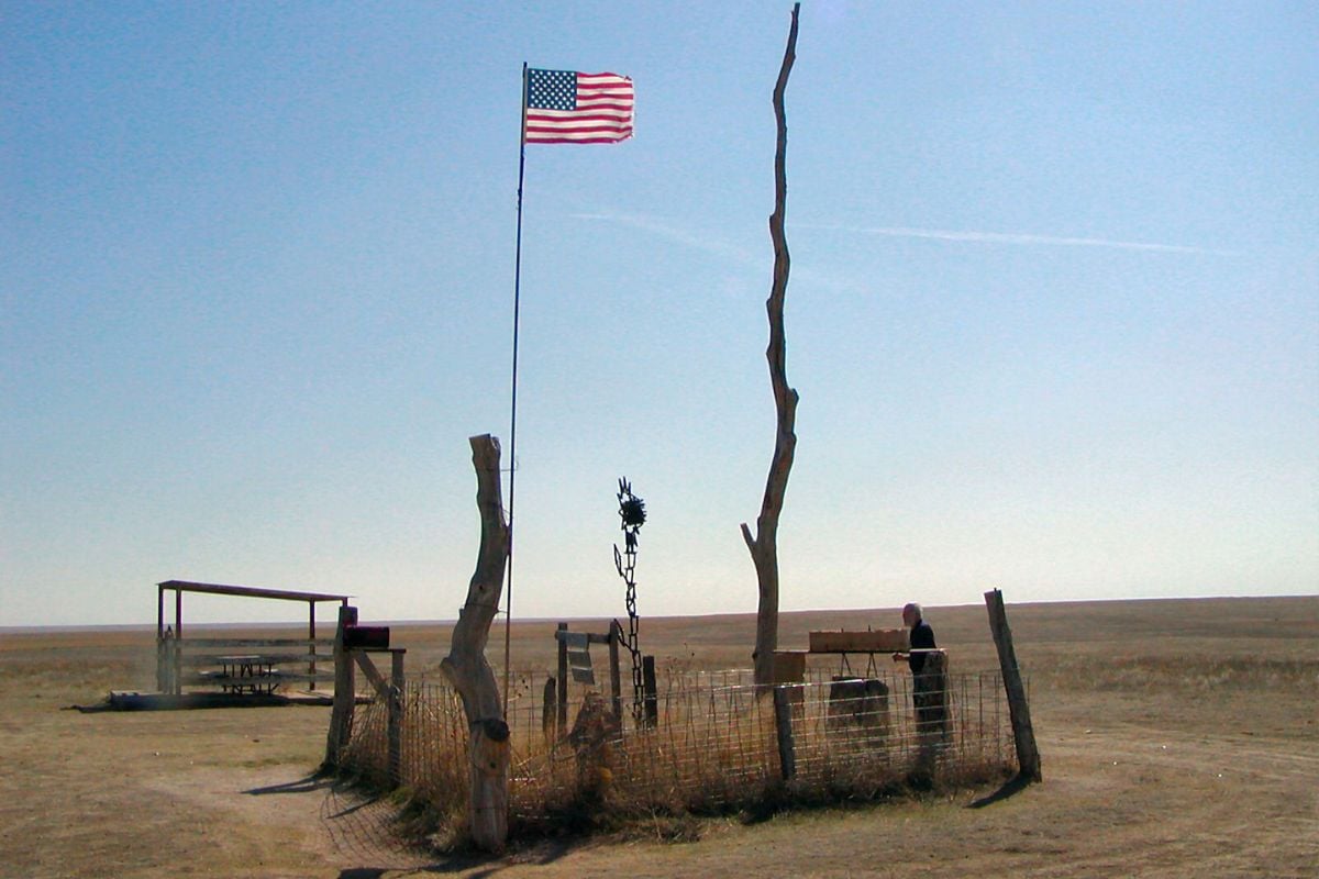
Nebraska
Panorama Point: 5,429 feet (1,655 meters)
The highest point in Nebraska is Panorama Point. Panorama Point is a low rise on the High Plains. Panorama Point is located in Kimball County, near the state’s western border. The high point is marked by a registry and a stone marker.
Unlike many state highpoints that are mountain peaks or rugged hills, Panorama Point is notable for being located on a relatively flat plateau. The landscape is characteristic of the High Plains region, featuring expansive views of the surrounding grasslands. This area is part of the larger Great Plains, which stretch across much of the central United States.
One of the distinctive geographies of Panorama Point is its proximity to the borders of Colorado and Wyoming; it’s just a few miles from each state line.
Access to Panorama Point is on private land, High Point Bison Ranch. However, the owners allow public access for a small fee. The approach to the highpoint is via a dirt road, and a marker and a guest register are located at the site for visitors to record their visit.

Nevada
Boundary Peak 13,140 feet (4,007 meters)
Located in Boundary Peak Wilderness, Boundary Peak is the highest point in Nevada and the ninth highest state point. Boundary Peak derives its name from its close proximity to the border between Nevada and California, only half a mile away. It’s worth noting that while Boundary Peak is the highest point in Nevada, it is not the highest peak in the White Mountains; that distinction belongs to White Mountain Peak in California, which is just a few miles away and taller.
The summit provides views of Mono Lake basin to the north, the Sierra Nevada Mountains to the west, the White Mountains Wilderness to the south, while Nevada’s Basin and Range extends to the east. Boundary Peak is located in the Humboldt-Toiyabe National Forest.

New Hampshire
Mount Washington: 6,288 feet (1,918 meters)
Mount Washington, known as Agiocochook by some Native American tribes, is the highest point in New Hampshire.
On April 12, 1934, Mount Washington experienced the highest ever wind speed recorded for on the surface of the Earth at 231 miles per hour. This record held until 1996. During Tropical Cyclone Olivia, Barrow Island, Australia set a new speed record of 253 miles per hour.

New Jersey
High Point: 1,803 feet (550 meters)
The highest point in New Jersey is High Point, the summit of the Kittatinny Ridge. Kittatinny Ridge is the result of continental collisions crumpling the earth’s crust, mile-high ice sheets grinding the earth’s crust, and centuries of erosion washing soil and rock into valleys.
Located in High Point State Park, New Jersey’s highest point is marked by the High Point Monument, a 220-foot (67-meter) obelisk that was erected as a war memorial in 1930.

New Mexico
Wheeler Peak: 13,161 feet (4,014 meters)
Wheeler Peak is the highest point in New Mexico. Wheeler Peak is located in the Sangre de Cristo Mountains, which are the Rocky Mountains’ southernmost subrange.
A plaque is located at Wheeler Peak:
Named in honor of Major George Montague Wheeler (1832–1909) who for ten years led a party of surveyors and naturalists collecting geologic, biologic, planimetric and topographic data in New Mexico and six other southwestern states.
Wheeler Peak Wilderness encompasses almost 20,000 acres of rugged terrain.
Because of its elevation, Wheeler Peak is one of the few spots in New Mexico where you may view a true alpine “mat” rather than the grasses that grow in other high alpine areas. The “mat” produces stunning flowers in a rainbow of colors.

New York
Mount Marcy: 5,344 feet (1,630 meters)
Mount Marcy is named after 19th century governor William L. Marcy who had an environmental survey done of the area. Mount Marcy is known as Tewawe’éstha (“it pierces”) in Mohawk and Tahawus (“cloud-splitter”) in Algonquin.

North Carolina
Mount Mitchell: 6,684 feet (2,039 meters)
Mount Mitchell is the highest mountain in mainland eastern North America and the highest point in the Appalachian Mountains. The highest point in North Carolina, Mount Mitchell was called Attakulla by the Cherokee. Mount Mitchell is part of the Black Mountain range, a subrange of the Appalachian Mountains, and is situated within the Pisgah National Forest.
Elisha Mitchell, a science professor and geologist at the University of North Carolina, was the first to measure the peak in 1835. In 1915, Mount Mitchell became North Carolina’s first state park.

North Dakota
White Butte: 3,506 feet (1,069 meters)
The highest point in North Dakota, White Butte is a prominent butte in Slope County, in the Badlands of the southwestern part of the state. Situated in Slope County, near the town of Amidon, White Butte is part of the Little Missouri National Grassland.
White Butte is located on private property owned by the Dennis family, who live close by. They have set up a donation receptacle near the parking area, one mile north of the trailhead, to fund the maintenance of the area. A $5 contribution is requested from visitors for this fund.
Ohio
Campbell Hill: 1,549 feet (472 meters)
The highest point in Ohio, Campbell Hill is 2 miles (3.2 km) northeast of downtown Bellefontaine in the city of Bellefontaine. Campbell Hill is a glacial moraine. Historically, Campbell Hill was part of the Bellefontaine Outlier, a group of hills that are remnants of an ancient, eroded mountain range.
Campbell Hill is located on the property of the Ohio Hi-Point Career Center, a vocational school, and was previously part of a U.S. Air Force radar station during the Cold War era. An Ohio Historical Marker marks the spot of the highest point in the state.
Oklahoma
Black Mesa: 4,973 feet (1,517 meters)
Black Mesa, located in northwest Cimarron County, Oklahoma, is the highest point in Oklahoma at 4,973 feet. Black Mesa is a mesa that spans the U.S. states of Colorado, New Mexico, and Oklahoma.
The name Black Mesa comes from a layer of black lava rock that covered the mesa around 30 million years ago. At Black Mesa, the Rocky Mountains meet the shortgrass prairie, creating a unique environment where many species are at the eastern or western limits of their range.
Oregon
Mount Hood: 11,249 feet (3,429 meters)
The highest point in Oregon, Mount Hood is a stratovolcano in the Cascade Volcanic Arc that is potentially active. The last eruption was in 1781 and Mount Hood has been quiet since the mid 1800s.
Mount Hood experienced a magnitude 3.9 earthquake on June 5, 2021. The earthquake occurred at a depth of 2.7 miles below sea level and was not considered by experts to signal a change in volcanic hazard at Mount Hood.
Mount Hood, provides a striking backdrop to Portland, the state’s largest metropolis.

Mount Hood has been assigned different measurements over the last 150 years: 11,249 feet (3,429 m), a 1991 adjustment of a 1986 measurement by the U.S. National Geodetic Survey (NGS), 11,240 feet (3,426 m) from a 1993 scientific expedition, and 11,239 feet (3,425.6 m) from a previous USGS measurement.
Pennsylvania
Mount Davis: 3,213 feet (980 meters)
Pennsylvania’s highest point is located in Forbes State Forest. Mount Davis was named after John Nelson Davis, an early resident, American Civil War veteran, surveyor, and naturalist notable for his study of the mountain’s flora and fauna.
Rhode Island
Jerimoth Hill: 811 feet (247 meters)
Jermimoth Hill is Rhode Island’s highest point. The location is marked with a federal geodetic survey marker.
Until 2005, Jerimoth Hill was challenging to visit due to a former landowner prohibiting visitors. The land is now owned by the State of Rhode Island.
Jerimoth Hill is reached by walking along a .3-mile (480 m) long path off Hartford Pike.
South Carolina
Sassafras Mountain: 3,554 feet (1,083 meters)
Located in the Blue Ridge Mountains, Sassafras Mountain is South Carolina’s highest point.
In 2019, an observation tower known as Sassafras Mountain Tower was opened on top of Sassafras Mountain. The tower is positioned 11 feet above the mountain’s highest point.
South Dakota
Black Elk Peak: 7,244 feet (2,208 meters)
Black Elk Peak is the highest point in South Dakota. The peak was renamed from Harney Peak on August 11, 2016 by the U.S. Board on Geographic Names to honor Black Elk, a Lakota Sioux medicine man.

Published elevation measurements of the peak have varied between 7,240 and 7,244 over the years since surveyors measured the height of Black Elk Peak in the late 1890s . In 2016, professional surveyors calculated the highest point to be 7,231.32 feet (2,204.11 meters) on the North American Vertical Datum of 1988 (NAVD88). That measurement has not been adopted by authorities.
Tennessee
Clingmans Dome: 6,643 feet (2,025 meters)
Clingmans Dome is the highest point in Tennessee and the third tallest mountain east of the Mississippi River, standing at 6,643 feet (2,025 meters). Clingsman Dome is located in the Great Smoky Mountains National Park, which straddles the border between Tennessee and North Carolina.
One of the most distinctive features of Clingmans Dome is the observation tower at the summit. This concrete structure, built in 1959, offers 360-degree panoramic views of the surrounding mountains and valleys. On clear days, visibility can extend for over 100 miles, and the vistas include several other major peaks in the Great Smoky Mountains.
The climb to the summit of Clingmans Dome is accessible via a paved, but steep, half-mile walkway. Due to the high elevation, the walk can be more challenging than it initially appears. The area around Clingmans Dome is characterized by a spruce-fir forest.

Texas
Guadalupe Peak: 8,751 feet (2,667 meters)
Guadalupe Peak, known as the “Top of Texas,” is the highest natural point in the state, with an elevation of 8,751 feet (2,667 meters). It is located in Guadalupe Mountains National Park in West Texas, near the New Mexico border. This peak is part of the Guadalupe Mountains, an ancient limestone reef that dates back to the Permian period. that was once part of a vast inland sea that existed between 251 and 299 million years ago.
A stainless steel pyramid stands at the summit of Guadalupe Peak, erected in 1958 by American Airlines. This monument commemorates the centennial of the Butterfield Overland Mail, a historic stagecoach route near the mountain. The pyramid features three distinct sides: one with the American Airlines logo, another honoring the Pony Express Riders of the Butterfield Stage with a U.S. Postal Service tribute, and a third side showcasing a compass along with the Boy Scouts of America logo.

Utah
Kings Peak: 13,528 feet (4,126 meters)
The highest point in Utah, Kings Peak, is located in the Uinta Mountains, a subrange of the Rocky Mountains, and falls within the boundaries of the High Uintas Wilderness of the Ashley and Wasatch-Cache National Forests. The Uinta Mountains are unique among the ranges of the Rocky Mountains in that they run east to west, rather than north to south.
King’s Peak was named after Clarence King, a local surveyor and the first director of the United States Geological Survey.

Vermont
Mount Mansfield: 4,395 feet (1,340 meters)
Mount Mansfield is the highest point in Vermont.
The National Park Service designated the Mount Mansfield Natural Area as a National Natural Landmark in 1980.
The Mount Mansfield Natural Area is home to virgin red spruce-balsam fir forest, substantial alpine tundra, and rare arctic flora not seen anywhere else in the northeast on its top slopes and summit ridge.

Virginia
Mount Rogers 5,729 feet (1,747 meters)
Located in the southwest area of the state, Mount Rogers is Virginia’s highest point. Mount Rogers is situated in the southwestern part of the state, within the Mount Rogers National Recreation Area, and is part of the Appalachian Mountains, specifically the Blue Ridge Province.
Mount Rogers is named after Virginia’s first State Geologist and founder of the Massachusetts Institute of Technology (MIT), William Barton Rogers.
Mount Rogers is the only state highest point known for its population of wild ponies. About 100 wild ponies graze on Mount Rogers and the surrounding areas including Grayson Highlands State Park. In 1974, the Wilburn Ridge Pony Association formed to manage the herd.
The ponies graze on grasses and small shrubs which are not native to the area. The landscape of the highlands, characterized by its balds (open, grassy areas on mountaintops), was becoming overgrown with shrubs and brush, which threatened the unique highland ecosystem. The ponies, through their grazing, help maintain the open balds by preventing the overgrowth of shrubs and trees. The ponies are a hardy breed, well-adapted to the harsh conditions of the high-altitude environment of the Appalachians.

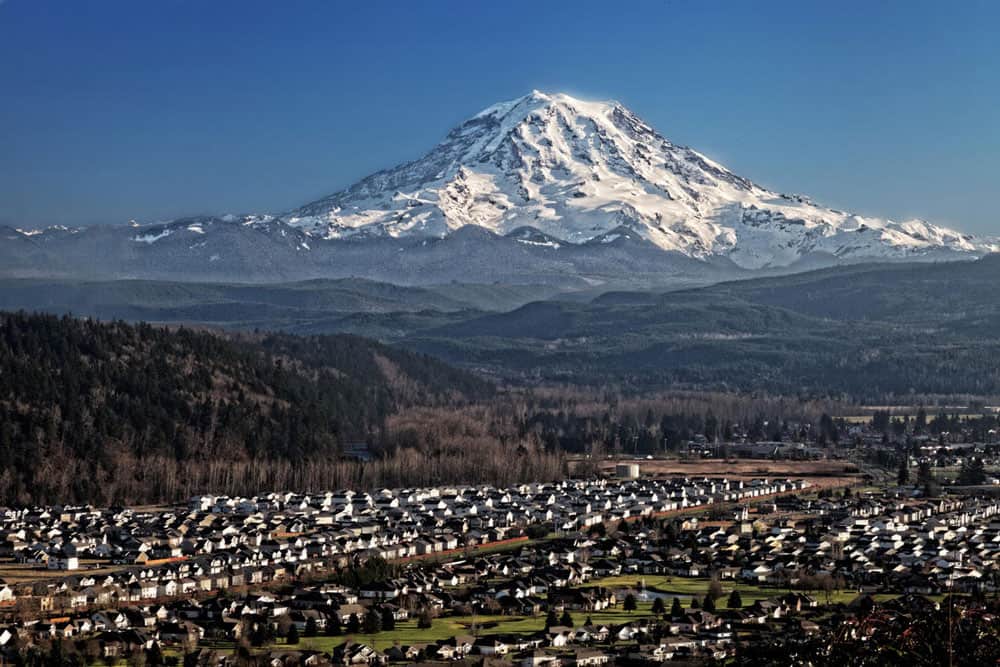
Washington
Mount Rainier: 14,411 feet (4,395)
Mount Rainier is the highest mountain in the Cascade Range and lies about 60 miles (95 kilometers) south-southeast of the city. Due to the regions frequent rainy and cloudy weather, on clear days locals will declare “the mountain is out!” The highest point on Mount Rainier is Columbia Crest.

Mount Rainier, an active stratovolcano, is the most glaciated summit in the contiguous United States, generating five main rivers. Mount Rainier contains 26 glaciers, which hold more snow and ice than the rest of the Cascade volcanoes combined.
Because of its tremendous height, frequent earthquakes, active hydrothermal system, and vast glacier mantle, the USGS considers Mount Rainer to be the most potentially dangerous volcano in the Cascade Range. Mount Rainer has not produced a significant eruption in the last 500 years.
West Virginia
Spruce Knob: 4,863 feet (1,483 meters)
Spruce Knob is West Virginia’s highest point. There is a stone and steel observation tower that sits on top of the summit of Spruce Mountain, part of the Allegheny Mountains. Spruce Mountain lies within the Spruce Knob-Seneca Rocks National Recreation Area.
Despite the lower elevation (under 5,000 feet), Spruce Mountain’s relic boreal forest gives the summit a more distinctly alpine feel compared to other mountains the the southern Appalachians.
Wisconsin
Timms Hill:
1,951 feet (595 meters)
Wisconsin’s highest natural point is Timms Hill in Hill, a town in Price County. Timms Hill is part of the Timms Hill County Park, making it accessible to the public for various outdoor activities. An observation tower at the site provides visitors with a 30-mile view of the surrounding area. Visitors can climb the tower to enjoy panoramic views of the surrounding Wisconsin Northwoods.
Timms Hill is part of the Wisconsin Upland, an area characterized by hilly terrain formed by glacial deposits. This region’s landscape is a result of the last glacial period, which sculpted much of Wisconsin’s current topography.
Wyoming
Gannett Peak: 13,804 feet (4,210 meters)
Wyoming’s highest natural point is located in the northern Wind River Mountain Range. Gannett Peak is the highest peak in the Rocky Mountains outside of Colorado. The peak falls on the boundary between Fremont and Sublette counties. Gannett Peak is part of the Bridger-Teton National Forest and lies within the Bridger Wilderness area.
At 896 acres Gannett Glacier is the largest single glacier in the Rocky Mountains. Gannett Peak straddles the North American continental divide which runs through the Wind River Mountain Range.
List of Highest Point for Every U.S. State From Highest to Lowest
| Rank | State | Highest point | County or subdivision | Elevation (feet) | |
| 1 | Alaska | Denali (Mount McKinley) | – – | 20,320 | |
| 2 | California | Mount Whitney | Inyo-Tulare | 14,494 | * |
| 3 | Colorado | Mount Elbert | Lake | 14,433 | |
| 4 | Washington | Mount Rainier | Pierce | 14,411 | |
| 5 | Wyoming | Gannett Peak | Fremont | 13,804 | |
| 6 | Hawaii | Pu’u Wēkiu, Mauna Kea | Hawaii | 13,796 | |
| 7 | Utah | Kings Peak | Duchesne | 13,528 | |
| 8 | New Mexico | Wheeler Peak | Taos | 13,161 | |
| 9 | Nevada | Boundary Peak | Esmeralda | 13,140 | |
| 10 | Montana | Granite Peak | Park | 12,799 | |
| 11 | Idaho | Borah Peak | Custer | 12,662 | |
| 12 | Arizona | Humphreys Peak | Coconino | 12,633 | |
| 13 | Oregon | Mount Hood | Clackamas-Hood River | 11,239 | |
| 14 | Texas | Guadalupe Peak | Culberson | 8,749 | |
| 15 | South Dakota | Black Elk Peak (Harney Peak) | Pennington | 7,242 | |
| 16 | North Carolina | Mount Mitchell | Yancey | 6,684 | |
| 17 | Tennessee | Clingmans Dome | Sevier | 6,643 | |
| 18 | New Hampshire | Mount Washington | Coos | 6,288 | |
| 19 | Virginia | Mount Rogers | Grayson-Smyth | 5,729 | |
| 20 | Nebraska | Panorama Point | Kimball | 5,424 | |
| 21 | New York | Mount Marcy | Essex | 5,344 | |
| 22 | Maine | Mount Katahdin | Piscataquis | 5,268 | |
| 23 | Oklahoma | Black Mesa | Cimarron | 4,973 | |
| 24 | West Virginia | Spruce Knob | Pendleton | 4,863 | |
| 25 | Georgia | Brasstown Bald | Towns-Union | 4,784 | |
| 26 | Vermont | Mount Mansfield | Chittenden | 4,393 | |
| 27 | Kentucky | Black Mountain | Harlan | 4,145 | |
| 28 | Kansas | Mount Sunflower | Wallace | 4,039 | |
| 29 | South Carolina | Sassafras Mountain | Pickens | 3,560 | |
| 30 | North Dakota | White Butte | Slope | 3,506 | |
| 31 | Massachusetts | Mount Greylock | Berkshire | 3,491 | |
| 32 | Maryland | Hoye Crest | Garrett | 3,360 | |
| 33 | Pennsylvania | Mount Davis | Somerset | 3,213 | |
| 34 | Arkansas | Magazine Mountain | Logan | 2,753 | |
| 35 | Alabama | Cheaha Mountain | Cleburne | 2,407 | |
| 36 | Connecticut | Mount Frissel on south slope at State line | Litchfield | 2,380 | |
| 37 | Minnesota | Eagle Mountain | Cook | 2,301 | |
| 38 | Michigan | Mount Arvon | Baraga | 1,979 | |
| 39 | Wisconsin | Timms Hill | Price | 1,951 | |
| 40 | New Jersey | High Point | Sussex | 1,803 | + |
| 41 | Missouri | Taum Sauk Mountain | Iron | 1,772 | |
| 42 | Iowa | Hawkeye Point | Osceola | 1,670 | |
| 43 | Ohio | Campbell Hill | Logan | 1,550 | |
| 44 | Indiana | Hoosier Hill | Wayne | 1,257 | |
| 45 | Illinois | Charles Mound | Jo Daviess | 1,235 | |
| 46 | Rhode Island | Jerimoth Hill | Providence | 812 | |
| 47 | Mississippi | Woodall Mountain | Tishomingo | 806 | |
| 48 | Louisiana | Driskill Mountain | Bienville | 535 | |
| 49 | Delaware | On Ebright Road at Delaware-Pennsylvania State line | New Castle | 448 | * |
| 50 | District of Columbia | Tenleytown at Reno Reservoir | – – | 410 | |
| 51 | Florida | Britton Hill | Walton | 345 |
What are highpointers?
An interesting side note is that “highpointers” are people that visit every high point in every U.S. state.
References
Blanchard, N. (2023, July 11). Elevation for the tallest mountain in Idaho is actually higher than we thought. Idaho Statesman. https://www.idahostatesman.com/outdoors/article277038083.html
This article was originally written August 19, 2021 and has since been updated.