
Oklahoma! It is not only a musical. It is also a state. Oklahoma is the only state in America whose state song is a musical show tune.
Wheat, wind, and a hawk are all mentioned in the song. The prairie is also mentioned in the song’s lyrics. The song contains references to Oklahoma’s topography. This song has references to weather, biogeography, and physical geography. However, this is only a small portion of what Oklahoma has to offer in terms of its land.
Where is Oklahoma Located?
Oklahoma ranks 19th in size of all the U.S. states according to land area with 68,679 square miles. Oklahoma’s relative location is in the southern-central portion of the United States of America. In clockwise order starting north, Oklahoma borders six other states: Kansas, Missouri, Arkansas, Texas, New Mexico, and Colorado. The states of that Oklahoma borders is also reflected in its geography.

Oklahoma’s Topography
Oklahoma is often associated with the Great Plains. It is something well-noted in the song Oklahoma! While this is certainly a major part of the state’s geography, there are many different landforms within its borders.
Southeastern Oklahoma is home to the Kiamichi Mountains. When some people think of Oklahoma, mountains are often the last thing that ever comes up. In fact, Oklahoma is home to several small mountain ranges.
The Kiamichi Mountains are part of the Ouachita Mountains, which are also located in southeastern Oklahoma. The Ouachita Mountains are also part of neighboring Arkansas. This part of Oklahoma is also referred to as Kiamichi Country and Choctaw Country. The latter name is in honor of the Choctaw Nation, one of the federally recognized Native American groups in the United States of America. The Choctaw nation has its headquarters in Durant, Oklahoma. Ouachita National Forest, Oklahoma’s only national forest, is part of this region.
Highest Point in Oklahoma
Black Mesa, located in northwest Cimarron County, Oklahoma, is the state’s highest point at 4,973 feet (1,516 meters).
Lowest Point in Oklahoma
While southeast Oklahoma is the most mountainous part of the state, it is also home to Oklahoma’s lowest point. At 289 feet above sea level, the lowest point in Oklahoma is located on the Little River in McCurtain County (the southernmost and easternmost county in Oklahoma).
Oklahoma and Alligators
The American alligator is found in McCurtain and Choctaw counties. These are the only places in Oklahoma that are part of the biogeographic range of the American alligator.
No National Parks in Oklahoma
Oklahoma is one of just twenty states without a National Park.
Northeast Oklahoma
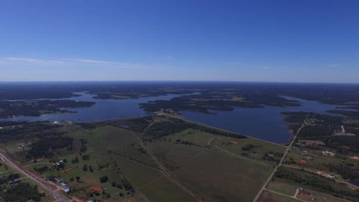
Northeast Oklahoma is known as Green Country. The Ozark Mountains are a major physical feature of this reason. And true to its name, this is a region of forests. Forests consisting of deciduous and evergreen trees make up a major portion of this region. This is a region of rolling hills and a higher proportion of lakes than elsewhere in the state.
Most of Oklahoma’s lakes are reservoirs. Oklahoma has over 200 reservoirs, more than any other state.

Green Country’s largest city is also Oklahoma’s second largest city, Tulsa. The Arkansas River, which flows through Green Country, passes through Tulsa. Green Country is home to two ocean-going ports, the Tulsa Port of Catoosa, and the Port of Muskogee. Both ports are part of the McClellan-Kerr Arkansas River Navigation System. The head of navigation starts at the Tulsa Port of Catoosa, northeast of Tulsa along the Verdigris River.
Oil is a major part of Oklahoma’s economy. Oil was discovered at Glenpool Oil Reserve, just south of Tulsa. This discovery is what made Tulsa a major oil hub in Oklahoma. The discovery of the Glenpool Oil Reserve also resulting in the founding of the nearby suburb of Glenpool.
The further west one goes within Oklahoma, the land starts to change. There are fewer forests and woodlands and prairies become more prominent. The Cross Timbers region is that transition between the wetter, more forested regions of Oklahoma and the relatively drier regions dominated by prairies. Woodlands and prairies mix in this region.
The Cross Timbers often serves as a boundary for the biogeographic ranges of certain plants and animals. The region touches both of Oklahoma’s largest metropolitan areas. The far west fringes of the Tulsa metropolitan area are part of the Cross Timbers region, while Tulsa itself is part of Green Country. Some of the northeastern area of the Oklahoma City metropolitan area are located within the Cross Timbers. The Cross Timbers region also represents a human divide.
Capital of Oklahoma
Oklahoma City is the capital of Oklahoma, and the state’s largest city. It is the anchor of Oklahoma’s largest metropolitan area. The Oklahoma City metropolitan area is along the edge of the Cross Timbers region.
Oklahoma City was founded in 1889 when thousands of people seeking land settled in the region during the Land Run of 1889. Within one decade, over 10,000 people lived in Oklahoma City. Today, Oklahoma City has 655,000 people.
Oklahoma City has gone from a major livestock city to an oil producing city. The metropolitan area has around 1.4 million people. Areas west of the Oklahoma City and the Cross Timbers have markedly less populated than areas east of the Cross Timbers.
South-Central Oklahoma
The southern-central region of Oklahoma is home to the Arbuckle Mountains and the Red River Valley (not to be confused with the Red River Valley of the North in North Dakota/Minnesota). The Red River forms the border between Oklahoma and Texas. The Arbuckle Mountains are actually a range of hills. Turner Falls is located within the Arbuckle Mountains. At 77 feet, this is Oklahoma’s highest waterfall.
Southwest Oklahoma
Southwest Oklahoma is a region of prairies. It is part of the Great Plains. Grasslands and gently rolling hills are characteristic of this region.
While its prairies make up much of the region’s landscapes, there are several isolated hills and mountains within the area, known as sky islands. The Wichita Mountains are the most prominent of the region’s sky island ranges.
The Wichita Mountains are part of the Wichita Mountains Wildlife Refuge. Bison (the state mammal), elk, owls, and river otters are just some of the animals found within the wildlife refuge. Standing out from the grasslands of southwest Oklahoma, the Wichita Mountains contain mixed oak forests. The Bigtooth maple, normally found in the higher elevations of the Intermountain West, lives among the Wichita Mountains.
Northwest Oklahoma’s geography is very reminiscent of the southwestern USA. Mesas, canyons, and grasslands make up much of the region’s landforms. By elevation, this is the highest region on Oklahoma. The state’s highest elevation is within the Oklahoma Panhandle. Oklahoma’s portion of Black Mesa is at an altitude of 4,973 feet above sea level, making it the loftiest place in Oklahoma. Black Mesa is located not only in Oklahoma, but in New Mexico and Colorado.
Tornado Alley
Oklahoma’s location makes it a breeding ground for tornadoes. It is part of the aptly named Tornado Alley. Oklahoma is situated where cold air from the Rocky Mountains and Canada collides with warm, moist air from the Gulf of Mexico. Dry air from nearby New Mexico also plays a role in forming tornadoes. The dry air prevents storms from getting too much precipitation, thus helping to build up a tornado.

Oklahoma’s Diverse Geography
Geographically, Oklahoma is a transition zone in the western United States between wetter, forested parts and drier regions. Oklahoma is unmistakably a Great Plains state. Geographically, it is also diverse. Oklahoma’s topography includes forests, mountains, prairies, rivers, lakes, canyons, and mesas.
References
American alligator (Alligator mississippiensis) – Species profile. (n.d.). Nonindigenous Aquatic Species. https://nas.er.usgs.gov/queries/FactSheet.aspx?speciesID=221
Cross timbers remain a unique Oklahoma feature. (2014, October 10). Norman Transcript. https://www.normantranscript.com/news/cross-timbers-remain-a-unique-oklahoma-feature/article_a93eb54f-d411-55f9-9b0d-4f5f39d0cc0e.html
Glenpool history. (n.d.). Glenpool, OK | Official Website. https://www.glenpoolonline.com/238/Glenpool-History
Glenn pool Field | The Encyclopedia of Oklahoma history and culture. (n.d.). Oklahoma Historical Society. https://www.okhistory.org/publications/enc/entry.php?entry=GL007
Layden, L. (2012, September 27). Why Oklahoma built more lakes than any other state. StateImpact Oklahoma | Environment, Education, Energy, Health And Justice: Policy to People. https://stateimpact.npr.org/oklahoma/2012/09/27/why-oklahoma-built-more-lakes-than-any-other-state/
McClellan-Kerr Arkansas River Navigation System. (n.d.). Tulsa District, U.S. Army Corps of Engineers. https://www.swt.usace.army.mil/Missions/Navigation/