

The original thirteen states occupied only a fraction of the land that makes up today’s United States. As new states entered the Union, the nation expanded to include an extraordinary range of landscapes, from the Great Plains and Rocky Mountains to deserts, temperate rainforests, Arctic tundra, coral reefs, and tropical islands.
Why is Delaware called the First State?
Delaware became the first state on December 7, 1787, when it became the first to ratify the U.S. Constitution. Because of this, Delaware is known as “The First State.”
What was the last state admitted to the United States?
Hawaii became the 50th state on August 21, 1959, a few months after Alaska joined the Union.
What was the first state that was not one of the original thirteen colonies?
Vermont became the 14th state on March 4, 1791, making it the first state admitted after the original thirteen colonies.
Which states were admitted in 1889?
Four states joined the Union in 1889:
- North Dakota
- South Dakota
- Montana
- Washington
This was one of the busiest years for state admissions.
How many states are in the United States?
The United States has 50 states. Hawaii became the 50th state in 1959.
Key milestones in U.S. state admissions
| Milestone | State | Date |
|---|---|---|
| First state | Delaware | December 7, 1787 |
| First non-original colony | Vermont | March 4, 1791 |
| 25th state | Arkansas | June 15, 1836 |
| 48th contiguous state | Arizona | February 14, 1912 |
| 49th state | Alaska | January 3, 1959 |
| 50th state | Hawaii | August 21, 1959 |
Timeline of states in order of admission
Explore the complete timeline of all 50 states, including when each entered the Union, along with satellite imagery and key geographic facts.
1. Delaware
1787: December 7 (Ratification date – one of the original U.S. colonies)
Delaware is known as the First State because it was the first state to ratify, or sign, the United States Constitution. Delaware has the lowest average elevation of any state, averaging about 60 feet (18 meters) above sea level.
| Capital | Dover |
| Area | 1,982 mi2 (5,130 km2) 49th rank |
| Mean Elevation | 60 ft (20 m) Lowest in US |
| Highest Elevation | Near the Ebright Azimuth: 447.85 ft (136.50 m) |
| % of State Area that is water | 21.5 |

2. Pennsylvania
1787: December 12 (Ratification date – one of the original U.S. colonies)
The term “Keystone State” comes from the fact that Pennsylvania forms a geographic bridge between the Northeastern and Southern United States, as well as the Atlantic and Midwest coasts. Pennsylvania spans five major physiographic regions, from the Lake Erie Plain and Appalachian Plateau to the Ridge and Valley, Piedmont, and Atlantic Coastal Plain, giving it one of the most varied landscapes in the eastern United States.
| Capital | Harrisburg |
| Area | 46,055 mi2 (119,283 km2) 33rd rank |
| Mean Elevation | 1,100 ft (340 m) |
| Highest Elevation | Mount Davis: 3,213 ft (979 m) |
| % of State Area That is Water | 2.7 |

3. New Jersey
1787: December 18 (Ratification date – one of the original U.S. colonies)
Large portions of New Jersey’s northwestern and southern regions are very rural. The fertile, loamy soil of the state’s Inner Coastal Plain area makes the terrain suitable for agriculture, earning New Jersey the nickname “Garden State”.
| Capital | Trenton |
| Area | 8,722.58 mi2 (22,591.38 km2) 47th rank |
| Mean Elevation | 250 ft (80 m) |
| Highest Elevation | High Point: 1,803 ft (549.6 m) |
| % of State Area That is Water | 15.7 |

4. Georgia
1788: January 2 (Ratification date – one of the original U.S. colonies)
Georgia was the last and southernmost of the original Thirteen Colonies to be established. Georgia became the fourth state to ratify the United States Constitution on January 2, 1788.
Georgia stretches from the Blue Ridge Mountains in the north to the Atlantic Coastal Plain in the south. The state is also home to the Okefenokee Swamp, one of North America’s largest intact freshwater wetlands.
| Capital | Atlanta |
| Area | 59,425 mi2 (153,909 km2) 24th rank |
| Mean Elevation | 600 ft (180 m) |
| Highest Elevation | Brasstown Bald: 4,784 ft (1,458 m) |
| % of State Area that is Water | 2.6 |

5. Connecticut
1788: January 9 (Ratification date – one of the original U.S. colonies)
Connecticut is the southernmost state in the United States’ New England area. State nicknames for Connecticut include “Constitution State”, the “Nutmeg State”, the “Provisions State”, and the “Land of Steady Habits”.
The Connecticut River, New England’s longest river, flows south through the center of the state before emptying into Long Island Sound. Connecticut’s landscape ranges from rocky uplands to coastal marshes.
| Capital | Hartford |
| Area | 5,567 mi2 (14,357 km2) 48th rank |
| Mean Elevation | 500 ft (150 m) |
| Highest Elevation | MA border on south slope of Mount Frissell: 2,379 ft (725 m) |
| % of State Area that is Water | 12.6 |

6. Massachusetts
1788: February 6 (Ratification date – one of the original U.S. colonies)
Nicknames for Massachusetts are: The Bay State (official), The Pilgrim State; The Puritan State, The Old Colony State, and The Baked Bean State.
Massachusetts spans a surprising variety of landscapes, from the Berkshire Mountains in the west to Cape Cod’s sandy peninsula and the islands of Martha’s Vineyard and Nantucket.
| Capital | Boston |
| Area | 10,565 mi2 (27,337 km2) 44th rank |
| Mean Elevation | 500 ft (150 m) |
| Highest Elevation | Mount Greylock: 3,489 ft (1,063.4 m) |
| % of State Area That is Water | 25.7 |

7. Maryland
1788: April 28 (Ratification date – one of the original U.S. colonies)
The Chesapeake Bay divides Maryland nearly in half and has shaped the state’s geography, economy, and settlement for centuries. Maryland is also the only U.S. state with no natural lakes.
| Capital | Annapolis |
| Area | 12,407 mi2 (32,133 km2) 42nd rank |
| Mean Elevation | 350 ft (110 m) |
| Highest Elevation | Hoye-Crest: 3,360 ft (1,024 m) |
| % of State Area That is Water | 21 |

8. South Carolina
1788: May 23 (Ratification date – one of the original U.S. colonies)
South Carolina’s landscape is divided into three major physiographic regions: the Atlantic Coastal Plain, the Piedmont, and the Blue Ridge Mountains. Along the coast, barrier islands, tidal marshes, and estuaries create one of the most extensive coastal ecosystems on the Atlantic seaboard. The state is also home to the ACE Basin, one of the largest undeveloped estuaries in the United States.
| Capital | Columbia |
| Area | 32,020 mi2 (82,931 km2)40th rank |
| Mean Elevation | 350 ft (110 m) |
| Highest Elevation | Sassafras Mountain: 3,560 ft (1,085 m) |
| % of State Area That is Water | 6 |

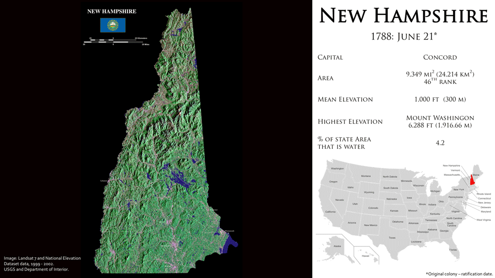
9. New Hampshire
1788: June 21 (Ratification date – one of the original U.S. colonies)
The nickname, “The Granite State” comes from the New Hampshire’s large granite rocks and quarries. With a general coastline length of 18.57 miles (29 km), New Hampshire has the shortest ocean coastline of any U.S. coastal state.
| Capital | Concord |
| Area | 9,349 mi2 (24,214 km2) 46th rank |
| Mean Elevation | 1,000 ft (300 m) |
| Highest Elevation | Mount Washington: 6,288 ft (1,916.66 m) |
| % of State Area That is Water | 4.2 |
10. Virginia
1788: June 25 (Ratification date – one of the original U.S. colonies)
Virginia stretches from the Atlantic Coastal Plain to the Appalachian Plateau across five distinct physiographic provinces. Hampton Roads forms the only natural entrance to Chesapeake Bay and is one of the world’s finest natural harbors. The state’s diverse landscapes range from barrier islands and tidal marshes to the Blue Ridge Mountains and the rugged Appalachian Plateau.
| Capital | Richmond |
| Area | 42,774.2 mi2 (110,785.67 km2)35th rank |
| Mean Elevation | 950 ft (290 m) |
| Highest Elevation | Mount Rogers 5,729 ft (1,746 m) |
| % of state Area that is water | 7.4 |

11. New York
1788: July 26 (Ratification date – one of the original U.S. colonies)
New York’s geography ranges from the Atlantic Coastal Plain and Hudson Valley to the Adirondack Mountains, Great Lakes, and Niagara Escarpment. The state is home to Adirondack Park, the largest publicly protected area in the contiguous United States, while New York City, with more than 8.3 million residents, is the nation’s most populous city.
| Capital | Albany |
| Area | 54,555 mi2 (141,300 km2) 27th rank |
| Mean Elevation | 950 ft (290 m) |
| Highest Elevation | Mount Marcy: 5,344 ft (1,629 m) |
| % of State Area That is Water | 13.5 |

12. North Carolina
1789: November 21 (Ratification date – one of the original U.S. colonies)
North Carolina stretches from the Outer Banks and Atlantic barrier islands to the Blue Ridge Mountains. The waters off Cape Hatteras have claimed more than a thousand ships since records began in 1526, earning the area the nickname “Graveyard of the Atlantic.”
| Capital | Raleigh |
| Area | 53,819 mi2 (139,390 km2) 28th rank |
| Mean Elevation | 700 ft (210 m) |
| Highest Elevation | Mount Mitchell: 6,684 ft (2,037 m) |
| % of State Area That is Water | 9.5 |
More: Geography of North Carolina

13. Rhode Island
1790: May 29 (Ratification date – one of the original U.S. colonies)
Rhode Island is the smallest U.S. state by area. The “Ocean State” is Rhode Island’s official nickname, referring to the extensive bays and inlets that make up around 14% of the state’s total territory.
| Capital | Providence |
| Area | 1,214 mi2 (3,144 km2) 50th rank |
| Mean Elevation | 200 ft (60 m) |
| Highest Elevation | Jerimoth Hill: 812 ft (247 m) |
| % of State Area That is Water | 13.9 |
More: Geography Facts: Rhode Island

14. Vermont
1791: March 4 (Vermont is the first state not part of the original 13 U.S. colonies to become part of the United States).
After the 13 colonies were ratified, Vermont became the 14th state admitted to the newly formed United States of America. Not counting steeple heights, Vermont is the only U.S. state without a building taller than 124 feet.
The Green Mountains extend the length of Vermont, dividing the state’s watersheds. Lake Champlain forms much of Vermont’s western border and is one of the largest freshwater lakes in the United States.
| Capital | Montpelier |
| Area | 9,616 mi2 (24,923 km2) 45th rank |
| Mean Elevation | 1,000 ft (300 m) |
| Highest Elevation | Mount Mansfield: 4,395 ft (1,340 m) |
| % of State Area That is Water | 4.1 |

15. Kentucky
1792: June 1
Kentucky is known as the “Bluegrass State” because of the Kentucky bluegrass grass that grows in many of the state’s pastures. Mammoth Cave National Park, the world’s longest cave system, is located in Kentucky.
| Capital | Frankfort |
| Area | 40,409 mi2 (104,659 km2) 37th rank |
| Mean Elevation | 750 ft (230 m) |
| Highest Elevation | Black Mountain: 4,145 ft (1,263 m) |
| % of State Area That is Water | 1.7 |

16. Tennessee
1796: June 1
| Capital | Nashville |
| Area | 42,143 mi2 (109,247 km2)36th rank |
| Mean Elevation | 900 ft (270 m) |
| Highest Elevation | Clingmans Dome 6,643 ft (2,025 m) |
| % of state Area that is water | 2.2 |

17. Ohio
1803: March 1
The state flag of Ohio is the only non-rectangular flag in the United States. Ohio is named after the Ohio River, whose name comes from the Seneca word ohiyo’, which means “good river,” “big river,” or “huge stream.”
Ohio’s landscape reflects the last Ice Age. Glaciers flattened much of the north, while the unglaciated southeast is characterized by rolling hills and deeply dissected valleys.
| Capital | Columbus |
| Area | 44,825 mi2 (116,096 km2)34th rank |
| Mean Elevation | 850 ft (260 m) |
| Highest Elevation | Campbell Hill 1,549 ft (472 m) |
| % of state Area that is water | 8.7 |

18. Louisiana
1812: April 30
Louisiana’s southern coast is one of the world’s fastest-disappearing regions. Climate change, oil and gas drilling and dredging, and Mississippi River levees are causing the state to lose a football field of land every 48 minutes, or 16 square miles each year.
| Capital | Baton Rouge |
| Area | 52,378.13 mi2 (135,382 km2) 31st rank |
| Mean Elevation | 100 ft (30 m) |
| Highest Elevation | Driskill Mountain: 535 ft (163 m) |
| % of State Area That is Water | 15 |

19. Indiana
1816: December 11
With the highest point at 1,257 feet (383 m) and the lowest point at 320 feet (98 m), Indiana has the narrowest elevation span, 937 feet (286 m) of any non-coastal US state.
| Capital | Indianapolis |
| Area | 36,418 mi2 (94,321 km2) 38th rank |
| Mean Elevation | 700 ft (210 m) |
| Highest Elevation | Hoosier Hill: 1,257 ft (383 m) |
| % of state Area that is water | 1.5 |

20. Mississippi
1817: December 10
Mississippi lies almost entirely within the Gulf Coastal Plain, with the fertile Mississippi Alluvial Plain stretching along the state’s western border.
| Capital | Jackson |
| Area | 48,430 mi2 (125,443 km2) 32nd rank |
| Mean Elevation | 300 ft (90 m) |
| Highest Elevation | Woodall Mountain 807 ft (246.0 m) |
| % of State Area That is Water | 3.0 |

21. Illinois
1818: December 3
Except for a few locations where the Mississippi River has changed course, the river forms nearly the entire western boundary of Illinois. Together with the Ohio River to the south, it defines much of the state’s borders.
| Capital | Springfield |
| Area | 57,953 mi2 (149,967 km2) 25th rank |
| Mean Elevation | 600 ft (180 m) |
| Highest Elevation | Charles Mound: 1,235 ft (376.4 m) |
| % of State Area That is Water | 3.99 |

22. Alabama
1819: December 14
Alabama has the most inland waterways of any state, with about 1,500 miles (2,400 km) of navigable rivers and streams. The state stretches from the Appalachian foothills to the Gulf Coastal Plain.
| Capital | Montgomery |
| Area | 52,419 mi2 (135,765 km2) 30th rank |
| Mean Elevation | 500 ft (150 m) |
| Highest Elevation | Mount Cheaha: 2,413 ft (735.5 m) |
| % of State Area That is Water | 3.20 |
More: A to Z Geography: Alabama

23. Maine
1820: March 15
Maine is the contiguous United States’ northeasternmost state. Maine is also the only state with a single syllable name, and the only state that only borders one other state. Maine’s rugged Atlantic coastline is deeply indented by bays, peninsulas, and thousands of islands. Inland, dense forests cover nearly 90% of the state, making it the most heavily forested state in the contiguous United States.
| Capital | Augusta |
| Area | 35,385 mi2 (91,646 km2) 39th rank |
| Mean Elevation | 600 ft (180 m) |
| Highest Elevation | Mount Katahdin: 5,270 ft (1,606.4 m) |
| % of State Area That is Water | 13.5 |

24. Missouri
1821: August 10
Missouri is one of only two states that borders eight other states; Tennessee is the other. The Missouri and Mississippi rivers converge just north of St. Louis, creating one of North America’s most significant river confluences. Southern Missouri is dominated by the Ozark Plateau, where soluble limestone has produced an extensive karst landscape containing more than 7,500 recorded caves, hundreds of large springs, sinkholes, and underground streams. The St. Francois Mountains expose some of the oldest rocks on the continent, while the southeastern corner of the state lies within the New Madrid Seismic Zone, the source of the powerful earthquakes of 1811 and 1812.
| Capital | Jefferson City |
| Area | 69,704 mi2 (180,530 km2) 21st rank |
| Mean Elevation | 800 ft (244 m) |
| Highest Elevation | Taum Sauk Mountain: 1,772 ft (540 m) |
| % of State Area That is Water | 1.17 |

25. Arkansas
1836: June 15
The world’s only diamond-bearing place accessible to the public for digging is Crater of Diamonds State Park near Murfreesboro, Arkansas.
| Capital | Little Rock |
| Area | 53,180 mi2 (137,733 km2)29th rank |
| Mean Elevation | 650 ft (200 m) |
| Highest Elevation | Mount Magazine 2,753 ft (839 m) |
| % of state Area that is water | 2.09 |

26. Michigan
1837: January 26
Michigan is the only state in the United States that is made up of two peninsulas: the Lower Peninsula and the Upper Peninsula. Michigan is flanked by four of the five Great Lakes, as well as Lake St. Clair, making it the state with the longest freshwater shoreline in the United States.
| Capital | Lansing |
| Area | 96,716 mi2 (250,493 km2) 11th rank |
| Mean Elevation | 900 ft (270 m) |
| Highest Elevation | Mount Arvon: 1,979 ft (603 m) |
| % of State Area That is Water | 41.5 |

27. Florida
1845: March 3
In the contiguous United States, Florida has the longest coastline. Florida’s coastline stretches 1,350 miles from one end to the other (2,170 km). Related: Interesting Geography Facts About Florida
| Capital | Tallahassee |
| Area | 65,755 mi2 (170,304 km2) 22nd rank |
| Mean Elevation | 100 ft (30 m) |
| Highest Elevation | Britton Hill: 345 ft (105 m) |
| % of State Area That is Water | 17.9 |
More: Interesting Geography Facts About Florida

28. Texas
1845: December 29
Texas is the largest state in the contiguous United States and the second largest overall after Alaska. Three of Texas’ borders are defined by rivers: the Rio Grande is a natural border with parts of Mexico, the Red River forms a natural border with Oklahoma and Arkansas to the north, and the Sabine River forms a natural border with Louisiana to the east.
| Capital | Austin |
| Area | 268,581 mi2 (696,241 km2) 2nd rank |
| Mean Elevation | 1,700 ft (520 m) |
| Highest Elevation | Guadalupe Peak: 8,751 ft (2,667.4 m) |
| % of State Area That is Water | 2.5 |

29. Iowa
1846: December 28
On the west Iowa is bordered by the Missouri River and the Big Sioux River and by the Mississippi River on the east, making it the only state with east and west borders formed almost entirely by rivers. The Loess Hills contain one of the world’s largest deposits of windblown silt (loess).
More: Geography of Iowa
| Capital | Des Moines |
| Area | 56,272.81 mi2 (145,746 km2) 26th rank |
| Mean Elevation | 1,100 ft (340 m) |
| Highest Elevation | Hawkeye Point: 1,671 ft (509 m) |
| % of State Area That is Water | 0.70 |

30. Wisconsin
1848: May 29
Wisconsin’s landscape was shaped by glaciers during the last Ice Age, leaving behind thousands of lakes and nearly every major type of glacial landform, including kettles, drumlins, eskers, moraines, and outwash plains. The state borders both Lake Michigan and Lake Superior, the two largest Great Lakes by surface area. Along the Lake Superior shoreline, the Apostle Islands contain one of the world’s largest concentrations of freshwater sea caves.
| Capital | Madison |
| Area | 65,498.37 mi2 (169,640 km2) 23rd rank |
| Mean Elevation | 1,050 ft (320 m) |
| Highest Elevation | Timms Hill: 1,951 ft (595 m) |
| % of State Area That is Water | 17 |
More: A to Z Geography: Wisconsin

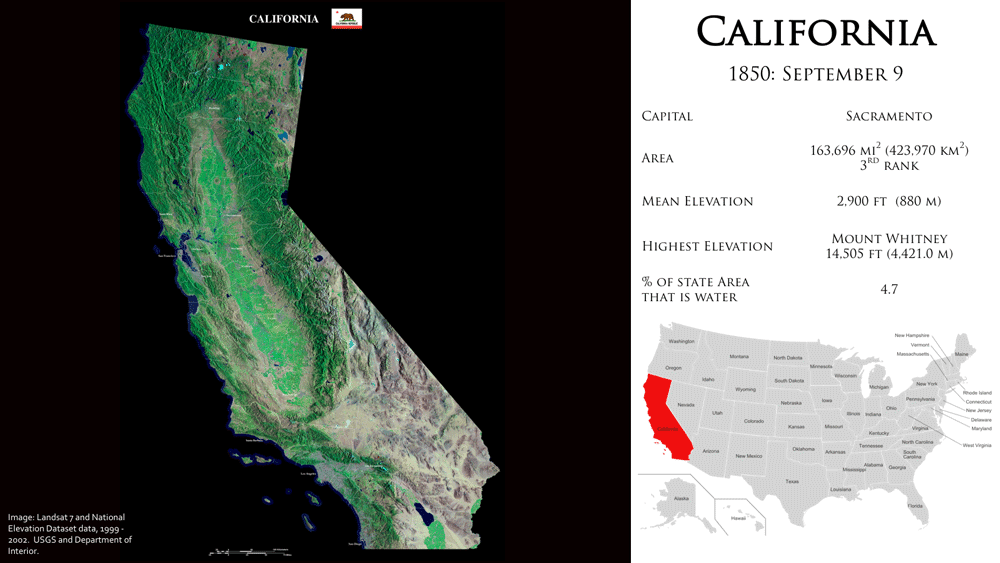
31. California
1850: September 9
Both the highest (Mount Whitney) and lowest (Death Valley) points in the 48 contiguous states are found in California. California is the most populous and the third-largest state in terms of area in the United States.
| Capital | Sacramento |
| Area | 163,696 mi2 (423,970 km2) 3rd rank |
| Mean Elevation | 2,900 ft (880 m) |
| Highest Elevation | Mount Whitney: 14,505 ft (4,421.0 m) |
| % of State Area That is Water | 4.7 |
32. Minnesota
1858: May 11
About one-third of Minnesota is forested, and the state is known as the “Land of 10,000 Lakes” because it contains more than 11,800 lakes that are at least 10 acres (4 hectares) in size. Minnesota is one of the few places in North America where water ultimately flows to three continental drainage basins: Hudson Bay, the Gulf of Mexico, and the Atlantic Ocean via the Great Lakes. Unlike Montana’s Triple Divide Peak, where the three watersheds meet at a single mountain summit, Minnesota’s divides extend across broad areas of the state.
| Capital | Saint Paul |
| Area | 86,936 mi2 (225,163 km2) 12th rank |
| Mean Elevation | 1,200 ft (370 m) |
| Highest Elevation | Eagle Mountain: 2,301 ft (701 m) |
| % of State Area That is Water | 8.40 |

33. Oregon
1859: February 14
Oregon spans an extraordinary range of landscapes, from the Pacific coastline and temperate rainforests to the Cascade volcanoes, high desert, and semi-arid shrublands. Crater Lake, formed when Mount Mazama collapsed about 7,700 years ago, is the deepest lake in the United States.
| Capital | Salem |
| Area | 98,381 mi2 (254,806 km2) 9th rank |
| Mean Elevation | 3,300 ft (1,000 m) |
| Highest Elevation | Mount Hood: 11,249 ft (3,428.8 m) |
| % of State Area That is Water | 2.4 |

34. Kansas
1861: January 29
The geographic center of the contiguous United States lies near Lebanon in Smith County, Kansas. Kansas is also farther from an ocean than any other U.S. state. Kansas is home to the Flint Hills, which contain the largest remaining expanse of tallgrass prairie in North America.
| Capital | Topeka |
| Area | 82,278 mi2 (213,100 km2) 15th rank |
| Mean Elevation | 2,000 ft (610 m) |
| Highest Elevation | Mount Sunflower: 4,041 ft (1,232 m) |
| % of State Area That is Water | 0.6 |
More: Geography of Kansas

35. West Virginia
1863: June 20
The nickname The Mountain State and the motto Montani Semper Liberi (“Mountaineers are always free”) come from the fact that Virginia is almost entirely mountainous. West Virginia is the only state located entirely within the Appalachian Mountain region, giving it some of the most rugged terrain in the eastern United States.
Related: West Virginia’s First National Park
| Capital | Charleston |
| Area | 24,230 mi2 (62,755 km2) 41st rank |
| Mean Elevation | 1,513 ft (461 m) |
| Highest Elevation | Spruce Knob: 4,863 ft (1,482 m) |
| % of State Area That is Water | 0.6 |

36. Nevada
1864: October 31
Nevada has 172 named mountain peaks that rise above 2,000 feet (610 meters), more than any state except Alaska. It is the most mountainous state in the contiguous United States, with more than 300 named mountain ranges separated by broad desert basins.
| Capital | Carson City |
| Area | 110,577 mi2 (286,382 km2) 7th rank |
| Mean Elevation | 5,500 ft (1,680 m) |
| Highest Elevation | Boundary Peak: 13,147 ft (4,007.1 m) |
| % of State Area That is Water | 0.72 |

37. Nebraska
1867: March 1
Nebraska is the only triply landlocked state in the United States. Much of north-central Nebraska is covered by the Sandhills, the largest stabilized dune field in the Western Hemisphere. Formed by wind during the last Ice Age, the grass-covered dunes overlie the Ogallala Aquifer, one of the world’s largest groundwater resources.
| Capital | Lincoln |
| Area | 77,358 mi2 (200,365 km2) 16th rank |
| Mean Elevation | 2,600 ft (790 m) |
| Highest Elevation | Panorama Point: 5,424 ft (1,654 m) |
| % of State Area That is Water | 0.7 |

38. Colorado
1876: August 1
Colorado is known as the “Centennial State” because it became a state 100 years after the Declaration of Independence. It also has the highest average elevation of any U.S. state and is home to 58 peaks above 14,000 feet (4,267 meters), known as “fourteeners.” In Colorado’s southwest corner, the Four Corners Monument marks the only place in the United States where four states meet, at 36°59’56″N, 109°2’43″W.
| Capital | Denver |
| Area | 104,094 mi2 (269,837 km2) 8th rank |
| Mean Elevation | 6,800 ft (2,070 m) |
| Highest Elevation | Mount Elbert in Lake County: 14,440 ft (4,401.2 m) |
| % of State Area That is Water | 0.36 |

39. North Dakota
1889: November 2 (admitted at the same time as South Dakota)
The KVLY-TV mast near Blanchard is the tallest man-made structure in the Western Hemisphere. The “Geographic Center of the North American Continent” is marked near Rugby. In western North Dakota, the Little Missouri River carved the rugged Badlands.
| Capital | Bismarck |
| Area | 71,230 mi2 (183,640 km2) 19th rank |
| Mean Elevation | 1,900 ft (580 m) |
| Highest Elevation | White Butte: 3,508 ft (1,069 m) |
| % of State Area That is Water | 2.4 |

40. South Dakota
1889: November 2 (admitted at the same time as North Dakota)
The geographic center of the United States, including Alaska and Hawaii, is near the town of Belle Fourche in South Dakota. The Black Hills rise abruptly from the surrounding Great Plains and are home to Black Elk Peak, the highest point east of the Rocky Mountains.
| Capital | Pierre |
| Area | 78,116 mi2 (199,729 km2) 17th rank |
| Mean Elevation | 2,200 ft (670 m) |
| Highest Elevation | Black Elk Peak: 7,244 ft (2,208 m) |
| % of State Area That is Water | 1.7 |

41. Montana
1889: November 8
Montana is the only state that borders three Canadian provinces: British Columbia, Alberta, and Saskatchewan. The Continental Divide follows the crest of the Rocky Mountains through western Montana. At Triple Divide Peak in Glacier National Park, water can ultimately flow to the Pacific Ocean, the Gulf of Mexico, or Hudson Bay, making it one of the few places in North America where three continental drainage basins meet.
More: Geography of Montana
| Capital | Helena |
| Area | 147,040 mi2 (380,800 km2)4th rank |
| Mean Elevation | 3,400 ft (1,040 m) |
| Highest Elevation | Granite Peak 12,807 ft (3,903.5 m) |
| % of state Area that is water | 1 |

42. Washington
1889: November 11
Washington spans an extraordinary range of landscapes, from the Pacific coastline and temperate rainforests to the Cascade Range and the arid Columbia Plateau. At 14,411 feet (4,392 meters), Mount Rainier is the state’s highest peak and the most glaciated mountain in the contiguous United States. Mount Rainier is also an active stratovolcano.
| Capital | Olympia |
| Area | 71,362 mi2 (184,827 km2) 18th rank |
| Mean Elevation | 1,700 ft (520 m) |
| Highest Elevation | Mount Rainier: 14,411 ft (4,392 m) |
| % of State Area That is Water | 6.6 |

43. Idaho
1890: July 3
Idaho is dominated by rugged mountain ranges, deep river canyons, and vast forests. The United States Forest Service manages about 38 percent of the state’s land, the highest percentage of any state. In western Idaho, Hells Canyon is the deepest river gorge in the United States. Flowing unimpeded for 425 miles (684 km), the Salmon River is the longest free-flowing river system contained entirely within a single state in the contiguous United States. Along its course, the river drops more than 7,000 feet (2,130 meters), cutting through some of the most rugged and remote terrain in the American West.
| Capital | Boise |
| Area | 83,797 mi2 (216,900 km2) 14th rank |
| Mean Elevation | 5,000 ft (1,520 m) |
| Highest Elevation | Borah Peak: 12,662 ft (3,859 m) |
| % of State Area That is Water | 0.98 |

44. Wyoming
1890: July 10
Wyoming is the least populous and least densely populated state in the contiguous United States. Nearly half of Wyoming is federally owned, including Yellowstone and Grand Teton national parks.
| Capital | Cheyenne |
| Area | 97,914 mi2 (253,600 km2) 10th rank |
| Mean Elevation | 6,700 ft (2,040 m) |
| Highest Elevation | Gannett Peak: 13,809 ft (4,209.1 m) |
| % of State Area That is Water | 0.7 |
More: A to Z Geography: Wyoming

45. Utah
1896: January 4
Utah is one of only three states in the United States (Utah, Colorado, and Wyoming) that use latitude and longitude lines as their boundaries. Utah is the only state in which national forest land is found in every county. Utah spans three major physiographic regions: the Rocky Mountains, Colorado Plateau, and Basin and Range Province. The state is also home to the Great Salt Lake, the largest saltwater lake in the Western Hemisphere.
| Capital | Salt Lake City |
| Area | 84,899 mi2 (219,653 km±) 13th rank |
| Mean Elevation | 6,100 ft (1,860 m) |
| Highest Elevation | Kings Peak: 13,534 ft (4,120.3 m) |
| % of State Area That is Water | 3.25 |

46. Oklahoma
1907: November 16
The Arbuckle Mountains, Wichita Mountains, Ozark Mountains, and Ouachita Mountains are Oklahoma’s four main mountain ranges. Oklahoma has the highest number of reservoirs in the nation. Oklahoma contains more than a dozen distinct ecological regions, ranging from the High Plains and gypsum hills to forests, mountains, and cypress swamps. This diversity gives Oklahoma one of the widest ranges of landscapes in the central United States.
Related: Geography of Oklahoma

47. New Mexico
1912: January 6
Santa Fe, New Mexico’s state capital is the oldest in the United States and was founded in 1610 as the then as the government seat of Nuevo México. New Mexico is shaped by the Rio Grande Rift, a geologic feature that extends the length of the state. The rift separates mountain ranges and high desert basins while continuing to influence the state’s landscape.
| Capital | Santa Fe |
| Area | 121,699 mi2 (315,198 km2) 5th rank |
| Mean Elevation | 5,700 ft (1,740 m) |
| Highest Elevation | Wheeler Peak: 13,167 ft (4,013.3 m) |
| % of State Area That is Water | 0.2 |

48. Arizona
1912: February 12
Arizona was the last contiguous state admitted to the United States. The state spans two major physiographic regions: the Colorado Plateau in the north and the Basin and Range Province in the south. The Colorado River carved the Grand Canyon, one of the world’s largest canyons.
| Capital | Phoenix |
| Area | 113,990 mi2 (295,234 km2) 6th rank |
| Mean Elevation | 4,100 ft (1250 m) |
| Highest Elevation | Humphreys Peak: 12,637 ft (3,852 m) |
| % of State Area That is Water | 0.35 |

49. Alaska
1959: January 3
Alaska is the largest state in the United States and has more coastline than all of the other U.S. states combined. The state is also home to the country’s ten highest mountains. Sitka is the largest city in the United States by area.
| Capital | Juneau |
| Area | 663,268 mi2 (1,717,856 km2) 1st rank |
| Mean Elevation | 1900 ft (580 m) |
| Highest Elevation | Denali: 20,310 ft (6,190.5 m) |
| % of State Area That is Water | 13.77 |
More: Geography of Alaska

50. Hawaii
1959: August 21
Hawaii is the only state in the tropics, the only state outside of North America, and the only state made up completely of islands. The Hawaiian Islands were formed by a volcanic hotspot in the Pacific Plate, and the Island of Hawaiʻi continues to grow as lava reaches the sea.
| Capital | Honolulu |
| Area | 10,931 mi2 (28,311 km2) 43rd rank |
| Mean Elevation | 3,030 ft (920 m) |
| Highest Elevation | Mauna Kea: 13,796 ft (4,205.0 m) |
| % of State Area That is Water | 41.2 |

Video: States in order of admission to the United States
Follow the admission of all 50 states in chronological order as the United States grew from a narrow strip of Atlantic colonies into a nation stretching from the Arctic to the tropics. Watch the companion video on YouTube: States in order of admission to the United States
