

Alaska, the largest state in the United States, is located in the extreme northwest of North America. It is bordered by the Arctic Ocean to the north, the Pacific Ocean to the south and southwest, and Canada to the east.
Alaska has a diverse landscape that includes rugged mountains, vast glaciers, boreal forests, tundra, and a long coastline. The state is known for its vast size and natural beauty, with numerous national parks and wildlife refuges.
The geography of Alaska is shaped by its location at the edge of the continent, as well as by its harsh climate and unique geological features.
Alaska is remote
Located in the far northwestern section of North America, Alaska is part of the United States of America, while being physically removed from it. No U.S. state shares a border with Alaska.

The eastern border of Alaska is shared with the Yukon Territory and the province of British Columbia in Canada. This gives Alaska the distinction of being the U.S. state bordered only by another country.
Only Hawaii, an archipelago state in the middle of the Pacific Ocean, has more remoteness among American states. The nearest U.S. state to Hawaii on America’s mainland is Washington state, at least 570 miles from border to border.
Alaska: the “Last Frontier”
Alaska’s remote location isn’t the only reason it is the Last Frontier. Alaska is the largest of the U.S. states. Its total land area is 586,412 square miles.
Alaska makes up 15.4% of the total land area of the United States.
Northern, Western, and Eastern Alaska
Alaska’s southernmost point is Amatignak Island, located at 51° 15′ 44” N. Its northernmost latitude is Point Barrow, 71° 23′ 25”. For this reason, Alaska is home to the northernmost point in the United States of America (and North America) Alaska is the only state with land north of the Arctic Circle.
Easternmost and westernmost point in the United States
Alaska is also home to the westernmost AND easternmost points in the United States of America: Attu Island.

Easternmost point on land by longitude in the United States
At 179° 46’ E, this is the easternmost point on land by longitude in the United States. The line of longitude at 180 degrees is the dividing line between eastern longitudes and western latitudes.
Semisopochnoi Island lies slightly west of that line, making it by definition, the most eastern point of the United States (51°57′05″N 179°36′03″E).

Semisopochnoi Island is a volcanic island located in the western Aleutian Islands chain of Alaska, United States. It is approximately 11 miles (18 kilometers) in wide and 12 miles (20 kilometers) miles wide, with a total area of about 86 square miles (222 square kilometers).
Semisopochnoi Island is part of the Alaska Maritime National Wildlife Refuge and is uninhabited except for occasional field researchers.
The island has two main peaks: Anvil Peak, which is the highest point at 6,902 feet, and an active volcano called Mount Cerberus, which has erupted multiple times in the past century, with the most recent eruption occurring in 2018. The volcano is monitored by the Alaska Volcano Observatory, which tracks seismic activity and issues warnings for potential eruptions.
Amatignak Island
In addition to being Alaska’s southernmost point, Amatignak Island is also Alaska’s westernmost (and America’s westernmost) point by longitude (51°15′44″N 179°06′31″W).
Alaska’s Main Peninsulas
Alaska can be described as a large peninsula with smaller peninsulas. Most of Alaska is surrounded by water on three sides. These are the largest of Alaska’s peninsulas:
Alaska Peninsula
The Alaska Peninsula is a long, narrow landmass that extends from the mainland of Alaska in the northwestern part of the United States, and it is part of the Aleutian Range. The peninsula is approximately 497 miles long (about 800 kilometers) and is bordered by the Pacific Ocean to the south and southwest, and the Bering Sea to the north and west.
The highest peak is on the Alaska Peninsula is Mount Veniamin, an active volcano that rises to 8,225 feet (2,507 meters)
Seward Peninsula
Seward Peninsula, in western Alaska, surrounded by the Norton Sea, Bering Strait, Chukchi Sea, and the Kotzebue Sound.
The peninsula is approximately 220 miles long and 130 miles wide, and is bordered by the Chukchi Sea to the north and the Bering Sea to the south.
The region is also home to several national and state parks, including the Cape Krusenstern National Monument, the Bering Land Bridge National Preserve, and the Kobuk Valley National Park.

Seward Peninsula is considered a remnant of the Bering land bridge, which used to connect Alaska with Siberia. The land bridge was instrumental in humans traveling from Asia to North America.
Kenai Peninsula
This peninsula, located in southern/central Alaska, is located south of Anchorage. There are several fjords (long, coastal inlets) on this peninsula.
The peninsula is approximately 150 miles long and 100 miles wide, and is bordered by the Cook Inlet to the west and the Gulf of Alaska to the south.

The peninsula is home to several national and state parks, including Kenai Fjords National Park, Chugach National Forest, and Kachemak Bay State Park.
Southeast Alaska
In a state known for extreme cold, southeastern Alaska stands out. Relative to most of the state, southeastern Alaska, has a milder, rainy climate. This is due to its proximity to the Gulf of Alaska.
Ocean currents flow northward to the region, making maritime waters warmer than they would be at such a northern latitude. This creates an oceanic climate.
This region receives among the highest amounts of precipitation in America. Its mountainous areas receive large amounts of snow, while lower elevations tend to get high rainfall totals.
Juneau, Ketchikan, and Sitka are the largest cities of this region. Juneau is the capital of Alaska. This state capital cannot be reached by automobile. There are no roads leading to Juneau.
The extremely rugged terrain surrounding Juneau makes building a road to Juneau nearly impossible. Shifting glaciers also make building a road impractical. In order to get into Juneau, a boat or airplane is required.

Alexander Archipelago
Southeast Alaska is home to the Alexander Archipelago, consisting of over 1000 islands. Two of these islands are Chichagof and Baranof. Those two islands are where the city of Sitka is located. Sitka is the oldest city in Alaska, founded by Russian explorers in 1799.

Another notable island of the Alexander Archipelago is Revillagigedo. This is where the city of Ketchikan is located. Ketchikan is Alaska’s southernmost city. Being a maritime city, Ketchikan is a major commercial fishing center. In fact, the sobriquet of “Salmon Capital of Alaska” is bestowed upon this city, reflecting its salmon industry.
Given its wet, relatively mild climate, southeast Alaska is characterized by temperate rainforest, in particular, Northern Pacific coastal forests. Hemlocks, cedars, spruces, and pines make up a large portion of the trees within southeastern Alaska’s forests.
This region is home to the Tongass National Forest. At nearly 17 million acres, this is the largest national forest in the United States. The Tongass NF makes up the majority of Southeast Alaska.
The state tree of Alaska is the Sitka spruce, a coniferous tree found among the temperate rainforests of southeast Alaska. It is fitting that it shares its name with a city that formerly served as Alaska’s capital.
Southcentral Alaska
Southcentral Alaska refers to the region spanning from the St. Elias Mountains (along the U.S. Canada border) to the central region of the Gulf of Alaska.
Several mountain ranges make up a large portion of this region. The Alaska Range is the longest range in the region. It’s also the highest mountain range in North America.
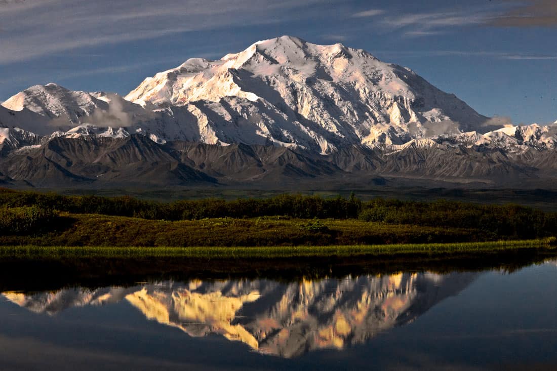
Denali is the loftiest summit of the Alaska Range. At an elevation of 20,130 feet above sea level, Denali is the highest mountain in Alaska, the United States, and in North America.
Deservedly, Denali comes from a Koyukon word for “tall”. Denali is such a high and large mountain, that it manages to create its own localized weather. Weather can change rapidly due to storms from the ocean meeting the behemoth that is Denali.
Other mountain ranges in the region include the Talkeetna, Chugach, Wrangell, Aleutian, Tordrillo, and Kenai mountain ranges.
South-central Alaska is home to several volcanoes, especially in the Wrangell Mountains. The Wrangell Volcanic Field is part of the Wrangell Mountains and the St. Elias Mountains.
In addition to being home to North America’s highest mountain, the USA’s highest volcano, Mount Bona, is located in this region.
Southcentral Alaska is the most populated region of Alaska. Anchorage, along the Cook Inlet, is the largest city in Alaska. It is the northernmost city with at least 250,000+ people. With a land area of at least 1700 square miles, Anchorage is physically larger than the state of Rhode Island.

Anchorage is Alaska’s main transportation hub. On the Knik Arm of the Cook Inlet is the Port of Alaska, Anchorage’s deep water port.
The Port of Alaska is crucial to the state. Goods bound for locations within Alaska often go through the Port of Alaska. The port is home to three cargo terminals, and two terminals which handle petroleum products.
Anchorage is also a major flight hub. Located between Asia and the contiguous 48 states, Ted Stevens International Airport is a major stopover. Cargo aircraft traveling between Asia and North America will often refuel in Anchorage.
Sandwiched in the nearby Chugach, Talkeetna, and Alaska mountain ranges is the Matanuska-Susitna Valley. This valley is part of the Anchorage metropolitan area, home to cities such as Palmer and Wasilla. The valley was formed as a result of glacial activity.
Cabbage is grown in the Matanuska-Susitna Valley. Due to the long summer days, a result of its northernly location, cabbage grown in the valley will often grow to large sizes.
Southwest of Anchorage is the Kenai Peninsula. The Kenai Mountains make up much of the eastern side of the peninsula. Fjords are a major land feature of this peninsula.
Kenai Fjords National Park is located within the peninsula and the Kenai Mountains. The less rugged western side of the peninsula consists of towns such as Soldotna, Homer, and Kenai. Kenai Peninsula is surrounded by Cook Inlet to its west and Prince William Sound to its east.

One significant feature of Prince William Sound is Port Valdez. Sharing its name with the city located in the area, Port Valdez is an mountain-ringed inlet. The Trans-Alaska Pipeline terminates along its shores, at the Valdez Marine Terminal.
Southwest Alaska
Southeast Alaska isn’t the only part of the state with an archipelago. The southwest region of Alaska spans a group of islands, the Aleutian Archipelago. There are at least fourteen main islands that are part of the archipelago, and fifty-five smaller islands.
There are also many islets that are part of this chain of islands. Some of the islands are located west of the 180th line of longitude, including Semisopochnoi, the easternmost location within the USA.
The largest island, Attu, is the westernmost of the island, and the westernmost location within the USA. Currently, Attu is the largest uninhabited island to be part of the United States. Sea otters and several species of sea birds are among the wildlife that are found on these islands.
Aleutian Islands

The Aleutian Islands are part of the Aleutian Arc. The Aleutian Arc is a volcanic belt in southwestern Alaska. Like the Aleutian Peninsula to the east, there are a high concentration of volcanoes.
Some of the volcanoes of southwestern Alaska include Mount Redoubt, Novarupta, and Mount Katmai. Mount Katmai and Novarupta are among several volcanoes within Katmai National Park and Preserve.
True to its volcanic nature, this national park is home to the Valley of Ten Thousand Smokes. Novarupta’s 1912 eruption resulted in the valley being covered in volcanic ash. Steam emanated from the underground fumaroles.

Pribilof Islands
The Aleutian Islands aren’t the only volcanic islands of southwest Alaska. North of the Aleutian Islands are the Pribilof Islands. The two main islands of this archipelago are St. Paul and St. George.
Theses islands are also known as the Northern Fur Seal Islands. There are more northern fur seals breeding in the Pribilof Islands than anywhere else in the world. The seals gather here during the summer to give birth to new fur seal pups.
These islands aren’t only a gathering place for northern fur seals. Millions of birds, in particular, seabirds, flock to the islands as well.
Kodiak Island
Southeast of the Aleutian Peninsula is Kodiak Island. This is the second largest island in the United States, and Alaska’s largest. The island has a land area of 3595 sq mi. Mountains and forests make up much of the island.
The Kodiak bear is indigenous to the island. Much of Kodiak Island, along with other nearby islands, is part of the Kodiak National Wildlife Refuge.

Yukon-Kuskokwim Delta
Islands are just one part of southwest Alaska’s physical geography. The Yukon and Kuskokwim rivers are a major part of southwest Alaska’s geography. Both rivers empty into the Bering Sea. This is where the Yukon-Kuskokwim Delta is located.
The Yukon-Kuskokwim River Delta is one of the largest river deltas in the world, with an area spanning over 50,000 square miles. Much of this region consists of tundra and wetlands.
The wildlife that live in this region include musk oxen, moose, Canadian lynx, brown bears, black bears, walruses, seals, and sea otters. Beluga whales are found in the nearby Bering Sea. Several species of waterfowl fly to the region to breed.
Fittingly, the Yukon Delta National Wildlife Refuge is located here. This is the second largest National Wildlife Refuge in the United States of America.
Alaska’s Interior
The Interior region is roughly defined as being between the Alaska Range to the south and the Brooks Range to the north. This is a region of vast forests, permafrost, wetlands and valleys.

The Yukon River empties into the Bering Sea. Its watercourse starts in Canada (in the Canadian province of British Columbia) and flows through central Alaska.
The Yukon River Basin is a large portion of central Alaska, also known as the Interior. This geographic basin consists of several valleys bound by many mountain ranges. One of those valleys is the Tanana Valley.
North of the Alaska Range is the Tanana Valley. The Interior of Alaska is a thinly populated region. Extreme cold and permafrost make settlement of this region difficult. Fairbanks (population 32,000), the second largest city in Alaska, is the valley’s largest city.
Other cities within the Tanana Valley include College (where University of Alaska-Fairbanks is located), Chena Hot Springs, and ironically, North Pole. North Pole was named such in the hopes of attracting a toy manufacturing company to set up shop in the region.
The Interior region has an extreme climate with very cold winters. The region’s valley have among the warmest summers in Alaska. This includes Fairbanks. Temperatures have been known to reach the 90s Fahrenheit in Fairbanks. It is also a region of relatively low precipitation.
The Interior sits at a transition zone. Its climate varies from humid continental (cool summer) to subarctic.
Boreal forests, known as taiga, are abundant in Alaska’s Interior, and throughout much of Alaska. Taiga is a biome that consists of coniferous trees such as spruce, pine, and larch. Birch, a broadleaf deciduous tree, is also part of the taiga biome in Alaska.
Brooks Range and Alaska’s Far North
The Brooks Range doesn’t have the highest mountains in Alaska. However, it marks a very important geographic divide. The Brooks Range separates the central portion of Alaska from its far north.

The northernmost river drainage divide in North America
The Brooks Range is the northernmost river drainage divide in North America. Rivers flowing north of the mountain range are bound for the Arctic Ocean. Rivers flowing south of the Brooks Range flow towards the Pacific Ocean.
These mountains span from Canada’s Yukon Territory to the east, to northwestern Alaska to the west. The Brooks Range functions as Alaska’s tree line. North of the Brooks Range, it is too cold for trees to grow in abundance.
In addition to representing the northernmost river drainage divide in North America, the USA’s northernmost national park is located in the Brooks Range. Gates of the Arctic National Park and Preserve is located north of the Arctic Circle.
Gates of the Arctic National Park and Preserve is one of the least visited national parks in the USA. Lack of roads leading to the park are a big reason for this. It encompasses some of the northernmost boreal forests in the USA.
Alaska’s Far North
North of the Brooks Range is Alaska’s Far North. Tundra and mountain ranges characterize the landscape in this region. Owing to the Arctic Ocean (and being north of the Arctic Circle) to its north, this region is also known as Arctic Alaska.
Being the northernmost region in Alaska (and the USA), this region has an arctic climate. Its winters are extremely cold, and its summers are short and cool. Utqiagvik (formerly known as Barrow) is the largest city in this region, as well as the northernmost settlement in the USA.
Utqiagvik is a difficult city to travel to. The continuous permafrost characteristic of the tundra makes building paved roads prohibitive. There is no roads that lead to or from Utqiagvik. Goods often have to be delivered by airplanes.
Yukon Delta National Wildlife Refuge
As mentioned earlier, the Yukon Delta National Wildlife Refuge is the second largest national wildlife refuge in Alaska. The largest NWR is also located in Alaska: Arctic National Wildlife Refuge encompasses part of the Brooks Range and the northeastern corner of Alaska.
Wetlands, lagoons, barrier islands, tundra, mountains, and river deltas are among the landforms that the Arctic NWR helps to protect. This is one part of Alaska where polar bears live.
There are four species of whales that live in the Arctic waters of the NWR. Alaska is home to the Porcupine caribou. It’s name has nothing to do with porcupines, but the Porcupine River of Alaska’s Interior region. In terms of biogeography, the Porcupine caribou lives in the Arctic NWR.
Alaska’s Far North came to prominence in 1968 for an underwater discovery. Petroleum was discovered in Prudhoe Bay. The Prudhoe Bay Oil Field is located west of the Arctic NWR. This discovered spurred the construction of the Trans-Alaska Oil Pipeline, which was completed in 1977.
Permafrost
With Alaska being so far north, this is a region with large amounts of permafrost. The majority of the state (at least 80-85 percent) has permafrost. The permafrost gets thicker with latitude in Alaska. There are many difficulties that come with dealing with permafrost.

In Alaska, there are many places where getting around requires the use of airplanes, snowmobiles, or boats. Permafrost makes building roads difficult in many places.
Permafrost was a major problem in building the Alaska Highway during WWII. Cities like Anchorage and Fairbanks are linked by highways. However, there are many places that cannot be reached by road. Permafrost is one of the factors that makes building roads to certain places difficult.
Another issue that comes with permafrost is construction of buildings. Building on permafrost would prove to be hazardous to both the permafrost and the structures being built. Digging into permafrost would expedite thawing. This would result in subsidence.
As the soil shifts, buildings would shift as well, leading to buildings collapsing. In far northern settlements, such as Utqiagvik, buildings must be built on platforms known as pilings. This helps to preserve the permafrost and keep it from thawing.
In places like the Tanana Valley, permafrost is discontinuous. Some places have and some do not. The soil needs to be inspected before building structures on it. Many structures in Fairbanks were built on permafrost.
Alaska and the Pacific Rim
The Aleutian subduction zone goes through Southern Alaska. The Pacific and North America tectonic plates meet here. The Pacific plate slowly slides under the North American plate. This is known as subduction.
This region is part of the Pacific Ring of Fire. There are a high concentration of earthquakes and volcanoes in the Ring of Fire region.
This is why Alaska has so many volcanoes concentrated in its southern regions. This is the region Alaska has several volcanic islands. There are at least 130 volcanoes in Alaska. About 50 of them are considered to be active volcanoes.

Earthquakes in Alaska
The Ring of Fire is also why Alaska gets many earthquakes. One of the most destructive earthquakes in U.S. history took place near Anchorage.
On March 27, 1964, a mega thrust earthquake took place in southern-central Alaska. This earthquake lasted for 4 minutes, 38 seconds. On the Richter scale, it registered 9.2. At least 131 people were confirmed to have died as a result of the earthquake. Tsunami waves were reported as far away as New Zealand and killed people as far away as California.
Another destructive factor involving the earthquake was soil liquefaction. Alaska has many glaciers in its mountainous areas. Glaciers have pulverized rock under its weight, forming the glacial silt that is ubiquitous in south-central Alaska.
When the earthquake occurred, liquefaction took place. There were also landslides that took place. In the city of Anchorage, height limits on buildings were set as a result of soil liquefaction. The city of Valdez was moved to a different site, on more stable soil.
Alaska’s varied geography
Alaska’s geography is diverse and unique, characterized by vast expanses of rugged wilderness, towering mountains, and expansive coastlines. From the western Aleutian Islands to the southeastern panhandle, the state is home to an incredible array of natural wonders, including glaciers, volcanoes, fjords, and a wide variety of wildlife.
The geography of Alaska is shaped by its location on the edge of the continent, as well as by its harsh climate and unique geological features.
Despite its remote location and challenging environment, Alaska remains a popular destination for adventurers, scientists, and tourists seeking to explore one of the last frontiers on Earth.
References
Carlowicz, M. (2010, December 29). Semisopochnoi island, Alaska. NASA Earth Observatory. https://earthobservatory.nasa.gov/images/48154/semisopochnoi-island-alaska
Ferry, E. (2021, March 13). Road to no road. Southeast Alaska Conservation Council. https://www.seacc.org/road-to-no-road/
Hansen, K. (2016, May 14). Katmai National Park, Alaska. NASA Earth Observatory. https://earthobservatory.nasa.gov/images/88029/katmai-national-park-alaska
Hansen, W. R., Eckel, E. B., Schaem, W. E., Lyle, R. E., George, W., & Chance, G. (1966). The Alaska earthquake, March 27, 1964: field investigations and reconstruction effort(No. 541). US Geological Survey. https://pubs.er.usgs.gov/publication/pp541
Jorgenson, M. T., Yoshikawa, K., Kanevskiy, M., Shur, Y., Romanovsky, V., Marchenko, S., … & Jones, B. (2008, June). Permafrost characteristics of Alaska. In Proceedings of the ninth international conference on permafrost (Vol. 3, pp. 121-122). University of Alaska: Fairbanks.
Kitchenman, A., & Alaska Public Media & KTOO – Juneau. (2016, October 10). Juneau access road proves to be point of contention among officials. Alaska Public Media. https://alaskapublic.org/2016/10/05/juneau-access-road-proves-to-be-point-of-contention-among-officials/
Wallace, W. K., & Hanks, C. L. (1990). Structural provinces of the northeastern Brooks Range, arctic national wildlife refuge, Alaska. AAPG Bulletin, 74(7), 1100-1118. https://doi.org/10.1306/0C9B2425-1710-11D7-8645000102C1865D