
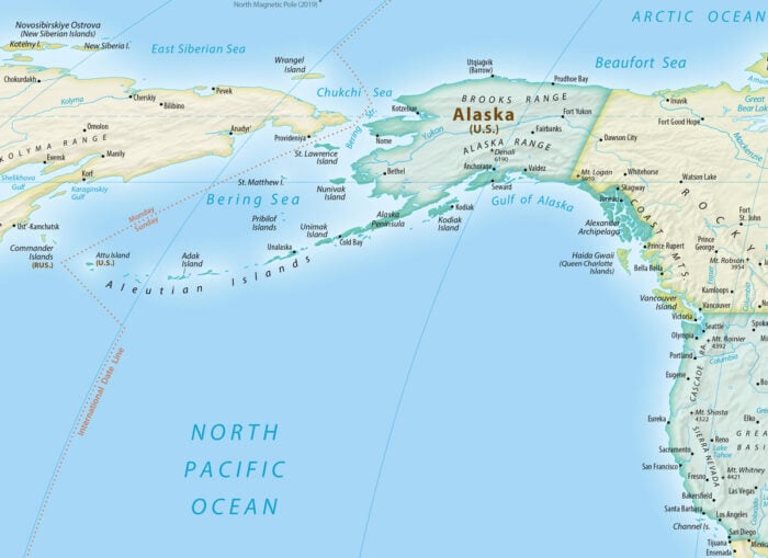
Alaska is a land of geographic extremes. It contains the nation’s highest mountain, more lakes than any other state, and more than 100,000 glaciers and ice fields. Alaska also includes the northernmost, easternmost, and westernmost points in the United States, all shaped by the state’s unusual position and the sweep of the Aleutian Islands.
Another of Alaska’s geographic distinctions is its coastline, the longest of any U.S. state. Stretching across the North Pacific and Arctic oceans and around thousands of islands, its length depends on how closely the coast is measured.
Longest Coastline in the United States
Alaska’s mainland alone gives the state the longest general coastline in the United States. Its 2,670 named islands, the most of any U.S. state, add thousands of miles of additional shoreline, making Alaska’s coastline longer than those of the other 49 states combined.

Alaska has a general coastline of 6,640 miles. When islands, bays, and inlets are included, its shoreline increases to 33,904 miles. More recent NOAA mapping estimates Alaska’s tidal shoreline at more than 46,600 miles, longer than the shorelines of all the lower 48 states combined.
Why do these measurements differ? Imagine tracing Alaska’s coast on a map. A thick marker captures only the general outline, while a fine-tipped marker follows every bay, inlet, island, and curve. The more detail you include, the longer the coastline becomes. This effect is known as the coastline paradox.
Advances in mapping technology now allow scientists to measure Alaska’s coastline in far greater detail than was possible decades ago. At the same time, Alaska’s coast is constantly changing. Erosion, storms, sea ice, thawing permafrost, and rising sea levels continually reshape parts of the shoreline, so scientists regularly update coastal maps using satellite imagery, aerial photography, lidar, and field surveys.
What is the difference between a coastline and a shoreline? A coastline is the general outline of a landmass. A shoreline is the boundary where land meets water. Because shorelines include bays, inlets, islands, and other coastal features, shoreline measurements are typically much longer than coastline measurements.
Stretching from the North Pacific to the Arctic Ocean, Alaska’s coastline borders the Bering, Chukchi, and Beaufort seas. This broad geographic range creates coastal environments that extend from temperate rainforests in the southeast to Arctic tundra in the north.

Approximately 3,095 miles of Alaska’s coastline are protected within national parks and preserves, safeguarding some of the world’s largest intact coastal ecosystems, including glaciers, fjords, estuaries, and critical wildlife habitat.
Geology of Alaska’s Coastlines
Alaska’s approximately 66,000 miles of Arctic and sub-Arctic shoreline encompass glacial fjords, river deltas, barrier islands, volcanic coasts, estuaries, and rocky headlands, making it one of the most geologically diverse coastlines in the world.
Over millions of years, tectonic activity, volcanism, glaciers, rivers, sea-level changes, and sea ice have shaped Alaska’s coastline into the diverse landscape seen today. Those same forces continue to reshape the coast through erosion, thawing permafrost, storms, and shifting sediment. Along Alaska’s Arctic coast, declining sea ice leaves shorelines more exposed to waves and coastal storms, accelerating erosion that threatens communities, critical infrastructure, natural coastal habitats, and cultural resources.
Rugged, rocky coastlines with sheltered fjords characterize southeastern Alaska, while Arctic shorelines feature barrier islands, permafrost bluffs, and broad river deltas. Southeastern Alaska remains largely ice-free year-round because of the moderating influence of the North Pacific Ocean.

Barrier Islands
While there are no barrier islands along the West Coast states of Washington, Oregon, and California, Alaska’s Arctic coastline has 272 barrier islands, accounting for 12.7% of the world’s inventory. These islands buffer Alaska’s Arctic coastline from waves and storms while providing important habitat for birds, marine mammals, and other wildlife. Scientists were surprised to discover so many barrier islands in the Arctic because sea ice and permafrost create coastal conditions very different from those found along temperate coasts. During the summer, retreating sea ice and thawing permafrost expose these islands to waves, wind, and currents that continually reshape them.

Cloudiest Region in the United States
Moist air moving inland from the North Pacific makes southern Alaska the cloudiest region in the United States. Some locations average more than 340 cloudy days each year. Cold Bay is cloudiest in August, when average cloud cover reaches 94.7%.
Animal Life Along Alaska’s Coastlines
The Alexander Archipelago Wolf (also known as the Islands Wolf) dwells in a remote part of Alaska. This little grey coastal wolf inhabits the Alexander Archipelago islands as well as a section of coastline separated by the Coast Mountains.

No other species of geese breeds as far north as the Pacific Brant which has breeding grounds along the coastal tundra of Alaska and Canada.

Alaska’s coastal ecosystems provide habitat for a remarkable variety of predators. Arctic foxes patrol beaches and tundra in search of birds and small mammals, grizzly bears gather along rivers to feed on salmon, and polar bears depend on Arctic sea ice and coastal habitats to hunt seals.

The Pacific Walrus can be found along the mainland coast and islands of Russia and Alaska.
Pacific walruses can be found in the comparatively shallow waters of the northern Bering and Chukchi seas, as well as the Eastern Siberian and Beaufort seas on rare occasions. Walruses can be found in the Bering Sea from the Bering Strait to Bristol Bay in the east, and as far south as the Kamchatka Peninsula in the west. They also use island haulouts in the Pribilof Islands and near St. Lawrence Island.

Multiple species of whales can be seen in the waters off the coasts of Alaska. Humpback, fin, blue, minke, and gray whales live in more southern waters, whereas belugas and bowhead whales live in the Arctic and subarctic.
Alaska’s coastline is dynamic
Alaska’s coastline is one of the world’s most dynamic coastal landscapes. Shaped by glaciers, volcanoes, rivers, sea ice, and powerful ocean processes, it stretches from temperate rainforests to Arctic barrier islands. Its immense size, remarkable diversity, and constantly changing nature continue to make it one of the most scientifically important coastlines on Earth.
References
Coastal and Marine Hazards and Resources Program. (2020, November 30). Coastal change mapping and research in Alaska. U.S. Geological Survey. https://www.usgs.gov/programs/cmhrp/news/coastal-change-mapping-and-research-alaska
Molnia, B. F., Krimmel, R. M., Trabant, D. C., March, R. S., & Manley, W. F. (2008). Glaciers of North America: Glaciers of Alaska (Professional Paper 1386-K). U.S. Geological Survey. https://doi.org/10.3133/pp1386K
National Oceanic and Atmospheric Administration. (2025, January 21). Alaska ShoreZone: Mapping over 46,000 miles of coastal habitat. Office of Response and Restoration. https://response.restoration.noaa.gov/about/media/alaska-shorezone-mapping-over-46000-miles-coastal-habitat.html
National Oceanic and Atmospheric Administration. (1975). The coastline of the United States. U.S. Department of Commerce. NOAA https://shoreline.noaa.gov/link/Coastline_of_the_US_1975.pdf
Stutz, M. L., & Pilkey, O. H. (2011). Open-ocean barrier islands: global influence of climatic, oceanographic, and depositional settings. Journal of Coastal Research, 27(2), 207-222.
This article was originally published June 21, 2021 and has since been updated.
