
Geography Basics
Geography is the study of the Earth’s physical and human features, their spatial relationships, and the processes that shape them. It is a broad and interdisciplinary field that incorporates elements of natural science, social science, and the humanities.
Geographers seek to understand the complex interactions between the natural environment and human societies, and the ways in which these interactions vary across different regions and cultures.
This category contains articles about introductory concepts in geography. Find resources, books, lesson plans, and maps for teaching geography to all ages. A fun way to learn about geography is through the use of quizzes which are also listed in this category.
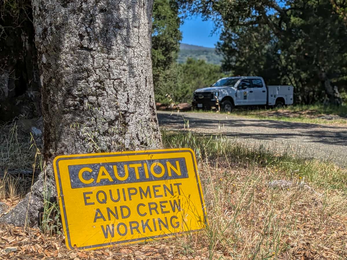
Timing Matters: Spring Mowing, Nesting Birds, and Native Wildflowers at Bear Creek Redwoods Preserve
Midpen says timing matters in grassland management. At Bear Creek Redwoods, spring mowing conflicts with ground nesting birds and blooming wildflowers.

Using Landsat and NDVI to Map Vegetation Change
Landsat imagery and NDVI are used to monitor vegetation change, from invasive grass spread in rangelands to early stress detection in coastal marshes.
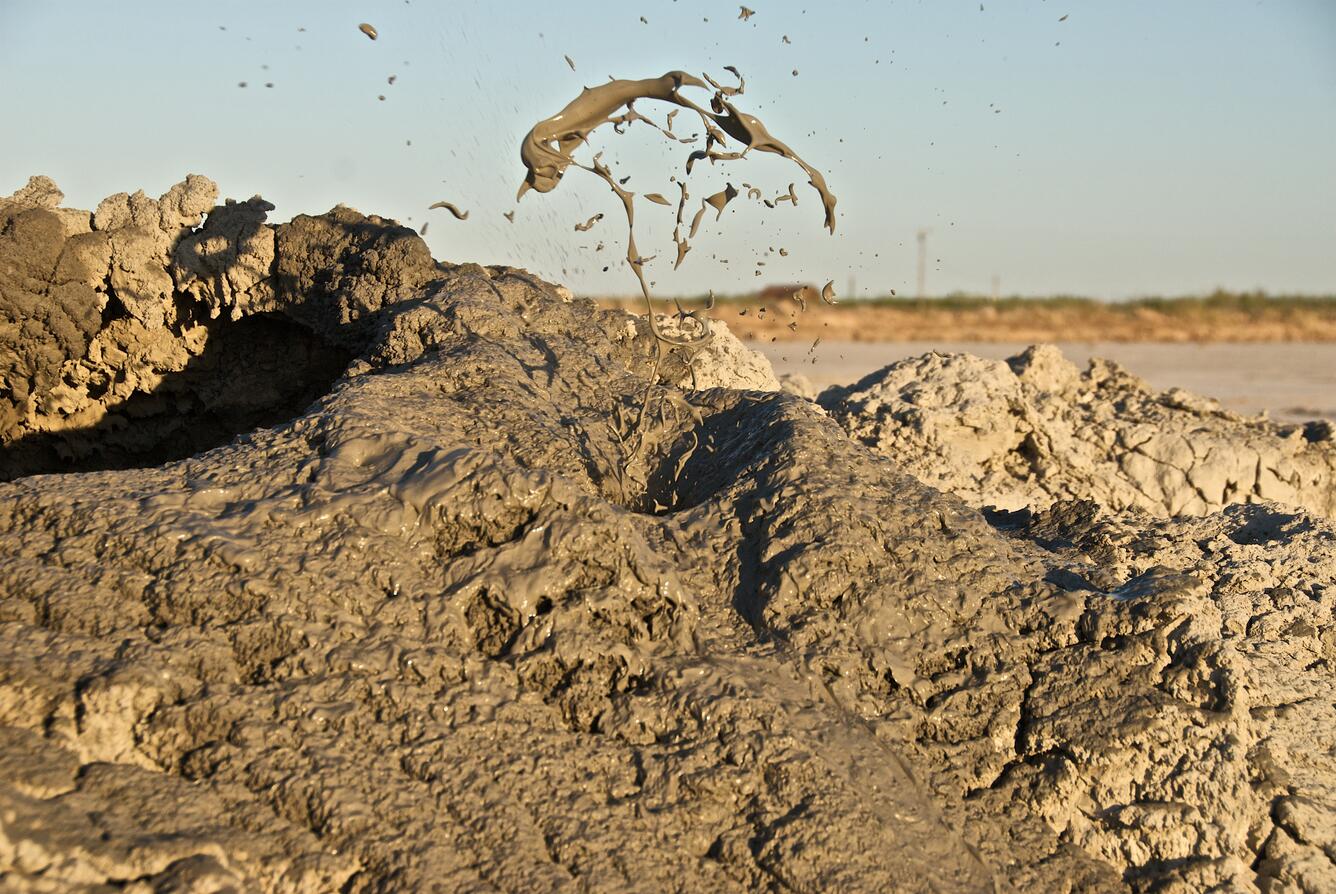
GIS Data: Shallow Sea Mud Volcanoes
A global dataset of 700 mud volcanoes was recently published by geologists from Sapienza University.

Northernmost Point in the United States
Above the Arctic Circle, Point Barrow is the northernmost point in the United States.

Only State… Geography Facts
Here are some interesting geography facts that are unique to individual U.S. states and do not occur in any other state.

Geography Printables
GeographyFun features maps, crosswords, and word searches for educators, students, and geography enthusiasts who love exploring the world through words.

Deep Space Mapping of Saharan Dust Height
Researchers used four years of measurements from a deep space satellite to calculate the average monthly heights of Saharan dust clouds.

Hydroclimate Whiplash: the Impact on California Wildfires
Rapid shifts between extremely dry and unusually wet conditions are reshaping California’s fire landscape by increasing vegetation growth, drying fuels, and contributing to more intense wildfires.

Florida’s Largest Open Water Estuary
Covering an area of about 400 square miles, Tampa Bay is Florida's largest open water estuary.

Sado Island: An Example of Tripartite Geography
Two mountain ranges and a central plain make Sado Island a classic example of tripartite geography.

Isostatic Rebound: How Earth’s Surface Rises after Glaciers Retreat
Isostatic rebound is the Earth's slow rise after glaciers melt, reshaping coastlines, revealing landforms, and altering sea levels globally.

Cavum: Hole-punch Clouds
Cavums are also known as hole-punch clouds or fallstreak holes.

Mapping Methane: the Launch of MethaneSAT and the Limitations of Satellite Data
While advances in remote sensing and satellite technology have improved methane mapping, ground measurements remain essential for accurate, localized data.

Extratropical Cyclones in the United States
Extratropical cyclones are powerful storms forming between 30°–60° latitude, driven by temperature contrasts.

Land Carbon Storage Declined Sharply in 2023
Global land carbon storage saw a significant decline in 2023, driven by extreme droughts, wildfires, and heatwaves.

Storms in the Western Pacific Ocean
The western Pacific experienced a rare event in November 2024 with four simultaneous storms.

Planting Trees in the Arctic May Contribute to Climate Change
Afforestation in Arctic regions may accelerate permafrost thaw, releasing stored carbon and potentially exacerbating climate change.

Desert Dust Triggers Photoplankton Blooms in the Ocean
Saharan dust carries vital nutrients across oceans, triggering phytoplankton blooms that boost marine productivity and influence global carbon cycles.

Pushing the Boundaries of Geospatial: New Books from Esri Press
Three recent publications from Esri Press: Mapping the Deep, The Geography of Hope, and The Power of Where.

Automating a London Tube Style Transit Map of the World
Using OpenStreetMap data, researchers created an automated world transit map with simplified layouts modeled after the London Tube map design.

Study: Cities at Higher Latitudes Benefit More from Urban Vegetation Cooling
Study in Nature Communications examined cooling benefits of urban vegetation in 468 cities to see where parks and greenery benefit residents most.

How Many States Are Along the East Coast and West Coast of the United States?
Learn how many states are along the East Coast and how many states are along the West Coast.
Biases in Measuring Vegetation Greenness with Satellite Imagery
Satellite data is used to map vegetation greenness, but seasonal and sampling biases can distort results, especially in areas with short growing seasons.

Study: 25% of Europe Could Be Rewilded
A study found that about 25% of Europe could benefit from rewilding, the process of restoring natural ecosystems and wildlife.

Regional Changes in Forest Carbon Storage
Global forests have absorbed carbon steadily for 30 years, but deforestation and climate change have affected absorption rates across different biomes.

The Last U.S. Stand of the Key Largo Tree Cactus Has Vanished
The Key Largo tree cactus is now extinct in Florida, highlighting the vulnerability of coastal species to climate change and sea level rise.