
Geography Basics
Geography is the study of the Earth’s physical and human features, their spatial relationships, and the processes that shape them. It is a broad and interdisciplinary field that incorporates elements of natural science, social science, and the humanities.
Geographers seek to understand the complex interactions between the natural environment and human societies, and the ways in which these interactions vary across different regions and cultures.
This category contains articles about introductory concepts in geography. Find resources, books, lesson plans, and maps for teaching geography to all ages. A fun way to learn about geography is through the use of quizzes which are also listed in this category.

Changes in Ice Cover on the Great Lakes
Ice cover on the Great Lakes varies annually depending on factors such as air temperature, wind, and lake depth.

Solutions for Greening Cities
There are various solutions for implementing green infrastructure in cities including the removal of on-street parking to create space for tree planting.

Changes to the Global Water Cycle
Researchers are using Earth observation satellites to track changes to the global water cycle.

Type of Map Perspective: Bird’s Eye
Bird's-eye maps are created from an elevated perspective, showing an area as seen from above.

A to Z Geography: Alabama
Here is an alphabetical list of words that relate to Alabama and its geography.

Wonderful Words to Describe How We Experience Geography
There are some unique words to describe some of how we experience the world around us.

Haboobs in the United States
Haboobs, also known as convectively-driven dust storms, are intense, large-scale dust storms that occur in arid regions in the United States.

Triple Divides in the United States
A triple divide is a point on Earth where water from that location can potentially travel into three different watersheds.

Dams in the United States
There are dams in all 50 U.S. states and over 91,000 dams in all.

Heatwaves are Affecting Rivers in the United States
Heatwaves are having an impact on rivers in the United States.


Understanding Direction Based on the Sun
This lesson plan introduces the concept of direction to young children by using the location of the Sun in order to understand where east, west, north, and south are located.

Medieval Peutinger Map | Book Review
The Peutinger Map (Tabula Peutingeriana) is a unique medieval replica of a Roman route map from the late fourth to early fifth centuries.
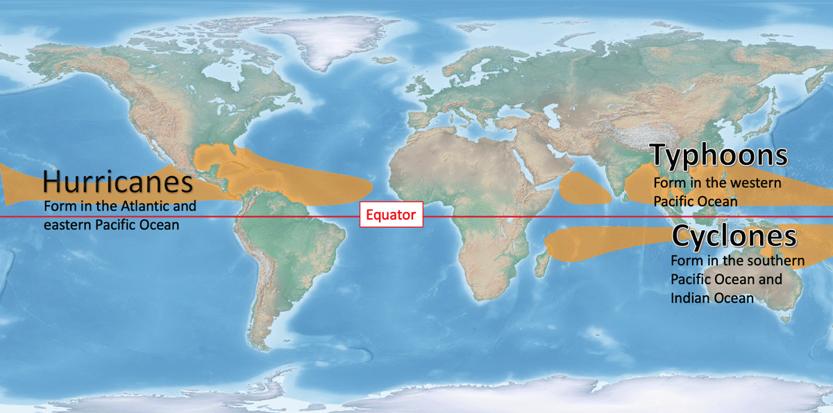
Tropical Cyclones: Hurricanes, Typhoons, and Cyclones
Depending on where the storm system develops, it will be called a hurricane, typhoon, or cyclone.

Geography of the United States
Extreme temperatures, topography, wind, and other powerful natural forces have shaped the geography of the United States.

Which U.S. States are Landlocked?
There are 27 states in the United States that are single, double, or triple landlocked.

Curling Stones Come from Two Quarries in the World
Almost all of the granite harvested to create curling stones comes from a small isle off the coast of mainland Scotland.

Hearts on Earth
Geographers have a spatial way to celebrate Valentine's Day with these natural heart-shaped land features.

How a Changing Climate is Affecting Forests in the Western United States
Drought, more intense fires, and invasive species are changing the forest landscapes in Western United States.

Distance Decay in Geography
Distance decay between two groups of people gives rise to things like languages and regional customs, and distance decay across biomes contributes to the earth's natural diversity.

Test Your Knowledge of World Geography with these Online Games
Geoguesser is an online game that uses images from Google Street View to display a small section of the world.

Largest Plateau in the World
The Qinghai–Tibet Plateau is the world's largest plateau.
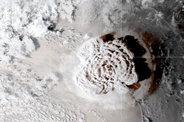
How Big Was the Tonga Volcanic Eruption?
Tonga was rocked by an undersea volcano eruption on January 15, 2022, which sent shockwaves throughout the planet.

Understanding How Carbon Storage Can Help Meet Climate Goals
The storage of carbon is a critical part of rebalancing the carbon cycle to ensure that climate change is less severe than many predict.

Groundwater on Earth
Groundwater can be divide into two major zones: unsaturated and saturated.

Cumbre Vieja Volcano on La Palma Island
Cumbre Vieja, a volcano on the island of La Palma, erupted again on September 19, 2021.