
Cumbre Vieja is a volcano that is located on La Palma, one of the westernmost islands in the Canary Islands archipelago. It began erupting on the 19th September 2021, and at the current time of writing, has erupted continuously for over four weeks.
The eruption is particularly notable due to the length of the event, and because it is the first volcanic activity on the island since 1971.
The eruption of Cumbre Vieja has received a great amount of coverage due to its devastating impacts, with lava flows that have destroyed over a thousand buildings and properties. With a Volcanic Explosivity Index rating of 2, the eruption has not been hugely explosive when compared to many other volcanic events, but has produced some large lava flows.
Earthquakes and ash clouds have also been observed. There is some worry about whether the eruption could trigger landslides, and the possible size and risks of these, but scientists have argued that a large-scale landslide is very unlikely.

What Type of Volcano is Cumbre Vieja?
Like the other volcanoes in the Canary Islands archipelago, Cumbre Vieja is the result of a hotspot underneath the Earth’s crust, and is not formed at a plate boundary. Here, a mantle plume upwells against the oceanic crust of the African Plate, and where magma has broken through the crust, volcanoes have formed.
As the African plate moves slowly north-eastwards, the hotspot has stayed stationery, forming a chain of islands and volcanoes, meaning that the western Canaries are the newest and erupt the most frequently.
This includes La Palma, which only breached the waves of the Atlantic Ocean around 1.8 million years ago, and usually experiences a volcanic eruption on the island every few decades.

Cumbre Vieja is a fissure volcano, part of a large system of linear vents that stretches along the top of a long ridge.
The ridge is located in the southern half of La Palma, running from north to south. Cumbre Vieja has many different vents, which are spread out on the top of the ridge and run halfway down its western side.
At 6,394 feet (1,949 metres) above sea level, the volcano is one of the highest on the island, although the vent which first erupted in 2021 is located at an altitude of around 3,000 feet (900 metres) above the waves of the sea.
The volcano has sides that steeply drop to sea level (and the floor of the Atlantic) on both its western, southern and eastern sides. Non-volcanically active mountains border the volcano to its north.
2021 Eruption of Cumbre Vieja
On the 19th September 2021, at 3:12 pm local time, the volcano sprung into life, the first volcanic activity on La Palma in 50 years.
The initial eruption was incredibly forceful, producing huge lava fountains that reached hundreds of feet into the air, and causing giant rivers of molten rock to pour down the western side of the volcano.

Although the Cumbre Vieja eruption has produced numerous explosions, and has discharged ash into the air that has deposited over much of the island, the large lava flows have caused the most destruction.
At the time of writing, lava flows have destroyed 1,400 buildings and displaced around 6,400 people, many of whom live on the western side of La Palma. Roads and other infrastructure lying in the path of the lava flows have also been removed.
The eruption currently shows no signs of stopping, and since the initial eruption in September, several more fissure vents have opened up around the volcano, erupting more molten rock to the surface.
As of mid-October 2021, many scientists have estimated that the eruption could last for a few more months.
Cumbre Vieja Lava Flows
Since Cumbre Vieja is located above a hotspot, the lava associated with the volcano has a rather low viscosity, which allows it to travel down the side of the volcano at a large speed.
By contrast, lava typically produced from volcanic eruptions at a destructive plate boundary is much thicker, and often results in eruptions that have huge pyroclastic flows, including those around much of the Pacific Ring of Fire.
This explains why, although some explosions have occurred during the current Cumbre Vieja eruption, they have been nowhere near as severe as, for example, the 1991 eruption of Mount Pinatubo.

During the 2021 eruption of Cumbre Vieja, the lava flow began at the time of eruption – within a day, it had reached a height of 20 feet (6 metres), and a speed of up to 1,000 feet (300 metres) per hour, destroying everything in its path as it ran down the steep slopes of the volcano.
On October 9th, a new flow emerged as a result of the cinder cone collapsing, reaching speeds of up to 2,300 feet (700 meters) per hour. Some of the flow has been even faster, with eye-witnesses describing a ‘tsunami’ of lava, flowing as if it were a river of water.
Parts of the lava flow have even reached up to a mile (1,700 metres) across. The nature of the flow, often erratic and unpredictable due to changes in flow speed and lateral spread, means that it is difficult to predict exactly where it will flow next.
Ten days after the eruption began, the flow reached the Atlantic, much of it landing in a fairly shallow area of sea. As a result of contacting cool seawater, the flow has hardened into solid rock, forming a peninsula extending for a short distance into the sea.
However, this has produced new dangers. The contact of lava and seawater causes a chemical reaction, releasing gases (in particular chlorine) into the air, which can irritate the respiratory system.
Steam plumes also contain hydrochloric acid. These gases are then blown downwind – although, as of yet, neither of these dangers have materialised, they still present a threat to people living on the island.
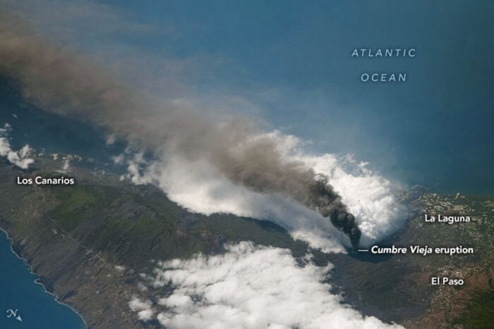
Cumbre Vieja Ash Plumes
Since the current eruption began, the volcano has ejected a rising column of superheated ash and gases into the air directly above. Ash has blanketed much of La Palma – although it has not accumulated enough to cause damage to buildings, pipes and drains have been clogged, and it has forced the island’s airport to close on two separate occasions.

The volcano has not been powerful enough to propel ash into the stratosphere, being limited to a maximum height of 3.3 miles (5.3 km) high, where it has been capped by a warmer, drier layer of air. Therefore, the ash clouds have flattened out and have spread outward from the island.
A large plume of ash and smoke has traveled more than 50 miles (80 km) to the south of the volcano, carried by the wind. However, the ash has not had significant effects on the other islands in the Canaries archipelago.
Due to the plume being capped at just over 3 miles above sea level, the volcanic emissions will not have much of an effect on the climate and weather of the surrounding area.
Cumbre Vieja Sulfur Dioxide Emissions
Large amounts of sulfur dioxide, as much as 17,000 tons per day, have been emitted from the volcano during the eruption. Due to the prevailing wind direction, plumes of the gas have traveled in different directions, even across the Atlantic to the Caribbean, although this particular plume has now dissipated.
As of 12th October, sulfur dioxide is being blown in the opposite direction, across the northern side of the Sahara Desert. However, the concentrations are currently not large enough to pose a threat to people living near the volcano, or in areas where the plumes are being blown to.
Cumbre Vieja Earthquakes Swarms
Frequent earthquake swarms have been associated with the eruption, beginning on September 10th, nine days before the eruption, and ongoing throughout the event.
Although many of the earthquakes are too slight to be felt by most people, a large number have exceeded 3 on the Richter Scale, including the 4.2-magnitude quake that occurred a few hours before the volcano erupted.
The earthquakes have not reduced in frequency and strength, with a 4.6-magnitude quake – the largest yet – being recorded on the 16th October. This indicates that the eruption is not close to ending, and could continue for a few more months.
Could La Palma Collapse?
A highly-speculative scientific paper, published in 2001, puts forward some geological evidence suggesting that the western side of La Palma may collapse into the sea if the Cumbre Vieja volcano erupts in the future, producing a mega-tsunami. The paper is only speculative, and does not state that this is a definite consequence of an eruption, but an unlikely outcome.
As a result, when the volcano started to erupt, news of the paper spread around on social media, with some people concerned about the event. Many experts in the field of landslide mechanics, including Professor Dave Petley, have explained that such a collapse, and a mega-tsunami, are both incredibly unlikely.
Flank collapses are always a concern when eruptions occur on towering volcanic eruptions, but they are very rare. Furthermore, a 2015 scientific study used realistic and state-of-the-art modeling techniques to conclude that if the island did collapse, the event would result in a tsunami only six feet high reaching western coastlines of the Atlantic Ocean, including the eastern seaboard of the United States.
The Volcanology Institute of the Canary Islands also states that it would take an incredibly powerful earthquake, along with a much more explosive volcanic eruption than the current event, to cause a large-scale collapse of the island.
References
Andrews, R. G. (2021, September 20). Canary Islands volcano roars to life for first time in 50 years. National Geographic. https://www.nationalgeographic.com/science/article/canary-islands-volcano-roars-to-life-for-first-time-in-50-years
Carlowicz, M. (2021, October 9). Eruption continues at la Palma. NASA Earth Observatory. https://earthobservatory.nasa.gov/images/148946/eruption-continues-at-la-palma
La Palma volcano eruption update: Eruption continues with high effusion rates. (2021, October 13). VolcanoDiscovery. https://www.volcanodiscovery.com/la-palma/news/144227/La-Palma-volcano-eruption-update-eruption-continues-with-high-effusion-rates.html
La Palma volcano update: Largest so far quake at magnitude 4.6 this morning. (2021, October 16). VolcanoDiscovery. https://www.volcanodiscovery.com/la-palma/news/144467/La-Palma-volcano-update-Largest-so-far-quake-at-magnitude-46-this-morning.html
Petley, D. (2017, July 31). Understanding the la Palma mega-landslide hypothesis: Part 2. The Landslide Blog. https://blogs.agu.org/landslideblog/2017/07/14/la-palma-part-2/
Pultarova, T. (2021, October 12). Satellites capture reinvigorated la Palma volcanic eruption. Space.com. https://www.space.com/satellites-capture-revitalized-la-palma-volcano-eruption
Voiland, A. (2021, October 5). Ash and cloud rings over la Palma. NASA Earth Observatory. https://earthobservatory.nasa.gov/images/148924/ash-and-cloud-rings-over-la-palma