
Geomorphology

Geology Quick Facts for Each U.S. State
Listed here are the official state rock, gemstone, mineral, and fossil for each U.S. State.

Geography Facts About the Rocky Mountains
The Rocky Mountains form the longest mountain range in North America. Here are some geography facts about this mountain range.

Plateaus in Geography
A plateau is a flat section of land that is sharply raised in contrast to the surrounding landscape on at least one side.

North American Continental Divide
The North American Continental Divide separates the watersheds that flow into the Pacific Ocean and those that flow into the Gulf of Mexico and the Atlantic, Caribbean, and Arctic Oceans.

The Earth’s Only Active Volcano Known to Emit Natrocarbonatites
Only one active volcano in the world is known to emit natrocarbonatite.

How Oxbow Lakes Form
An oxbow lake is a uniquely shaped lake resulting from the path of a meandering river.

The United States Ranks Third for Historically Active Volcanoes
The United States ranks behind Indonesia and Japan for historically active volcanoes based on written records.

Mount Etna Erupts
Mount Etna's latest eruptions occurred on February 16 and again on February 18, 2021.

The Continent of Africa Might Eventually Split
Rifts could split Africa into pieces and create a new ocean that would form in the rift valleys.

World’s Largest Active Geyser
Located in the Norris Geyser Basin in Yellowstone National Park is Steamboat Geyser, the world's largest active geyser.

What is a Mountain?
While it is widely assumed that a mountain is higher than a hill, there is no universally accepted definition of a mountain.

What are Barrancas?
One place to find barrancas is at the lower elevations of La Malinche volcano in central Mexico.

Linking Geological Events to Aboriginal Oral Tradition and Stories
Recent findings about the existence of human civilization dating back 50,000 years suggests major geological events have been described in Aboriginal oral tradition and stories.

Earth’s Largest Shield Volcano
Scientists have discovered the Earth's largest volcano using bathymetric and gravity mapping.


Physical and Chemical Weathering of Rocks
Weathering is the breaking down of rock material by physical or chemical processes.

Australia’s Yarrabubba is the Oldest Impact Crater on Earth
Recently published research indicates that the Yarrabubba impact structure in Australia may be the world's oldest.

This Detailed Map Shows 119 Years of Earthquakes
The USGS has released a highly detailed and updated map of seismicity from 1900 to 2018.

The World’s Highest Concentration of Hoodoos
Hoodoos are tall, thin rock spires that occur all around the world.

Seven Summits: The Tallest Mountain on Each Continent
Listed here are the tallest mountains based on summit elevation for each of the seven continents.
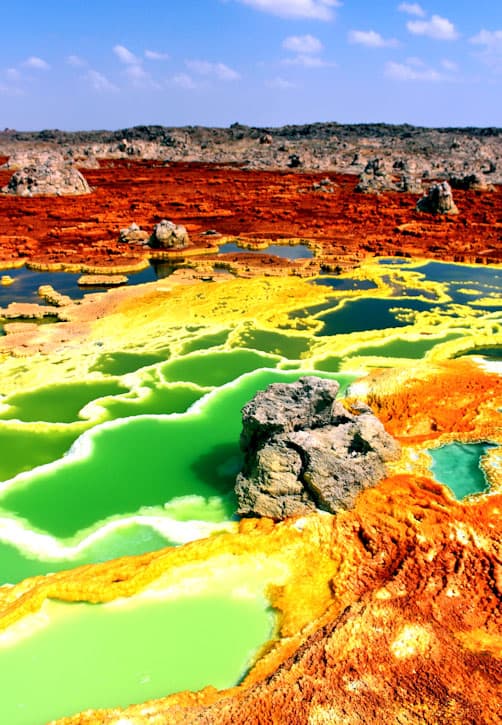
A Place on Earth Where No Life Exists
Researchers recently discovered at least one location on Earth that lacks any discernible life forms.

Japan’s Highest Mountain
At 3,776 meters (12,389 feet) tall, Mount Fuji is Japan's highest mountain.

The Arctic Permafrost is Thawing and It’s Causing Thousands of Landslides
Using Banks Island, Canada as a study area, researchers analyzed trends in permafrost thaw and associated landslides.

Using Dark Fiber to Measure Seismic Activity
Researchers wanted to test if unlit fiber cable could be used to collect measurements of seismic activity to fill in spatial gaps in the data.

What’s the Tallest Point in Niger?
Located in northern Niger, Mont Idoukal-n-Taghes rises to a summit height of 2,022 meters (6,634 feet) above sea level.

The Importance of Geomorphology for Physical Geographers
Geomorphology is the study of Earth’s landforms created by mostly physical processes.