
A plateau is a flat section of land that is sharply raised in contrast to the surrounding landscape on at least one side. Plateaus are also known as high plains or tablelands.
Plateaus can be formed through either volcanic or erosional processes: upwelling of volcanic magma, extrusion of lava, or erosion by water and glaciers. Plateaus areas that have been severely eroded are known as dissected plateaus.
Across the geography of the United States, there are several prominent plateaus.
Colorado Plateau

The Colorado Plateau covers 336,700 km2 (130,000 mi2) in the Four Corners region of the southwestern United States: western Colorado, northwestern New Mexico, southeastern and eastern Utah, and northern Arizona. The Colorado Plateau is the largest plateau in North America.
Mostly high desert, the Colorado Plateau also has some scattered forests.
How was the Colorado Plateau Created?
Between 30 – 70 million years ago, plate tectonics lifted the region, creating the high and relatively flat Colorado Plateau.

Kaibab Plateau, Arizona
The Kaibab Plateau is located almost entirely in Coconino County, Arizona with a small section that extends north into Kane County, Utah. The plateau is part of the larger Colorado Plateau.

Limestone Plateau West of Custer, South Dakota
The Limestone Plateau along the South Dakota-Wyoming border west of Custer, SD. Numerous headwater springs occur along the eastern edge of the Limestone Plateau. Large outcrops of the Madison Limestone and Minnelusa Formation form the plateau.

Missouri Plateau
The Missouri Plateau, or Coteau du Missouri, is a plateau found where the Rocky Mountains meet the Great Plains of central-northwest United States. A gentle sloping plateau, the Missouri Plateau contains unglaciated areas that are 300 to 400 feet higher than the Drift Prairie.

The Missouri Plateau, with elevations between 2,000 and 3,000 feet is the highest land in the state of Missouri.
Meseta de Canquel, Argentina
Meseta de Canquel is a volcanic plateau in Argentina. Meseta means “plateau” in Spanish. This Landsat 8 image shows the plateau. The darkest colors are volcanic rocks from the Oligocene-Miocene and they are 25-30 million years old.

Largest Plateau in the World
The Tibetan Plateau is the largest plateau in the world, occupying an area of 2,500,000 km2 (970,000 mi2). The Tibetan Plateau is also the highest plateau in the world with an average elevation of 4,500 meters (14,800 feet),
Because of its high elevation, the Tibetan Plateau is nicknamed the “roof of the world.” The Tibetan Plateau was formed, and is still being formed, by the collision of the Indo-Australian and Eurasian tectonic plates.
The Tibetan Plateau gives rises to most of Asia’s major rivers. The plateau is also home to many salt and freshwater lakes. Nam Co, with an elevation of 4,718 m (15,479 ft), is one of the world’s highest altitude saltwater lakes.

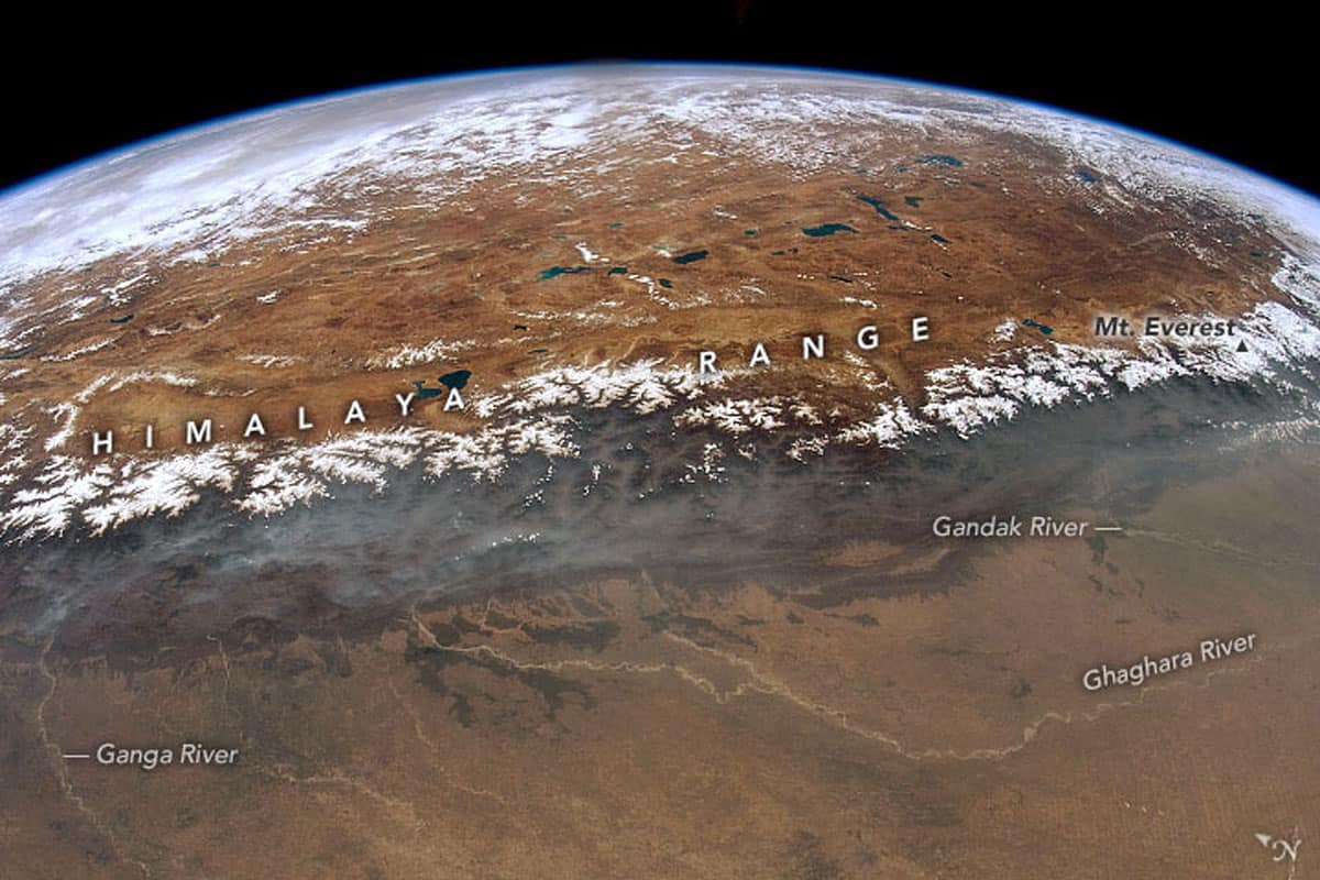
At the southern rim of the plateau lie the Himalayas. Onboard the International Space Station, astronaut Don Pettit captured a view of a 1000 kilometer (600 mile) stretch of the snow-capped peaks of the Himalayas. The Tibetan Plateau, with its lakes and mountains, can be seen beyond the Himalayas while the Ganges/Ganga Plains is in the foreground.
What is a Mesa?
A mesa (Spanish for table) is a plateau that has been carved by erosion into smaller units. Mesas are small, high plateaus with a flat top and steep sides that have been isolated by the widening of canyons. Mesas are more commonly found in the drier southwestern states of Colorado, New Mexico, Utah, and Arizona.

Butte
When mesas further erode, what results are buttes. Buttes are even more isolated with a small, hard-capped top layer that slows the formation from erosion of its lower layers.
Dellenbaugh Butte in Utah along the Green River is an example of butte. Also known as the Anvil, or Inkwell Butte, the butte is mostly composed of the Summerville Formation, and has thin layers of shale, siltstone, and sandstone.

Pillars
The smallest formation after a butte is the pillar. As erosion continues to whittle away at a plateau formation, what is left behind is a tall narrow pinnacle, or pillar, atop a wider base.
Chimney Rock in western Nebraska is one notable example of a pillar with an elevation of 4,228 feet (1,289 meters). Found along the historical Oregon Trail, Chimney Rock was designated a National Historic Site on August 9, 1956.

Hoodoos
Bryce Canyon is notable for its hoodoos, distinctively shaped pillars found mostly in hot, dry deserts.
More: The World’s Highest Concentration of Hoodoos and video: Otherworldly Hoodoos.
