
This landlocked country in West Africa was named after the Niger River. About 65 percent of Niger is covered by the Sahara Desert landscape with large areas of shifting sand dunes and broad gravel and stony plains.
The highest point in Niger is located in the Bagzane Plateau. The Bagzane Plateau is situated within the Aïr Mountains, a series of massifs and plateaus that stretch across northeastern Niger.
The Aïr Mountains are primarily composed of Precambrian crystalline rocks, which date back to over 600 million years ago. In contrast, the Bagzane Plateau is characterized by its sandstone formations, making it a unique geological feature within the broader mountain range.
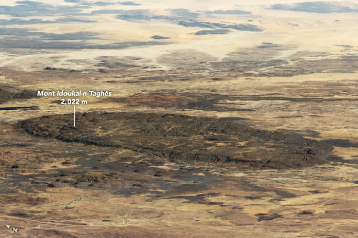
Located in northern Niger, Mont Idoukal-n-Taghes rises to a summit height of 2,022 meters (6,634 feet) above sea level. The mountain is part of the Aïr Mountains which form an ecological island of Sahel climate, providing seasonal rains.

Formation of Mont Idoukal-n-Taghes
The formation of Mont Idoukal-n-Taghes is closely linked to the tectonic activity that gave rise to the Aïr Mountains.
The uplifting of the Earth’s crust in this region led to the creation of the mountain range, and as a result, the towering peak of Mont Idoukal-n-Taghes. Over time, erosion sculpted the mountain’s striking landscape, leaving behind steep cliffs, deep gorges, and a series of plateaus that surround the peak.
An ecological island
Due to its elevation, Mont Idoukal-n-Taghes experiences a somewhat distinct microclimate compared to the surrounding lowlands.
The mountain receives more rainfall and has cooler temperatures, which allows for a greater variety of plant and animal life.
This unique microclimate contributes to the diverse range of ecosystems found in the vicinity of Mont Idoukal-n-Taghes, further emphasizing the importance of this geographic landmark.
An extensive range of habitats found in the Aïr Mountains —such as sand dunes, rocky deserts, valley cliffs, canyons, plateaus, and waterholes—support 40 mammal species, 165 bird species, 18 reptile species, and 1 amphibian species. The region offers ideal conditions for three desert antelope species: the Dorcas gazelle, the Slender-horned gazelle, and the critically endangered Addax.
Part of the largest protected area in Africa
These mountains are part of the largest protected area in Africa. The Aïr and Ténéré Natural Reserve, designated as a UNESCO World Heritage site in 1991, is home to three threatened antelope species, as well as important populations of the fennec fox, Rüppell’s fox, and cheetah.

More:
- The Tallest Point in Niger, Earth Observatory, NASA