
Dunes are a mound or ridge-shaped landform that are typically comprised of sand, although they are occasionally made of another type of sediment. It is often the result of wind and water processes that have allowed sand to accumulate in a specific location over a long period of time.
There are five basic types of sand dunes whose formations is affected by wind, vegetation, and the size of the sand grains.
Dunes often occur in expansive clusters or dune fields, some exceeding hundreds of square miles in area. Their formation requires a certain type of surrounding landscape and environmental conditions, hence why they are often found in coastal environments.
However, dune fields can also occur inland, particularly where rain is absent for much of the year.
Where are Sand Dunes Located in the United States?
Within the United States, dune fields are quite rare, and are most commonly found in southwestern desert areas of the country. These include the Great Sand Dunes in southern Colorado, and the Mesquite Flat Sand Dunes located in Death Valley, eastern California. Both of these locations are considered to be some of the U.S.’s largest and most striking dune fields.
Many other dune fields are also situated in parts of Nevada, Arizona, Utah, New Mexico and Texas, areas which receive little precipitation, and are often subject to long dry seasons. Some of the USA’s prairie-type territory is also home to dunes, such as the vast Nebraska Sandhills.

Sand Dunes are also found along coastal areas of the United States, in particular along the coast of Oregon between Barview and Florence, parts of the Great Lakes, and scattered along sections of the east coast.
How are Sand Dunes Created?
Typically, both wind and water processes act together to create sand dunes, whether they are located in the desert or along the coast. The wind picks up sand particles, transports them over a distance, and deposits them in a depression, or against a large structure such as a hillslope or mountain range. This is particularly common in dryland zones, where a lack of surface moisture means that many sand particles can be easily lofted into the air by the wind.

Water processes work in a rather similar way, but involving surface flow, which transports sand particles from a source and deposits them in a depression or against a slope. On the coast, frequent strong winds and strong wave and tidal action work together to build dune fields.
Where are the Tallest Sand Dunes in the United States?
The tallest dunes in the United States are located in the Great Sand Dunes National Park in Colorado, many of which peak over 600 feet above the surrounding valley floor. Star Dune is the tallest, the crest of which reaches a height of 750 feet.
With an area of some 30 square miles, the entire dune field is rather expansive. The history behind the formation of these dunes is a great example of how both wind and water processes work together to produce a vast dune field.

The dunes have built up on the western side of the Sangre de Cristos Mountains, and are located in the San Luis Valley, a large basin flanked by two mountain ranges. The basin is filled with sedimentary deposits which have been washed into the basin during intense rainfall and have since dried out. The prevailing westerly winds then blow the particles eastward, depositing them against the slopes of the Sangre de Cristos range.
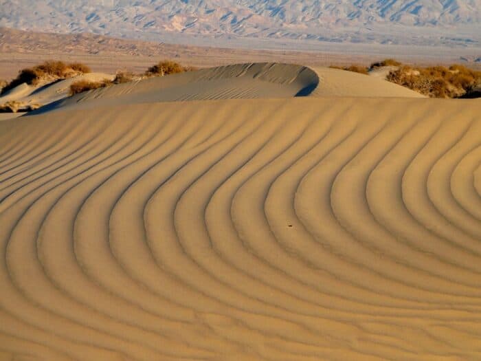
Sand Dunes in Death Valley
Several dune fields are located in Death Valley in eastern California. These dunes are also placed in a large depression; however, this basin is much deeper and is surrounded by giant mountain ranges that exceed 6,000 feet in elevation.

Large amounts of sediment are eroded and washed down from the mountains during rare and intense rainfall events, which are then deposited in the vast basin below. For example, in the case of the Mesquite dunes, the eroding Grapevine Mountains to the north provide an ample source of sand, which is blown into position by the prevailing westerly wind.
The sand builds up against the mountains, thus forming into an incredibly large dune field. Although the largest of the dunes reaches a height of 185 feet above the surrounding basin, it is spread out over a massive area totalling 5,000 square miles.
Largest Sand Dune System in the Western Hemisphere
Spread out over an area of 20,000 square miles, the Nebraska Sandhills (also written as the Nebraska Sand Hills) is the largest dune system located not only in the USA, but throughout the entirety of the Western Hemisphere. It is covered in thick prairie grass, which plays a large part in maintaining the stability of the dune field.

Located in north-central Nebraska, the Nebraska Sandhills owes its existence to glacial meltwater during the end of the last Ice Age; as the ice sheets receded, meltwater from the nearby Rocky Mountains brought huge amounts of sand and silt to the region. Wind activity played its role in creating the dunes, which were then covered in grass, locking them into shape.
Oregon Dunes
Stretching for around 50 miles in length, from Barview in the south through to Florence in the north, the Oregon Dunes are the longest expanse of coastal dunes in North America, and one of the longest in the world.
Unlike the dunes of the southwestern USA, these dunes are placed in a temperate climate zone that receives large rainfall rates. The nearby Coast Mountain Range, which uplifted as recently as 12 million years ago, supplies a great deal of constantly-eroding sediment, some of which is deposited onto the shore.
Summer winds and strong gusts from winter storms pick up sand particles and deposit them along the coast. In addition, strong waves and tidal currents dredge the sand from the nearby shallow seabed and place it onto the shore, where the wind drifts the sand into dunes.
Sleeping Bear Dunes
Large sections along the eastern side of Lake Michigan are also made up of expansive sand fields. These include the Sleeping Bear Dunes, a dune field that is perched up above a large bluff that borders the lake. The crest of the tallest dune reaches a height that exceeds 300 feet above the lake surface.

Interestingly, this dune field was mostly formed from glacial processes. During the last glacial maximum, giant ice sheets covered the area, which ground the rock beneath into sand and other soft sediment. When the ice retreated from the area around 12,000 years ago, it left behind large dune fields. More sand grains are also blown up onto the Sleeping Bear dune field from the shoreline along the bluffs below, which allows additional sand to pile up high above the lake.
Largest Active Sand Dunes in the Arctic
The largest active sand dunes in the Arctic are the Great Kobuk Sand Dunes in Alaska. These dunes rise out of the forest along the southern bank of the Kobuk River and are a relic of the last Ice Age. Over thousands of years, vegetation has slowly reclaimed all but 16,000 acres of the original 200,000 sand dunes that were formed.

References
Death Valley Sand Dunes. (n.d.). NPS.gov (U.S. National Park Service). https://www.nps.gov/deva/learn/nature/sand-dunes.htm
Geology: Great Sand Dunes (n.d.). U.S. National Park Service. https://www.nps.gov/grsa/learn/nature/sanddunes.htm
Geology of the Oregon Dunes. (n.d.). US Forest Service. https://www.fs.usda.gov/detailfull/siuslaw/learning/nature-science/?cid=fsbdev7_007155
Great Kobuk sand dunes. (n.d.). U.S. National Park Service. https://www.nps.gov/kova/learn/nature/great-kobuk-sand-dunes.htm
Mesquite flat sand dunes. (n.d.). U.S. National Park Service. https://www.nps.gov/places/mesquite-flat-sand-dunes.htm
Sleeping Bear Dunes national Lakeshore. (2021, August 18). U.S. National Park Service. https://www.nps.gov/slbe/index.htm
Where to find the Western Hemisphere’s largest sand dunes. (2020, October 16). National Geographic. https://www.nationalgeographic.com/travel/article/sandhills-largest-sand-dunes-western-hemisphere