
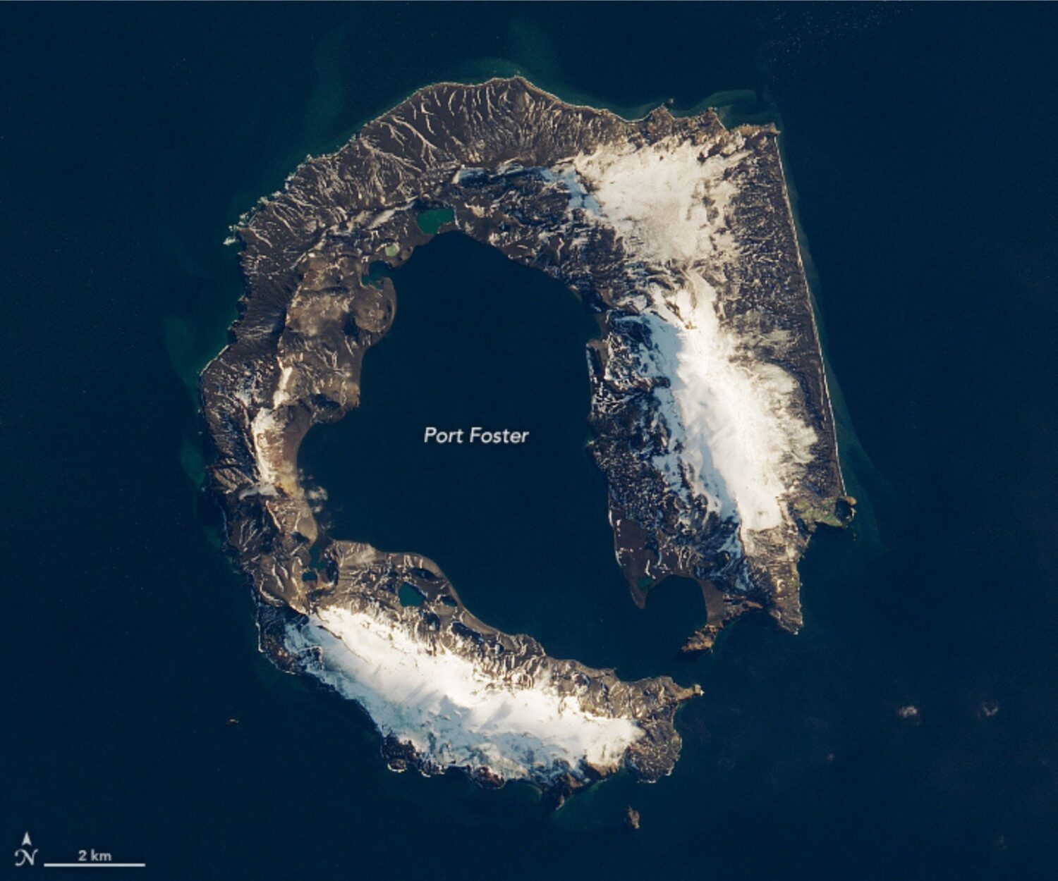
Deception Island, near the Antarctic Peninsula, is unique because it allows ships to enter the middle of an active volcano.
The island earned its name from explorer Nathaniel Palmer in 1820 thanks to its horseshoe shape. From one angle, the island gives the illusions that it is solid all the way around. From another angle, the flooded interior of this caldera becomes apparent.
The caldera was created when an eruption about 4,000 years ago caused a volcano in the South Ocean to collapse. The resulting caldera measures about five to six miles (eight to ten kilometers) in a diameter.

Deception Island, located in the South Shetland Islands, is still an active volcano. The island has erupted more than twenty times since the 19th century. The most recent eruptions occurred in 1967, 1969, and 1970.
Deception Island and Mount Erebus are the only two active volcanoes in Antarctica.

Inside the island lies Port Foster where ships can dock. This makes Deception Island one of the only places in the world where ships can sail directly into the middle of an active volcano.
The island was used as a whaling station up until the early 1900s and the ruins of Hektor Station still remain on the island after closing in 1931.
The harbor is a popular destination with tourists, with about 15,000 visitors a year to Deception Island according to the International Association of Antarctica Tour Operators (IAATO). Visitors enter the sea lagoon that is Port Foster via a small opening between cliffs called Neptune’s Bellows.
The lack of glaciers in the interior waters of the island as well as the chinstrap penguin population are two of the key draws for tourism on the island. Deception Island hosts the world’s largest population of chinstrap penguins with over 400,000 birds that inhabit the outside perimeter of the rocky island. Weddell, fur, crabeater, leopard, and southern elephant seals use the island as a resting point.
The island is also home to two active research stations. One operator by the Instituto Antartico Argentino and the other by Spanish National Research Council. Both are only operated during the austral summers.

References
Geyer, A., Álvarez-Valero, A. M., Gisbert, G., Aulinas, M., Hernández-Barreña, D., Lobo, A., & Martí, J. (2019). Deciphering the evolution of Deception Island’s magmatic system. Scientific Reports, 9(1), 373. https://doi.org/10.1038/s41598-018-36188-4
Patel, K. (2020, January 18). The island shaped like a horseshoe. NASA Earth Observatory. https://earthobservatory.nasa.gov/images/146164/the-island-shaped-like-a-horseshoe