
Environmental Geography
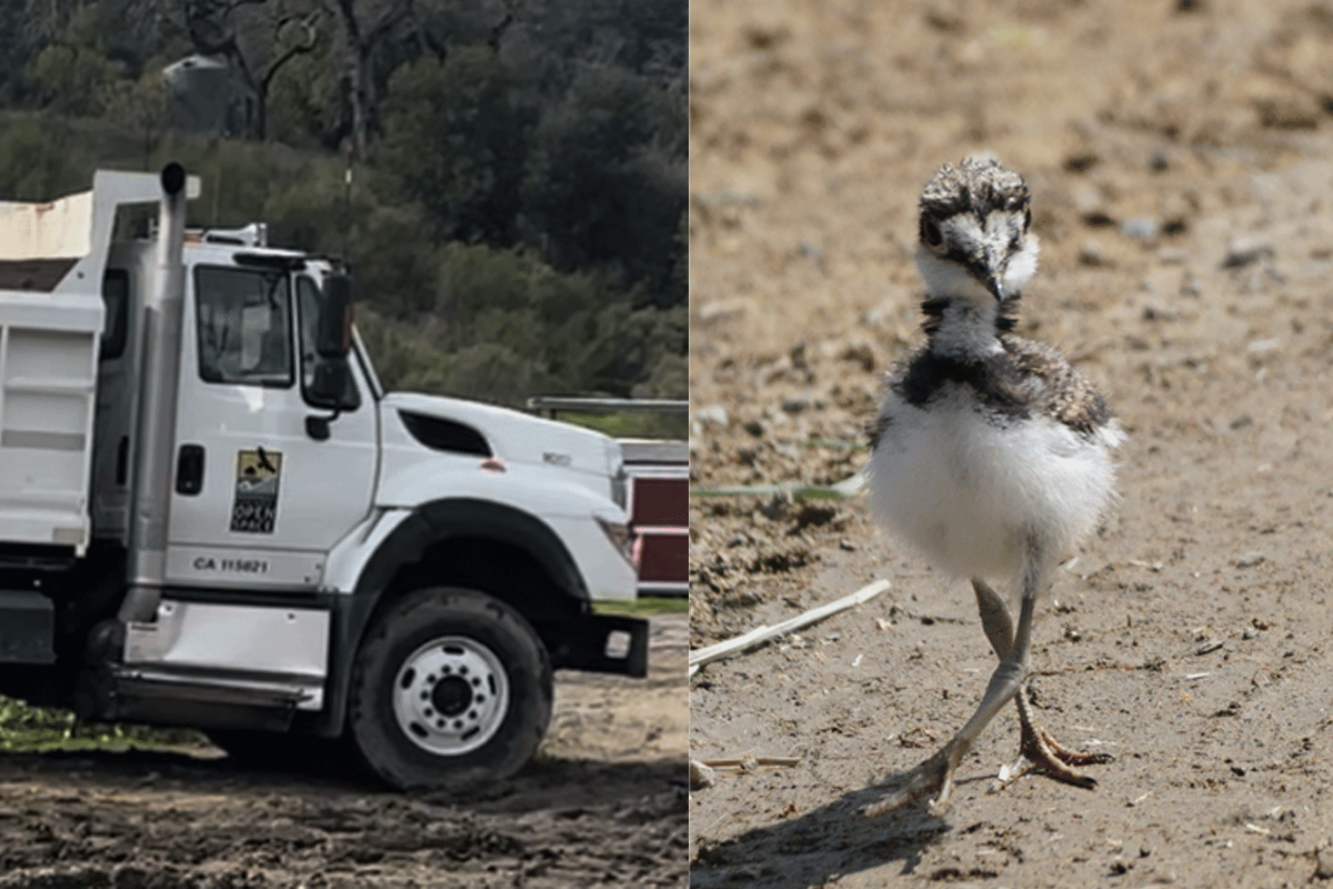
Midpen Open Space and the Harm of Repeat Disturbance
At Bear Creek Redwoods Open Space Preserve, repeated nesting season projects by Midpeninsula Regional Open Space District are altering habitat used by migratory birds.

Increased Light Pollution in the Arctic
Satellite data reveals growing nighttime light levels across the Arctic, linked to expanding oil, gas, shipping, and infrastructure activity.

Tracking Mercury With Dragonflies
Published research mapped mercury levels in dragonfly larvae from 73 U.S. parks, revealing how the metal accumulates in the environment.

A Guide to the Geography of U.S. National Parks
Find out the answers to geography trivia questions and more in this article about the geography of U.S. National Parks.

The Role of Secondary Forests in Reducing Atmospheric Carbon
Secondary forests play an important role in carbon capture strategies aimed towards reducing atmospheric carbon.

Study: More U.S. Homes Burn in Grassland and Shrubland Fires than Forest Wildfires
A new study in Science reports that in the United States, grassland and shrubland fires tend to be more extensive and burn more houses than forest fires.
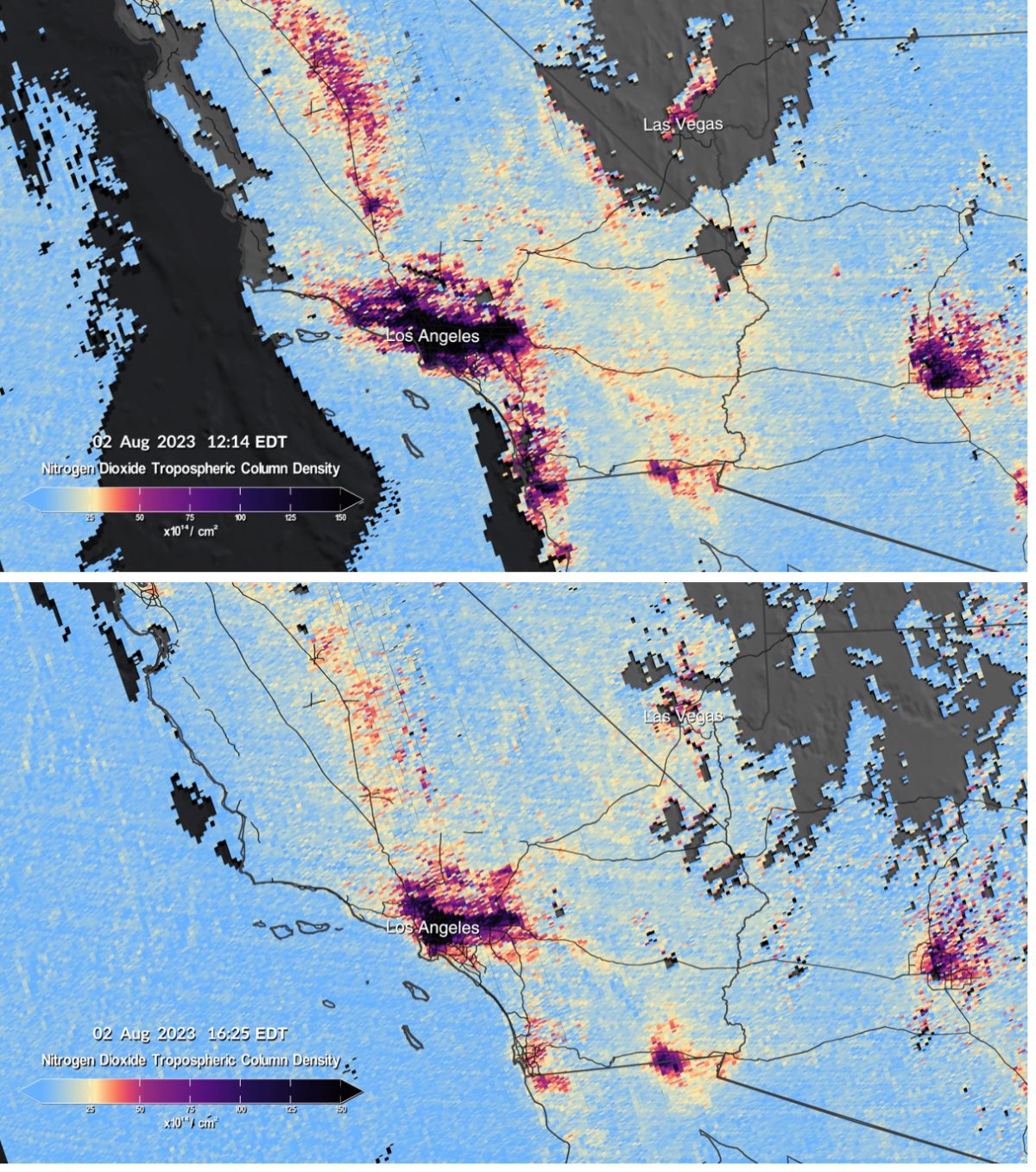
Mapping Air Pollution in the United States
NEMO and TEMPO are two scientific endeavors aimed at producing hourly air pollution maps of the United States.

Rising Sea Levels and Human Migration
Researchers predict that by 2100 between 17 to 72 million people will migrate as a result of coastal land loss due to sea level rise.

World’s Largest Freshwater Wind Farm
The world's largest freshwater wind farm is the 89-turbine installation in Lake Ijssel located south of the Wadden Sea in the Netherlands.

Causes of Wildfires in the United States
Every year, thousands of wildfires rage across the United States, consuming millions of acres.

Wildfire Smoke From Canada is Affecting Parts of the United States
Smoke from the June 2023 Canadian wildfires is affecting the Midwest and northern regions of the United States.

Earth at Night
Nighttime lighting is when the effect of humans on the environment is especially pronounced.

How Ships Create Clouds Over the Oceans
Ships can create a trail of clouds as they travel over the world's oceans.

Early Wildfires in New Mexico
Wildfires in New Mexico are are starting earlier each year due to warmer and drier conditions.

Study: Afforestation Can Lead to More Cloud Cover
Increased forest cover can lead to more low lying clouds which helps to cool the Earth.

Geography Facts About Yellowstone National Park
Learn some quick and fun geography facts about Yellowstone National Park.

Pyrocene: the Age of Fire?
Climate change and human activities are creating record wildfire seasons.

Review | Extinctions: Living and Dying in the Margin of Error
This book sets out, in some nine chapters, both the ‘turbulent’ journey of that one species living 3.7 billion years ago to the 8.7 million today and the human activity threatening that biodiversity.

2021 Wildfires in the U.S. and Canada
Climate change is causing wildfires to burn longer and more frequently in some northern latitudes.

Tracking Plastic in the Air
Approximately 1,100 tons of microplastics are thought to be floating in the air above the Western United States

80% of Plastic in the Ocean Comes From 1,656 Rivers
A team of researchers analyzed where geographically rivers are the biggest sources of plastic pollution entering the ocean.

Climate Change is Increasing Post-Wildfire Landslides in Southern California
A recently published study has forecasted that climate change is driving increased wildfire and landslide risk in Southern California.

Geography Facts About Death Valley
Learn some interesting geography facts in this article about Death Valley.

A View of 2020 from Space
EOS Data Analytics, an AI-powered satellite analytics platform, shares satellite imagery that highlights some of the environmental tragedies that occurred in 2020 — California and Colorado fires, Hurricane Laura, Kamchatka spill, Norilsk oil spill, and the Calving on the Brunt Ice Shelf.

Three of Colorado’s Wildfires are the Largest in Recorded History for the State
Widespread drought and heat waves are helping to fuel a record-breaking fire season in Colorado.

Carbon Monoxide from the California Wildfires
As wildfires burn in California, carbon monoxide is rising high up into the atmosphere where a NASA satellite is capturing readings.