

EOS Data Analytics, an AI-powered satellite analytics platform, shares satellite imagery that highlights some of the environmental tragedies that occurred in 2020 — California and Colorado fires, Hurricane Laura, Kamchatka spill, Norilsk oil spill, and the Calving on the Brunt Ice Shelf.
2020 has been packed with surprises and many are ready for the year to come to a close. A lot has happened in 2020 especially with the spread of the novel coronavirus fueling a pandemic. 2020 has also brought natural disasters in the form of hurricanes, flooding, fires, and volcanic eruptions. We have also seen global protests, locust swarms, and more. With the coronavirus vaccine rolling out, many are hoping that 2021 brings a healthier and brighter future.
Today, we’ll shine a light on the Thanks to advancements in technology, we can at least keep an eye on these events and make informed decisions. With modern satellite technology, organizations, regulators, and even individuals can access space imagery of the entire global village in just a few clicks.
Below is a brief rundown of the most memorable and large-scale events that we watched from space in 2020.
1. California and Colorado fires.
The California Department of Forestry and Fire Protection reported that 9,279 fires had burned over 4 million acres of land in 2020 alone. Sadly, thirty-one people have died as a result of these forest fires.
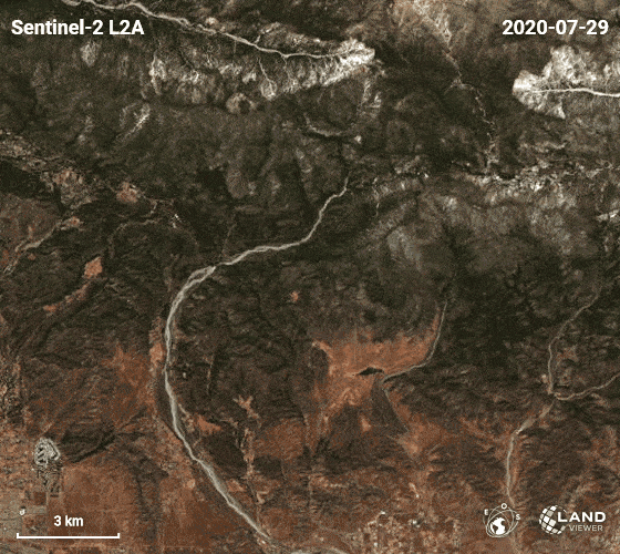
Since May, wildfires have also razed over 624,000 acres in Colorado, killing at least two people and causing at least $195m worth of damage. But with access to accurate satellite data on forest fires, responsible authorities can better determine the scale of incidents, respond more quickly, accurately, and correctly.
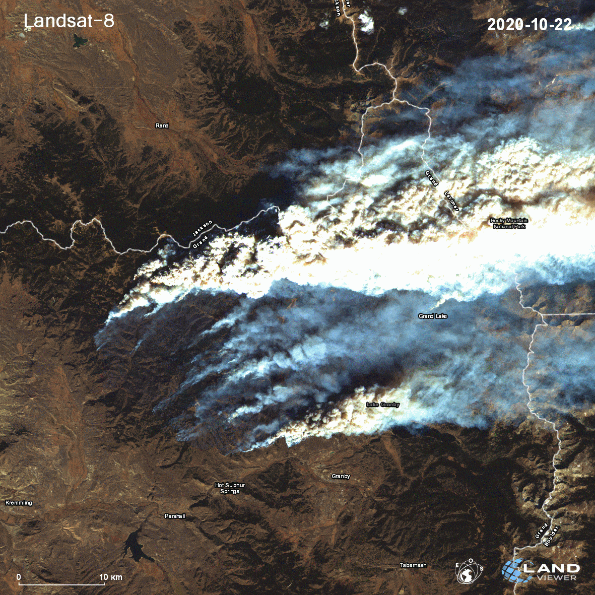
According to the US Forest Service, fire seasons are now 78 days longer than they were in the 1970s. Experts and scientists cite global warming as the main culprit for this trend.
The California National Guard made some of their most daring and biggest rescues this year as a result of the fires. Regular people chipped in to do their part as well – residents of the Santa Cruz mountains, including a Stanford professor, came together to evacuate farms, saving horses, dogs, cats and other animals.
2. Hurricane Laura.
In August 2020, Laura became the tenth hurricane with wind speed over 240 km / h to hit the United States, making landfall on the Gulf Coast. This destructive Category Four hurricane was one of the strongest to hit Louisiana.
However, it didn’t come as a surprise, thanks to the use of satellite images – like the ones provided by NASA’s GOES satellite. It allows researchers to observe hurricanes as they evolve, making it easier to track and predict their impact today.
The hurricane didn’t only bring devastation: in one heartwarming story, a woman by the name of Robin Baudin shared how she survived the hurricane along with her daughter and two friends. When Hurricane Laura hit her town, the family sheltered in the bathroom, covering themselves with pillows and blankets. Their roof came off, but thankfully everyone managed to get to safety by waiting out the storm at a neighbor’s house.
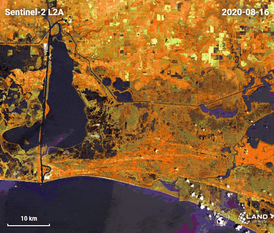
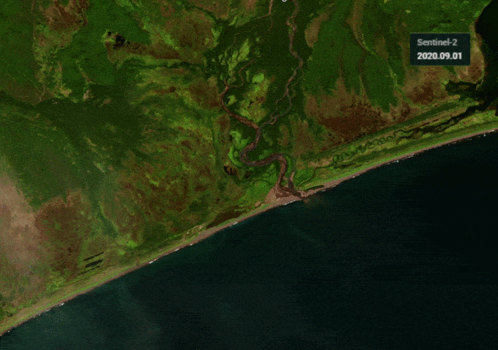
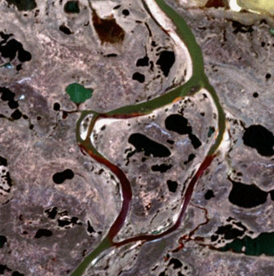
3. Kamchatka spill.
Right along a 25 mile stretch of coast in Russia’s Far East Kamchatka region, thousands of sea creatures turned up dead due to a suspected toxic leak. The contamination also affected a UNESCO World Natural Heritage Site, and the fishing and surfing community — several people were also reported to have fallen sick.
The environmental organization Greenpeace has been involved in clean-up efforts, assisted by satellite images taken between September 1 and 9. The images actually show the point at which the river in Kamchatka began pouring toxins into the ocean, making it easy to identify the source of the leak.
That same month, the seawater in the area was found to contain oil components, including phenol. This resulted in mass death of marine life (95% have died) at depths from 10 to 15 meters.
We shouldn’t forget that we learned about this ecological disaster from messages on social networks and independent media. Major Russian bloggers and activists like Yuri Dud pushed the topic into the mainstream, and thanks to them this disaster did not go unnoticed. Locals reported vomiting and fever after going into the water, including surfers like Anton Morozov, who survived the ordeal and began helping bring awareness to the spill.
4. Norilsk oil spill.
In May, Russia declared a state of an environmental emergency in the aftermath of the Norilsk Oil spill, where around 21,000 tonnes of diesel leaked into the Arctic. Given its location, clean-up efforts were fraught with difficulties.
And because of the remote position of the disaster, experts had to turn to satellite data to quickly and accurately assess its impact and scale. The satellite images were invaluable in intensifying prevention measures and salvaging the maritime ecosystem by pinpointing where clean-up efforts should be focused.
To date, environmentalists, along with backing from Russian authorities and help from the US, have been leading clean-up efforts. The Russian President declared a state of emergency to get the leak contained and prioritise disaster management.
5. Calving on the Brunt Ice Shelf.
The second crack on the Brunt Ice Shelf, which houses the Halley Research Station in Antarctica, first appeared in October 2016. It’s been named the Halloween Crack, coming after Chasm 1, the first crack – which is currently growing at a rate of 4 kilometers per year.
Monitoring this phenomenon’s progression from above allows scientists to predict better when the cracks will merge; an iceberg of at least 1.7 thousand square kilometers is expected to break off from the glacier!

The Takeaway: Aerial imagery presents a dash of hope
From response to prevention, space-related systems help across the entire disaster cycle. In the aftermath of natural and technological catastrophes, they allow easy assessment of damage and proper evaluation of the situation on the ground.
Without satellite monitoring systems, the above catastrophes could have caused even more damage. Space-related systems have been used extensively in the aftermath of these events, working as critical support tools in emergency relief operations.
The good news is that today, anyone interested in environmental protection can access satellite data, without needing specialized equipment, university connections, or selling a kidney. From personal global positioning systems (GPS) to large scale global monitoring, satellite monitoring systems offer a growing range of useful applications.