
We have long observed the mass movements of various fauna, with well known examples such as wildebeest in the Serengeti. Now, scientists are applying big data methods that utilize new GPS and tracking capabilities and can be utilized with, among other techniques, machine learning methods to better understand how animals migrate globally.
This can reveal new and telling patterns that can aid conservation and even our own well being in new ways.
Using Geospatial Data to Analyze How Animals Interact with Their Environment
Big data approaches have begun to reveal how animals interact with their environment and with other animals in ways that were not possible before. Approaches using such massive datasets is made possible through the now increasing use of reverse-GPS technologies, helping to convert animal locations to real world locations, which primarily use acoustic signals under water and radio signals over land.[1]

Researchers also applying acoustic trilateration and more common GPS have also generated large datasets which can be combined with other techniques. Such systems are automated and have high-throughput, being both cost effective and efficient to use for different, small and large, animals in most environmental settings. Current technologies are also used to monitor multiple small animals with spatiotemporal resolution down to meter scale.
Non-Invasive tracking of Large Animals Movement with Geospatial Data
Using remote sensing data, radar and imagery enhanced using computer vision and deep learning are also enabling non-invasive methods to track large animal movements. Some other recent advancements have included combining GPS-tracked data with simulation modeling that extrapolate existing data to better inform macro patterns. Computationally models, such as agent-based models, and deep learning methods have been used to determine hidden mechanisms from high-throughput data such as reverse-GPS systems.[2]
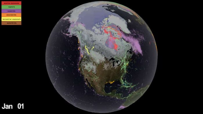
Video: Animal movements over three decades of Arctic data
The Arctic Animal Movement Archive (AAMA) is a new and increasing collection of research reporting animal movements in and near the Arctic. It currently has millions of locations for thousands of animals over a three-decade period, as recorded by hundreds of scientists and organizations. This visualization from NASA highlights this data.
Studying Animal Movement at Both the Large and Small Scale
What has been transformational for biologists and ecologists is that questions involving small-scale animal migrations and larger one could be simultaneously studied. For instance, at small scales, individuals birds being less or more shy and how they interact around other animals can be better studied. At larger scales, looking at how large schools of fish and how they avoid fishing ships can now be better understood.[3]
A Higher Resolution of Geospatial Data for Mapping Animal Behavior
Tag miniaturization has meant that the resolution of animal behaviors has also gotten much smaller at temporal scales, with interactions as short as milliseconds potentially tracked.[4] Areas where high temporal and spatial resolution have assisted researchers using big data techniques include tracking overall movement, understanding animal energy status, ontogeny, that is maturation and animal experience, personality, and cognitive capabilities.
Previously, many of these qualities were studied using captured animals. However, this was seen as limiting due to the low realism in the animal’s environment, while data tracking itself was of low resolution.
Some recent results include the study of fruit bats in Egypt, where researchers were able, for the first time, to demonstrate that bats could create detailed cognitive maps similar to how humans navigate their areas of movement.[5] The bat case study utilized more than 18 million localizations collected over 3449 bat-nights across 4 years using the ATLAS reverse-GPS system.
In another study, vulturine guineafowl (Acryllium vulturinum) studied using GPS tracking were shown to have both dominant and passive (subordinate) animals leading foraging behavior. Results showed that dominant individuals could displace subordinates animals but the excluded subordinates initiate collective movement to create their own forging groups. Dominants then abandon their foraging and followed subordinates in cases, demonstrating a sometimes complex interaction between such animal personalities.[6]
Better Geospatial Data Equals Better Wildlife Management
While researchers are benefiting by learning new patterns of animal behavior, the key benefit has also been better planning that has benefited animals. For instance, high throughput data sources have enabled rapid, nearly real-time data to be used as an early alert systems. Researchers can now provide conservation and resource managers data that inform on proximity, geofencing, movement rate, and immobility of animals.[7]
The potential now to better understand animal behaviors at various scales presents new opportunities for research, conservation, recreation, and well being from better understanding and adapting to nature. For researchers, much of these benefits is a race against time to try to understand behaviors for animals that are critically threatened and key behavioral insights could help in preserving endangered species. Additionally, how animals adapt to climate change will be a major question that interests us in coming years, particularly as we depend on a variety of animals for our own health, such as pollinating insects.
References
[1] For more on reverse-GPS techniques, see: Andrade, T.; Alves, L.N.; Cupido, L.; Santos, D. A Reverse GPS Architecture for Tracking and Location of Small Objects. In Proceedings of the 2011 International Conference on Localization and GNSS (ICL-GNSS); IEEE: Tampere, Finland, June 2011; pp. 77–80.
[2] For more on deep learning methods that also use quantitative modelling-based techniques, see: Heppenstall, A.; Crooks, A.; Malleson, N.; Manley, E.; Ge, J.; Batty, M. Future Developments in Geographical Agent‐Based Models: Challenges and Opportunities. Geogr. Anal. 2021, 53, 76–91, doi:10.1111/gean.12267.
[3] For more information about animal migrations and how they can be better studied using new tracking technologies or imagery, see: Nathan, R.; Monk, C.T.; Arlinghaus, R.; Adam, T.; Alós, J.; Assaf, M.; Baktoft, H.; Beardsworth, C.E.; Bertram, M.G.; Bijleveld, A.I.; et al. Big-Data Approaches Lead to an Increased Understanding of the Ecology of Animal Movement. Science 2022, 375, eabg1780, doi:10.1126/science.abg1780.
[4] For an example of data logging at smaller temporal scales, see: Williams, H.J.; Taylor, L.A.; Benhamou, S.; Bijleveld, A.I.; Clay, T.A.; Grissac, S.; Demšar, U.; English, H.M.; Franconi, N.; Gómez‐Laich, A.; et al. Optimizing the Use of Biologgers for Movement Ecology Research. J Anim Ecol 2020, 89, 186–206, doi:10.1111/1365-2656.13094.
[5] For more on the study looking at fruit bats forming cognitive maps, see: Toledo, S.; Shohami, D.; Schiffner, I.; Lourie, E.; Orchan, Y.; Bartan, Y.; Nathan, R. Cognitive Map–Based Navigation in Wild Bats Revealed by a New High-Throughput Tracking System. Science 2020, 369, 188–193, doi:10.1126/science.aax6904.
[6] For more on the study on forging behavior, see: Papageorgiou, D.; Farine, D.R. Shared Decision-Making Allows Subordinates to Lead When Dominants Monopolize Resources. Sci. Adv. 2020, 6, eaba5881, doi:10.1126/sciadv.aba5881.
[7] For more on tracking devices used to inform on key aspects of animal behavior, see: Wall, J.; Wittemyer, G.; Klinkenberg, B.; Douglas-Hamilton, I. Novel Opportunities for Wildlife Conservation and Research with Real-Time Monitoring. Ecological Applications 2014, 24, 593–601, doi:10.1890/13-1971.1.