
Rebecca Maxwell

Zoomorphic Maps: Imagining Maps as Animals
These zoomorphic maps were designed as propaganda tools, with each one depicting the world in a way that reflected the message the cartographer intended to convey.

Find Your Way Downstream with Streamer
Water is essential for life on the planet, and tool from the U.S. Geological Survey (USGS) makes it easy and fun ...

Ice Loss in Antarctica
In the last six years, a 750 kilometer (466 mile) strip of Antarctica has been shedding ice into the ocean at a rate of about 60 cubic km each year according to data collected from Cryosat-2.

Why Do We Blindly Follow Our GPS?
Stories abound of people blindly following GPS directions, leading to the term "death by GPS". Why do people put so much faith in digital directions?

What is the Nationality of a Baby Born on an Airplane?
It is a question that confounds the most geographically and legally astute: what is the nationality of a baby born on an airplane?

Big Data, GIS, and Bikes
The Oregon Department of Transportation (ODOT) has set a precedent for public agencies across the country with the purchase of ...

Using Google Earth to Teach Math
Real World Math uses geography lessons to teach math.

Reducing Climate Change Could Be More Difficult in the Future
A recent study has declared that limiting climate change in the future could be more difficult due to shifting conditions ...

Ensuring the Future of GIS with Geospatial Education
The U.S. government is helping to guarantee the future of GIS by investing billions of dollars in geospatial education. The ...
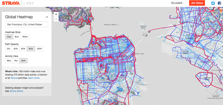
Creating a Global Heat Map from 41.5 Million Runs
Strava, a GPS running and biking application, recently released a detailed global heat map of popular routes across the globe. The map contains over 160 million activities with 375,000,000,000 data points.
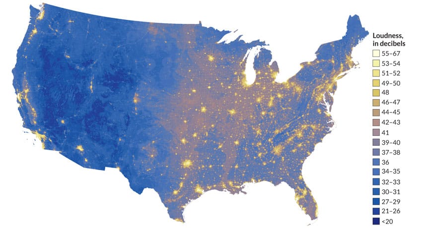
The Sound of Silence: A Noise Map of the U.S.
A map from the NPS displays the noisiest as well as the quietest places in the United States.

Using Satellite Imagery to Track the Ocean’s Acidity
The Earth’s oceans play a vital role in the health of the planet. ocean dynamics impact weather patterns, it provides ...

Maps Serve to Monitor Global Agriculture
As the world’s population grows, the amount of land available for farming is becoming a major concern. Increasing competition for ...

Using Geospatial Technologies to Save the World’s Peatlands
Rezatec has developed “Peat spotter”, a service that uses Earth Observation imagery to locate and create initial mappings of peatlands. This information is enriched with ground data collected by field agents using handheld devices.
Building Better Maps for the Visually Impaired
For those of us who can see, being able to read a map is something that we take advantage of ...

Saying “I Love You” With GPS
Aspiring Romeos around the world have been employing their GPS tools in order to give a voice to their valentines.
Paper Maps Refuse to Die in the Digital Age
In today’s era of digital maps, the use of paper maps might seem a bit antiquated. When Google Maps are ...
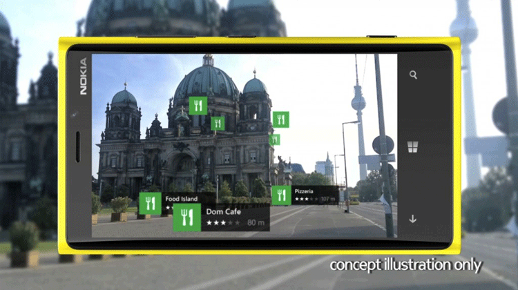
Augmented Reality and the Digital Map Revolution
Groundbreaking technology called augmented reality is affecting digital maps, changing how we find and discover the world around us.

The 25th Anniversary of the U.S. Census Bureau’s TIGER Project
It is something that many of us take for granted every day. If we need to find directions to an ...

Using GPS Data to Help Cities in Emergencies
In October of 2012, Hurricane Sandy struck the East Coast of the United States causing billions of dollars in damage. ...

Mapping Carbon in the Amazon
In order to produce the most detailed carbon maps of the Amazon, researchers turned to remote sensing, specifically satellite imagery and LiDAR.

How Mental Map Development Affects How We Perceive the Visual World Around Us
A new study is challenging the way scientists look at the brain’s visual and spatial orientation system.

New Study Discovers the Worst Drought of the Millennium Occurred in 1934
According to the National Aeronautics and Space Administration (NASA), the worst drought of the last thousand years occurred in 1934 ...

Using Drones to Create Fast Orthorectified Maps
Computer scientist Mark Pritt, along with colleagues at Lockheed Martin in Gaithersburg, Maryland, developed a new algorithm to handle thousands of images and speed up the process of creating an orthorectified map from UAV aerial imagery.

Finding Fossils with Remote Sensing
In the field of paleontology, finding fossils is often a substantial undertaking. Researchers usually have to assemble crews of up ...

New Record Extent of Sea Ice in Antarctica
The polar regions of the Earth, the Arctic Ocean and Antarctica, are of particular concern to scientists and researchers. In ...