
Water is essential for life on the planet, and tool from the U.S. Geological Survey (USGS) makes it easy and fun to trace water flow across the United States from your own computer.
Finding the path of rivers with Streamer
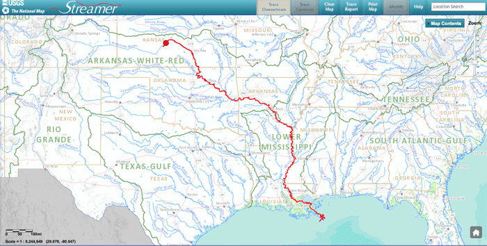
The online river mapping application is called Streamer, and with only a few clicks, users can follow major water ways from any starting point and track it to where they empty. The mapping tool also shows all other rivers and streams that flow into one with the simple click of the mouse.

What is the National Map project?
Streamer is one of the first products and services offered as part of The National Map project from the USGS.
The National Map comprises a significant portion of their mission to improve and provide topographic information for the nation. In February of 2014, the USGS announced that it would end production of their National Atlas later in the year and focus on The National Map instead. The goal behind this move is to streamline access to information, maps, and data.
As part of The National Map, Streamer has been earning praise from all over including such prestigious publications as Popular Science and Field & Stream.
Streamer is the product of digital hydrological data at the one-millionth scale, and its streams and waterways are taken from the USGS’s National Hydrography Data.
What else can you do with Streamer?
Besides following a stream or river to where it drains, users can also take advantage of a variety of features.
These features involve:
- The ability to search for a place or stream by name but also by latitude and longitude coordinates
- Being able to print maps of both your upstream and downstream traces
- Discovering the names of streams and other bodies of water just by clicking on them
- Finding a U.S. Geological Survey streamflow gaging station and its identification number
- Producing short or detailed reports ofyour own traces
- Learning more about current or historical streamflows for thousands of locations around the country
What can Streamer be used for?
Streamer allows one to follow a river or stream just like you would navigate a road, and as you can imagine, there are a variety of implications for using a mapping tool like this.
Boaters, backpackers, scientists, and researchers among many others could all take advantage of the wealth of information provided by Streamer. Of course, once you get started on Streamer, you might not want to stop. Nevertheless, as the old adage says, “Just go with the flow!”
Improvements to Streamer
Streamer has seen significant enhancements since its launch in 2013, including:
- A new map layer for real-time streamflow stations with hourly updates and visual comparisons to average streamflow.
- Quick visualization of station conditions (above, below, or at normal levels).
- Direct links to selected stations for extra information and data.
- Weather radar map layer for all 50 states.
- Improved detailed reports, listing waterbodies along traced paths.
- Enhanced location search options (place name, zip code, coordinates, etc.).
- Tutorials for integrating Streamer map services and trace functionality into web pages.
- Better base maps to distinguish major streams and cities.
References:
Thompson, F. (2020, June 25). Plan your next river trip to explore the great outdoors from your computer using streamer. USGS.gov . https://www.usgs.gov/news/featured-story/plan-your-next-river-trip-explore-great-outdoors-your-computer-using-streamer
This article was originally published on July 11, 2014 and has since been updated.