
Rebecca Maxwell

3D Maps for the Blind
The Geospatial Information Authority of Japan (GSI) is developing low-cost technology to print 3D tactile maps for the blind.

Melt Ponds and the Prediction of Ice Melt
One of the biggest environmental concerns is that of global climate change. Symptoms of major shifts in the Earth’s climate ...

An Ocean of Mountains
With the help of satellite technology, a team of American and European researchers recently announced that they have discovered thousands of new mountains on the ocean floor.

CryoSat Shows Record Loss of Polar Ice
Scientists concerned about climate change are closely monitoring the thickness of polar sea ice. For many years, ice cover has ...

The Map Myth of Sandy Island
Sandy Island near Australia has long appeared on maps even though it doesn't exist.
Mind Over Map: How Our Concepts of Reality Affect Map Making and Vice Versa
The nature of maps as portrayals of the world mean that they can both represent physical reality but also create it at the same time.

Mapping the Outbreaks of Diseases
In August of 2014, the World Health Organization declared a public emergency in response to the growing number of Ebola ...

Create Your Own Mental Maps with MindRider Helmets
A mapping application called MindRider hopes to improve biking experiences by creating mental maps of routes with the help of a special helmet.

Travel through Time with New York City’s Maps
The New York City Public Library introduces an online map warping tool, offering access to over 10,000 historical maps of the city.

EarthCube Data Initiative
Improvements in technology have led to the wide dissemination of information. As long as you have a computer, tablet, or ...

Carless Cities
Cities are seeing growing problems with smog and the resulting health effects, noise pollutions, and motor vehicle related fatalities. A few cities have already put restrictions on the number of automobile in an effort to build a carless city.
Evaluating Ecosystems from Space
The ESA has launched their Space for Ecosystem project in order to more accurately evaluate the benefits of a natural resource.

Mapping Soil Moisture from Space
Soil moisture might not be considered a critical factor to the health of our planet but a series of satellite ...

Map Traps: Intentional Mapping Errors to Combat Plagiarism
Mapmakers have been known to create trap streets, which are fictional streets inserted on a map with the intention of fighting plagiarism.

NASA’s Global Precipitation Measurement
Water is essential for life on the Earth, and the supply of this precious liquid is constantly being recycled through ...

3D Mapping with Google Smartphones
Project Tango is an initiative from Google that could revolutionize how the world is mapped and navigated.
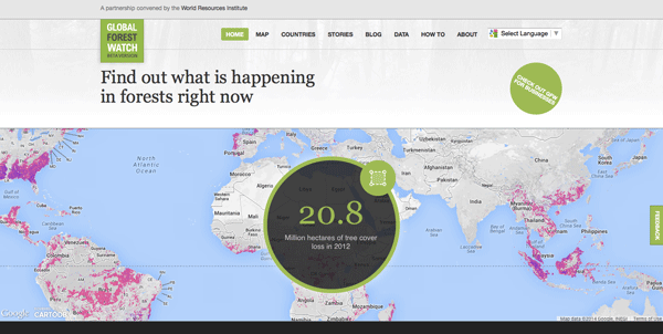
Global Forest Watch: A Real-Time Mapping Project
Data from Global Forest Watch, an online forest monitoring and alert system is now available via an online mapping platform. Users of this data portal can add maps, datasets, and applications to their forest projects and better analyze indicators of forest change.

Maps as People: Anthropomorphic Maps
Cartographers have been creatively crafting heads and bodies out of mountain ranges, coastlines, and other physical features. These anthropomorphic maps were intended mostly as propaganda pieces to show off the might of one country or stereotype foreign lands.

Underwater Global Warming
Scientists are using satellites and remote sensing to better understand changes in sea-surface temperatures.

Satellites Show the Thinning of Alaskan Ice
In general, climate change is a term that refers to the significant transformations in global weather patterns over an extended ...

Taking the Earth’s Temperatures by Satellite
Just like a physician measures a person’s temperature in order to check his or her health, a new project from ...

Saving Leatherback Turtles through Maps
Finding a balance between the needs of humans with those of the natural environment has always been a challenge. There ...

LiDAR and the Archaeology Revolution
Through the use of LiDAR, archaeologists are now able to uncover more of the ‘lost’ New England of subsistence farming from the 1700s.

Predicting Natural Disasters and Humanitarian Crises through GIS
The National Geospatial-Intelligence Agency (NGA) wants to create a data-rich map with its proposed Project GeoAnalytics that takes into account not only the physical characteristics of certain locations around the globe but also include supplementary information about its people and the political situation.

Mapping the Earth’s Polar Regions
In order to better understand the Earth’s Polar Regions, improved maps are continually being developed. The latest of these is a set of high-quality satellite images of Antarctica from the Polar Geospatial Center. The PGC has made them accessible through several web-based mapping applications.

Creating a Sustainable Space Environment Using Satellite Sails
European Space Agency scientists are pioneering sustainable space technology through satellite innovation.