

All of us in one degree or another rely on maps. Whether we use a road atlas on a family vacation, pull out our smartphones when lost in an unfamiliar neighborhood, or employ our mental maps of our homes to navigate in the dark, maps play a large role in our everyday existence.
But the nature of maps as portrayals of the world mean that they can both represent physical reality but also create it at the same time.
A map can be defined as a symbolic representation of a place that presents information about the world visually. According to this definition, the very nature of a map means that its purpose should be to depict, in the truest way possible, the physical reality of the Earth.
The problem is that no one map absolutely portrays reality as it exists in the truest sense. The character of maps distorts physical reality at the same time. Since the Earth is round and most maps are two-dimensional, commonly drawn on a flat surface, no one map can be completely accurate.
How Map Projections Affect Perceptions of Reality
There have been a number of attempts to solve this problem with the invention of different map projections. Yet, these map projections, in their efforts to be faithful to reality, end up misrepresenting the Earth simultaneously. (More: Cartographic Anomalies: How Map Projections Have Shaped Our Perceptions of the World)
For example, one of the most popular map projections is the Mercator, drawn by a Flemish geographer and cartographer in 1569. The Mercator projection is the most usual for navigation because it connects any two points on the map with a straight line in the same direction that a compass would. All of this projection’s longitude and latitude lines connect at right angles which correctly maintain direction.
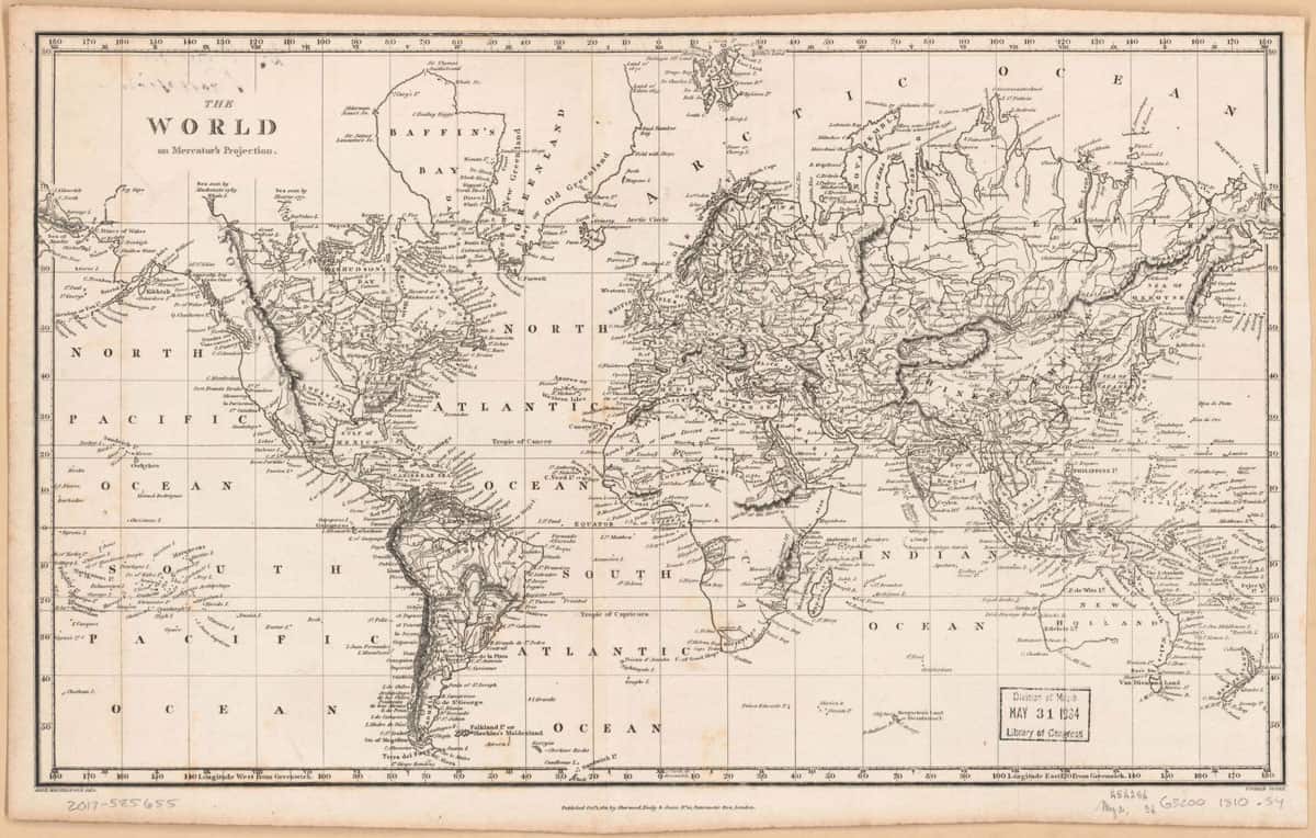
However, in its attempts to be true to direction, the Mercator project distorts distances, shapes, and area. There are large distortions to the perimeters of these maps, in the Arctic and Antarctic regions.
These distortions can give the wrong impressions about the correct shape of many of the continents. Any elementary school child seeing this particular projection for the first time might not comprehend that Antarctica is not as big as it appears on the map. He or she will get a distorted representation of the Earth.
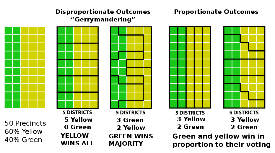
Gerrymandering and Maps
Other problems that evolve from the nature of maps include the way that mapmakers misrepresent reality in order to advance their own purposes. For instance, we get the word Gerrymander from the political tactic of drawing congressional districts on maps in order to favor one political party over another. Various political groups throughout history have attempted to modify maps in order to advance their causes.
At the same time, this is what maps are for. They are representations of reality according to the rules that the particular mapmaker follows and what he or she seems most important.
Most of us feel that the direction of up is north on a map, downwards is south, east is to the right, and west is of the left. A large city is represented by a dot while a road is a black line.

Still, these symbols are almost entirely arbitrary. Another mapmaker could change his or her map orientation so that north is to the left, south is to the right, and so on. A black line could represent a waterway while a blue line could represent a road. Is it possible that symbols and names on a map are there because we have agreed to use them for geographic features?
Mental Maps: How We Perceive Geography
Another factor to consider is that of mental maps. Mental maps are an individual’s internal map of their own known world and we tend to be more familiar with the area directly surrounding us than areas farther away.
Studies of college students demonstrated that they almost always viewed their own local area more positively and were more likely to stay in the area where they grew up. It is also interesting to note that the mental maps of those in lower socioeconomic groups usually cover a smaller geographic area than the mental maps of the more affluent.
Mental maps are our own imaginatively created representations of the physical world.

This is not to say that maps have no basis in reality but they will always have some degree of distortion because of their very nature. Maps are representations of the physical world but at the same time they also create reality for us. Maps have a strong influence on how we think about and interact with the material world around us.
References:
“Do Maps Create or Represent Reality?” http://citymovement.wordpress.com/2012/05/09/do-maps-create-or-represent-reality/
“Gerrymandering.” http://en.wikipedia.org/wiki/Gerrymandering
“What is a Map?” https://www.geographyrealm.com/map/
“Common Map Projections” https://www.geographyrealm.com/common-map-projections/
“Map Orientation.” https://www.geographyrealm.com/map-orientation/
“Why the Middle East’s borders will never be the same again.” http://www.cnn.com/2014/06/20/opinion/middle-east-borders-redrawn/
“What are Mental Maps?” https://www.geographyrealm.com/mental-maps/